Lee makes landfall in Nova Scotia with 70 mph winds. A tropical depression could develop
Former Hurricane Lee made landfall Saturday afternoon as a post-tropical cyclone in western Nova Scotia.
Lee's maximum sustained winds were 70 mph at the 4 p.m. special advisory from the National Hurricane Center.
Hurricane and tropical storm conditions were being felt across New England and Atlantic Canada on Saturday, and storm surges, downed trees and power outages were seen across the region.
Highlights from the 11 a.m. advisory:
Lee remains a powerful storm with near-hurricane strength as it nears landfall in Maine or Atlantic Canada on Saturday.
Hurricane conditions are possible across portions of southern New Brunswick and Nova Scotia.
Heavy rainfall from Lee may produce localized urban and small stream flooding. Strong winds are already downing trees and causing power outages.
Dangerous surf and life-threatening rip currents will continue to affect the U.S. East Coast, Atlantic Canada, Bermuda, the Bahamas, the Turks and Caicos Islands, Hispaniola, Puerto Rico, the Virgin Islands and the northern Leeward Islands through the weekend.
Lee was expected to impact the weather for the college football game between No. 3 Florida State and Boston College.
Elsewhere in the Atlantic, Tropical Storm Margot has weakened and is expected to continue to do so. Meanwhile, a tropical depression is expected to form into Tropical Storm Nigel this weekend.
And the NHC is monitoring another tropical wave off the coast of Africa.
Keep track of Lee and its impacts
Bookmark these links to keep track of Hurricane Lee and its effects across New England:
➤ Hurricane Lee spaghetti models
Here's the latest update from the NHC as of 5 p.m.:
Forecast path: Where is Lee going?
Lee made landfall on Long Island in Nova Scotia about 4 p.m. Saturday. Lee was expected to turn to the northeast and move across Atlantic Canada on Saturday night and Sunday.
Impact of Lee on Florida, US East Coast
Lee may be far away near New England, but its impacts are still being felt off the shore in Florida.
The National Hurricane Center warned swells from Lee are affecting the waters on the U.S. East Coast and islands in the Caribbean. Life-threatening surf conditions and rip current are possible.
Lee impacts: What to expect and when
Wind: Hurricane conditions are possible in the hurricane watch areas in Atlantic Canada later today. Tropical storm conditions are occurring along the coasts of Maine and Nova Scotia and will spread northward within the tropical storm warning area today and tonight.
The strong winds are leading to downed trees and power outages. Tropical storm-force gusts are likely to continue on Cape Cod for a couple more hours.
Storm surge: Water levels remain elevated along the New England coast and will begin to subside after the next high tide cycle. For information specific to your area, please see products issues by your local National Weather Service forecast office.
A dangerous storm surge will produce will produce coastal flooding within the wind warning areas in Atlantic Canada in areas of onshore winds. Near the coast, the surge will be accompanied by large and destructive waves.
Surf: Swells generated by Lee are affecting the U.S. Virgin Islands, Puerto Rico, Hispaniola, the Turks and Caicos Islands, the Bahamas, Bermuda, the east coast of the United States and Atlantic Canada. These swells are likely to cause life-threatening surf and rip current conditions. Please consult products from your local weather office.
Rainfall: Through tonight, Lee is expected to produce rainfall amount of 1 to 4 inches over far eastern Massachusetts, eastern Maine, western Nova Scotia and New Brunswick. This could produce localized urban and small stream flooding.
Lee: Forecast path and how strong is it?

Special note on the NHC cone: The forecast track shows the most likely path of the center of the storm. It does not illustrate the full width of the storm or its impacts, and the center of the storm is likely to travel outside the cone up to 33% of the time.
Location: 50 miles east-southeast of Eastport, Maine and 125 miles west of Halifax, Nova Scotia
Maximum wind speed: 70 mph
Direction: north at 16 mph
As of 5 p.m., Post-Tropical Cyclone Lee was located near latitude 44.5 North, longitude 66.1 West. The post-tropical cyclone is moving north near 16 mph. A faster northeast motion is expected during the next day or so, taking the system across the Canadian Maritimes.
The center of Lee made landfall off Long Island in Nova Scotia on Saturday afternoon.
Maximum sustained winds are near 70 mph with higher gusts. Steady weakening is forecast during the next couple of days.
Tropical storm-force winds extend outward up to 320 miles. An observation in Bangor, Maine, recently reported a wind gust of 52 mph. An observing site in Halifax, Canada, reported a sustained winds of 52 mph and a gust of 60 mph. An observation in Vinal Haven, Maine, reported a sustained wind of 44 mph.
The estimated minimum central pressure is 970 mb.
Watches and warnings in effect in anticipation of Lee's arrival
A tropical storm warning is in effect for:
Cape Elizabeth north to the U.S./Canada border
New Brunswick from the U.S./Canada border to Belledune, including Grand Manan Island
All of Nova Scotia
Prince Edward Island
Magdalen Islands
Lee maximum sustained winds forecast
Prediction and timing of winds:
12 hours: 60 mph (post-tropical)
24 hours: 45 mph (post-tropical)
36 hours: 40 mph (post-tropical)
48 hours: 40 mph (post-tropical)
60 hours: dissipated
Spaghetti models for Lee
Special note about spaghetti models: Illustrations include an array of forecast tools and models, and not all are created equal. The hurricane center uses only the top four or five highest performing models to help make its forecasts.
Tropical Storm Margot

Location: 745 miles west-southwest of the Azores
Maximum sustained winds: 50 mph
Movement: west at 8 mph
As of 5 p.m., the center of Tropical Storm Margot is located at latitude 34.3 North, longitude 39.6 West. Margot is moving west at 8 mph, and it is expected to continue making a slow clockwise loop during the next day or two. A faster northeastward to eastward motion is forecast by early next week.
Maximum sustained winds have decreased to 50 mph with higher gusts. Gradual weakening is forecast during the next couple of days, though slight fluctuations in intensity are possible.
Tropical storm-force winds extend outward from the center up to 255 miles from the center. The estimated minimum central pressure is 996 mb.
Spaghetti models for Tropical Storm Margot
Tropical Depression 15: When will it become a hurricane?

Location: 1,005 miles east-northeast of the Lesser Antilles
Maximum sustained winds: 35 mph
Movement: north-northwest at 16 mph
At 5 p.m., the center of Tropical Depression 15 was located near latitude 20.8 North, longitude 47.1 West. The depression is moving north-northwest near 16 mph, and this motion is expected to continue over the next few days.
Maximum sustained winds are near 35 mph with higher gusts. Some strengthening is forecast during the next 48 hours, and the system could become a hurricane by early next week.
The estimated minimum central pressure is 1,006 mb.
What else is out there and how likely are they to strengthen?

Tropical wave: A tropical wave is forecast to move off the west coast of Africa by midweek. Environmental conditions are forecast to be conducive for gradual development as the system moves west across the eastern tropical Atlantic.
Formation chance through 48 hours: low, near 0 percent.
Formation chance through 7 days: low, 30 percent.
Who is likely to be impacted?
Tropical Storm Margot poses no threat to land.
It's too early at this time to determine if there will be any impact to the U.S. from Tropical Depression 15 or the tropical wave moving off Africa.
Forecasters urge all residents to continue monitoring the tropics and to always be prepared.
Weather watches and warnings
When is the Atlantic hurricane season?
The Atlantic hurricane season runs from June 1 through Nov. 30.
When is the peak of hurricane season?
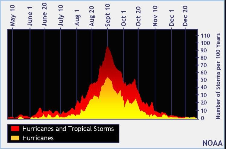
The peak of the season is Sept. 10, with the most activity happening between mid-August and mid-October, according to the Hurricane Center.
Tropical forecast over the next seven days
Excessive rainfall forecast
What's out there?
Systems currently being monitored by the National Hurricane Center.

Noaa
Embedded content: https://www.nhc.noaa.gov/xgtwo/two_atl_0d0.png?052051
What's next?
We will continue to update our tropical weather coverage daily. Download your local site's app to ensure you're always connected to the news. And look at our special subscription offers here.
This article originally appeared on Treasure Coast Newspapers: National Hurricane Center tracking Lee, Tropical Depression 15, Margot

