Lee turns deadly as powerful storm bombards Maine, Nova Scotia
The ferocity of Lee was unleashed on New England and the Canadian Maritimes over the weekend, ending the nearly two-week journey of the most powerful storm of the 2023 Atlantic hurricane season.
The monstrous storm cut power to more than 280,000 electric customers across Maine, Nova Scotia and New Brunswick as it roared ashore on Saturday afternoon. In doing so, Lee became the third named storm to make landfall in North America this hurricane season, following Tropical Storm Harold, which made landfall in southern Texas in mid-August, and Hurricane Idalia, which slammed into western Florida at the end of August.
One fatality has been confirmed in connection with the storm after a large tree limb fell on a motorist amid high winds in Searsport, Maine, according to The Associated Press. Elsewhere, a large tree fell on a police vehicle in Cohasset, Massachusetts, but the officer was able to run to safety and was not injured.
Another tree fell through a vehicle's windshield on Route 11 in Moro Plantation, Maine, according to Maine State Police. John Yoder, 23, of Apple Creek, Ohio attempted to stop but couldn't avoid the tree. Yoder suffered minor cuts, but the other five passengers in the van were not injured, according to the Associated Press.
Storm chaser Aaron Rigsby reported that a large tree toppled down on top of a residence in Rockland, Maine, while the owner was taking refuge in the basement.
CNN also attributed the drowning death of a 15-year-old in Fernandina Beach, Florida, to Lee's rough surf, which the storm stirred up along the East Coast for days in advance of landfall.
 |
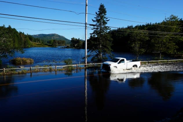
A motorist travels through flood waters on a road that remains closed a day after storm Lee passed through the region, Sunday, Sept. 17, 2023, near Northeast Harbor, Maine. (AP Photo/Robert F. Bukaty) |
Preparations for Lee's foreseen impacts began late last week from the coast of New England into Nova Scotia and New Brunswick, Canada.
Lobstermen voyaged out to the turbulent sea ahead of the storm to pull in their traps, and amid the frenzy, one boat capsized and sank, according to The AP. One of two people onboard was Bill Bob Faulkingham, who serves as the House Republican leader of Maine's Legislature. Fortunately, emergency crews were able to rescue the two people before the boat sank.
"They're very lucky to be alive," Winter Harbor Police Chief Danny Mitchell said.
Many popular tourist destinations in Maine closed ahead of Lee's arrival, including Acadia National Park and businesses in Bar Harbor, located just outside the boundary of the park along the coast.
Airports across the region also temporarily shuttered ahead of Lee's arrival, including Halifax Stanfield International Airport in Nova Scotia, where all flights scheduled for Saturday were canceled.
Although the worst of the storm stayed north and east of Boston, more than 220 flights at Boston Logan International Airport were canceled, according to FlightAware. Winds at the airport frequently gusted over 40 mph on Saturday afternoon as the storm brushed the region's coast.
In Nova Scotia, Lee was just the latest chapter in a year filled with weather disasters.
Around the end of May, wildfires flared across the Canadian province that burned more than 66 square miles and sent massive plumes of smoke into the atmosphere that drifted over the northeastern United States.
Nearly two months later, severe thunderstorms unloaded around 10 inches of rain in part of the region that triggered deadly flooding and caused infrastructure to crumble.
"People are exhausted. ... It's so much in such a small time period," Pam Lovelace said, according to The AP. Lovelace serves as a councilor in Halifax, the most populated city in Nova Scotia. "From a mental health perspective, we're asking people to check in on their neighbors."
The effects of Hurricane Lee began to be felt across coastal New England and Nova Scotia on Friday, Sept. 15, as the center of the storm tracked toward the tip of southern Nova Scotia.
Conditions deteriorated Friday night and throughout the day on Saturday leading up to landfall, which took place around 4 p.m. EDT at Long Island, located on the southwestern extent of Nova Scotia.
On its final approach to landfall, Lee lost some of its tropical characteristics, which caused its fury to grow. Tropical storm-force winds extended roughly 400 miles from the center of the storm, while hurricane-force wind gusts spanned around 150 miles from its eye.
 |
A satellite image of Lee around the time that it made landfall in Nova Scotia on Saturday. (NOAA/GOES-EAST) |
Lee's rage continued after landfall, with heavy rain and strong winds spreading northward into New Brunswick, eastern Quebec, and Newfoundland and Labrador.
Lee's journey to landfall started more than 11 days prior in the form of a tropical depression in the central Atlantic Ocean on Tuesday, Sept. 5. Six hours after being declared a depression, it was upgraded to be the twelfth tropical storm of the season. And Lee was showing no signs of slowing down.
In just 18 hours on Sept. 7, Lee rapidly intensified from a Category 1 hurricane with maximum winds of 80 mph to a powerhouse Category 5 hurricane with winds of 160 mph -- the first Category 5 storm of the 2023 Atlantic hurricane season. At peak strength, Lee packed winds of 165 mph, making it the strongest hurricane in the Atlantic basin since Dorian in 2019, which had catastrophic winds of 185 mph.
Previously, Franklin held the title of the Atlantic's strongest hurricane this year, which peaked at Category 4 strength with winds of 150 mph. To be considered a Category 5, sustained winds must be at least 157 mph.
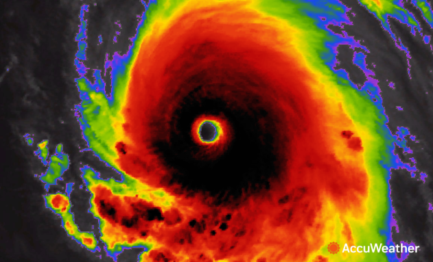
 |
Category 5 Hurricane Lee late on Sept. 7, 2023. |
The strength and longevity of Lee have also helped boost the 2023 Atlantic hurricane season in a statistic known as accumulated cyclone energy (ACE). Intense, long-lived systems like Lee generate a high amount of ACE, while weak, short-lived systems only amount to a small ACE.
"Tropical meteorologists use the value to compare storms and seasons in order to help understand what has happened," AccuWeather Hurricane Expert Dan Kottlowski said. Kottlowski added that the 30-year historical average for ACE in the Atlantic hurricane basin is 123.
As of Friday, Sept. 15, the ACE for the current hurricane season was 104.8, higher than the 2022 season, which only had an ACE of 95.1, according to Colorado State University.
Lee has generated an ACE of 36.8, more than one-third of the ACE for the entire season thus far.
Idalia had a more significant impact on lives and property across the Southeast compared to Lee's impact on New England and the Canadian Maritimes, but since Idalia was only a named form for four days and a hurricane for less than half that time, it had an ACE of 7.4
As Lee tracks northeastward over Canada and loses wind intensity, a new tropical threat is brewing in the Atlantic.
Hurricane Nigel, named late Saturday evening, is currently swirling over the central Atlantic and is forecast to strengthen into a major hurricane in the coming days.
Earlier last week, AccuWeather meteorologists explained that Nigel could follow in the footsteps of Lee, tracking close to the U.S. coast and potentially swiping Bermuda and Atlantic Canada. However, the storm is now forecast to take a northward turn earlier than previously predicted, which should steer it away from North America.
"Should the storm track farther to the west, rain and gusty winds may also impact Bermuda," AccuWeather Senior Meteorologist Adam Douty said. "Aside from these potential impacts to Bermuda, no additional impacts to land are expected."
Want next-level safety, ad-free? Unlock advanced, hyperlocal severe weather alerts when you subscribe to Premium+ on the AccuWeather app. AccuWeather Alerts™ are prompted by our expert meteorologists who monitor and analyze dangerous weather risks 24/7 to keep you and your family safer.


