Let it snow? Winter predictions start as El Niño strengthens. Here's what forecasters say.
For those already pulling out sweaters and boots and hoping for a cold, snowy winter, the coming months could be disappointing, thanks to the influence of a strengthening El Niño.
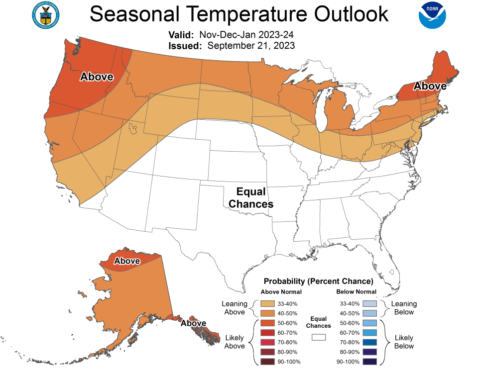
Much of the northern half of the country is forecast to see greater chances for warmer than normal temperatures, thanks to a combination of El Niño and ongoing patterns of above-average heat in general, according to the latest predictions from the National Oceanic and Atmospheric Administration. That's especially the case for Maine and parts of western Washington and Oregon.
Across the South and much of the Atlantic coast into southern New England, the forecast calls for greater chances of a wetter than normal winter, said NOAA's Climate Prediction Center. Parts of the Northwest, Mountain West and Great Lakes could see greater chances of below-normal precipitation.
“El Niño is here and still growing stronger,” said Robert Rohde, lead scientist for Berkeley Earth, an independent nonprofit focused on climate analysis. The naturally occurring climate pattern occurs when trade winds weaken over the tropical Pacific Ocean and push warmer water east toward South America.
The combination of El Niño and the ongoing abnormally warm temperatures in the oceans and atmosphere make it harder to accurately predict what may happen in the months ahead, meteorologists and climate scientists said this week.
How does El Niño typically impact winter in the US?
◾ The southern third of the U.S. typically experiences wetter-than-average conditions, while the northern third sees higher chances for below-normal precipitation.
◾ Conditions can be much wetter on the Gulf Coast and in Florida.
◾ Wetter than normal in parts of California.
◾ Drier than normal in Ohio Valley and the Northwest.
◾ Increased chances for tornadoes in Central and South Florida.

Warm temperatures may interfere with El Niño pattern
Lingering warm ocean temperatures make the forecast for the coming months particularly challenging this year, meteorologist Scott Handel, the climate center’s head of forecast operations, wrote in a Monday forecast.
El Niño and La Niña are two phases of a multiyear cycle that takes place near and along the equator in the Pacific Ocean. Both can have widespread influence over weather in the U.S. and around the globe. Temperature differences influence the positioning of the jet stream that controls much of the nation's weather, with drier air to the north and wetter weather across the South during El Niño winters. But that influence isn't always the same.
Discerning how conditions might respond to El Niño and the record warmth in many locations is one of the “major forecast challenges,” Rohde said. “El Niño effects will play a large role on weather patterns in coming months, but the unusual conditions in other ocean basins may make weather patterns this year harder to predict than in other El Niño years."
Combined, they're also contributing to a rise in global temperatures that is even faster than we would expect from an El Niño transition alone, Rohde said Tuesday.
Earlier this year, seasonal hurricane forecasters expected El Niño to increase wind shear over the Atlantic Ocean and break apart tropical storms and hurricanes. But evidenced by the fact that the season could see its 17th named storm later this week, scientists say record warm ocean temperatures outweighed much of the typical El Niño influence on tropical cyclones. The official season total of 18 includes an unnamed system in January.
A similar phenomenon may occur this winter, with lingering warm temperatures having an outsized influence, forecasters said.
There's a lot going on in the global atmosphere and ocean sphere, Daniel Swain, a climatologist at the University of California, Los Angeles, wrote in his Weather West, a California weather and climate perspectives blog last week. "With record-breaking ocean warmth and a strong or very strong El Niño in place through the winter, it raises the risk of worsening drought in the Pacific Northwest and Hawaii. But it increases the odds of a wetter than usual winter in California."
The latest forecast shows the South with equal chances of above or below-normal temperatures this winter.
El Niño strengthening
Here's the latest from seasonal forecasts:
◾ There's a 95% chance El Niño will linger through March.
◾ Chances for a strong El Niño by late fall and into January have climbed to 70%.
◾ Chances for a "very strong" El Niño have climbed to 30%.
What does El Niño and other warmth mean for global average temperatures in 2023?
With the boost from El Niño, it is likely that 2023 will have the warmest global annual average since instrumental measurements began in 1850, Rohde told USA TODAY.
“The Earth right now is far warmer than the previously measured record for this time of year,” he posted on X, formerly Twitter. “Even with a growing El Niño, the pace and size of the uptick that we've seen this year is pretty shocking.”
This article originally appeared on USA TODAY: El Niño winter outlook from NOAA notes snow, temperature forecast

