Flood watch in effect all day as ‘significant rainfall’ continues to soak South Florida
And rain fell on Florida for three days and three nights ...
Perhaps not the biblical 40 — yet, it seems — but another full day of soaking rains and thunderstorms is in store for South Florida Wednesday, prompting the National Weather Service in Miami to issue another flood watch.
The flood watch runs 10 a.m. through 8 p.m. Wednesday, June 16, for much of South Florida, including coastal Miami-Dade, Broward, Monroe and Collier counties. Also far south and inland Miami-Dade, Broward and Collier, mainland Florida Keys and metro areas of Miami-Dade and Broward.
According to the weather service, “significant rainfall may aggravate already saturated grounds. Slow-moving showers and thunderstorms could result in wide spread flooding.”
Meteorologist’s message: “Turn around, don’t drown when encountering flooded roads.”
Jun 16: Another round of showers and storms across the region today. Heavy rainfall, leading to flooding, gusty winds and lightning strikes will be possible. A Flood Watch is in effect for portions of South Florida. #flood #flwx pic.twitter.com/RvgVCxNros
— NWS Miami (@NWSMiami) June 16, 2021
Brian McNoldy, senior researcher for the University of Miami’s Rosenstiel School of Marine and Atmospheric Science said that 3.74 inches of rain fell Tuesday — the 15th rainiest day he’s observed in his over nine years of recording observations.
“A daily total like that has an average return period of about seven months,” he said on Twitter Wednesday morning.
I ended up with 3.74" of rain for the daily total (the 15th rainiest day in my 9+ years of observations). In fact, today is my 3300th daily measurement, so that's in the top 0.5%! Also based on my history, a daily total like that has an average return period of about 7 months. pic.twitter.com/K22zyJCWKm
— Brian McNoldy (@BMcNoldy) June 16, 2021
Rain chances are up to 70% into Wednesday evening, according to the weather service and local meteorologists.
WATER VAPOR IMAGERY clearly shows deep tropical moisture streaming into South Florida from the Caribbean due to winds out of the SW. Because of this, expect another round of heavy rain and storms today, leading to a flood risk this afternoon. #7weather pic.twitter.com/TiBqiQK7JE
— Vivian Gonzalez (@VivianGonzalez7) June 16, 2021
Heading to Orlando?
Much of the state is dealing with unsettled weather.
Orlando, for instance, could see another round of storms Wednesday, mostly southeast of Orlando, according to the weather service’s hazardous weather outlook for the region. Flooding is possible, as are wind gusts up to 60 mph. Small hail and brief tornadoes, mainly along and south of Cape Canaveral, can’t be ruled out, according to the service.
These rains could drop 1 to 3 inches in a 60 to 90 minute period. “This may cause travel delays as driving becomes more challenging,” meteorologists said.
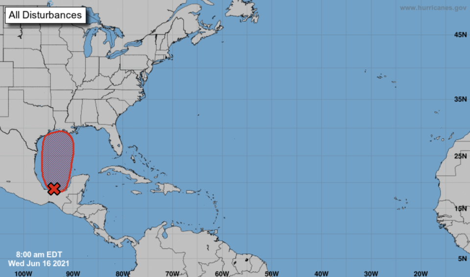
Tracking a disturbance
Need more proof the rainy season’s upon us? The National Hurricane Center is tracking a disturbance near the Bay of Campeche off the coast of Mexico that could steer toward Northwest Florida later this week — possibly as a tropical depression. The system could drop up to 7 inches of rain wherever it lands.
A soggy start to the week
The work week started soggy in South Florida, with strong wind gusts approaching 75 mph in Broward and, on Monday, the driver of a rented Nissan Rogue had a shocking moment on Interstate 75 around mile marker 30.5 when a rogue lightning bolt zapped the car’s antenna and also gouged a seven-foot-long, four-inch-wide stripe in the pavement, the Florida Highway Patrol said.
It continued Tuesday with vicious early-afternoon downpours across much of Miami-Dade bringing flood warnings.
Wicked.
National Weather Service in Miami meteorologist Robert Garcia told the Miami Herald more severe weather could be on tap into the week as the “unsettled pattern is going to continue.”
On Tuesday, that prediction hadn’t changed.
Flood advisory issued
Sure enough, a flood advisory was issued around 1:30 p.m. Tuesday by the National Weather Service, running through 4:45 p.m.
The alert came as up to two inches fell on areas including Miami, Miami Beach, Hialeah, Miami Lakes, Coral Gables, South Miami, Miami Gardens, Kendall, Virginia Key, North Miami and North Miami Beach, Aventura, Sunny Isles Beach, Doral, Sweetwater, Surfside, Opa-locka, Miami Springs, Miami Shores and Miramar.
STREET FLOOD ADVISORY in effect for a portion of Miami-Dade county. Heavy rainfall is creating areas of street flooding. Avoid roads covered by water of unknown depth. pic.twitter.com/jsmBi949y5
— CBS4 Miami (@CBSMiami) June 15, 2021
A flash flood warning was also issued until 5:15 p.m. for a smaller area, which includes Aventura, Miami Gardens Miami Lakes, Doral, Miami Springs, Hialeah and Miami Shores.
For flash floods, authorities say to move immediately to higher ground and avoid walking or driving through flood waters.
Flash Flood Warning including Hialeah FL, Miami Gardens FL, North Miami FL until 5:15 PM EDT pic.twitter.com/mP50fnfXmU
— NWS Miami (@NWSMiami) June 15, 2021
Scattered to numerous showers and thunderstorms — a 70% afternoon chance after the morning’s respite — fell by mid-day and the warnings suggested some of these storms could contain strong winds topping 45 mph, along with the heavy downpours and small hail. Waterspouts, too.
One such deluge, with wind gusts around 45 mph, moved through Hialeah Tuesday afternoon, with a severe weather alert issued for the area through 2:30 p.m., reported WSVN meteorologist Vivian Gonzalez.
Tracking a STRONG STORM near Hialeah moving NE at 10 mph. It could produce winds in excess of 45 mph in the shaded area in yellow through 2:30 pm. @wsvn @7weather #flwx pic.twitter.com/P9SfCcJRjR
— Vivian Gonzalez (@VivianGonzalez7) June 15, 2021
That wet forecast with an improved weekend applies to most of Florida’s east coast, as well as Bradenton, according to NWS meteorologists. The Keys also will share the weather pattern, with isolated thunderstorms possible through Monday.
Bradenton adds a dangerous rip current alert for Pinellas and coastal Hillsborough, Manatee, Sarasota, Charlotte and Lee counties through 11 p.m. Tuesday.
545 AM | Higher coverage of showers and lightning storms continues across east central Florida today with another early initiation and potential multiple rounds as well as localized flooding. Some storms strong to severe later today. Hot & Humid - stay hydrated! pic.twitter.com/AbmmCQKM16
— NWS Melbourne (@NWSMelbourne) June 15, 2021
Jun 15: A wet & windy day yesterday, with reports of lightning damage, wind damage, & flooding. Another soggy day is expected today so please keep weather aware. With plenty of rain across the east coast areas yesterday, it won't take too much to get localized flooding today. pic.twitter.com/zK3ewiArXD
— NWS Miami (@NWSMiami) June 15, 2021
When is it going to dry out?
Can you wait to Friday?
By Thursday night’s slight chance of showers, Friday eyes a mostly dry 20% storm chance. Saturday and Sunday will remain cloudy, but rain chances are 20%-30% and storms shouldn’t be as popping as on Monday, Tuesday and Wednesday, according to the weather service.
NBC6 meteorologist Adam Berg goes along with that forecast, adding that temperatures will heat up again once the rain tapers, hitting the low 90s Saturday through Monday.
“But we will have a subtle beach breeze to take the edge off ... a little,” Berg tweeted ... enticingly.
Afternoon storms will be with us for the next few days then we get a break. Temperatures will warm back to the 90s but we will have a subtle beach breeze to take the ede off...a little. @nbc6https://t.co/PKdbgxwLAa pic.twitter.com/RslRDUtiKv
— Adam Berg (@AdamBergNBC6) June 15, 2021
Miami Herald Reporter Devoun Cetoute contributed to this report.

