Idalia Big Bend updates: Leon County on hurricane watch; storm surge threat increases
We’re tracking Hurricane Idalia… Join us for an update from local leaders on the timing and impact to Leon County. Please make sure all of your emergency plans are in place. Stay connected by visiting LeonReady.com.
Posted by Leon County Sheriff's Office on Monday, August 28, 2023
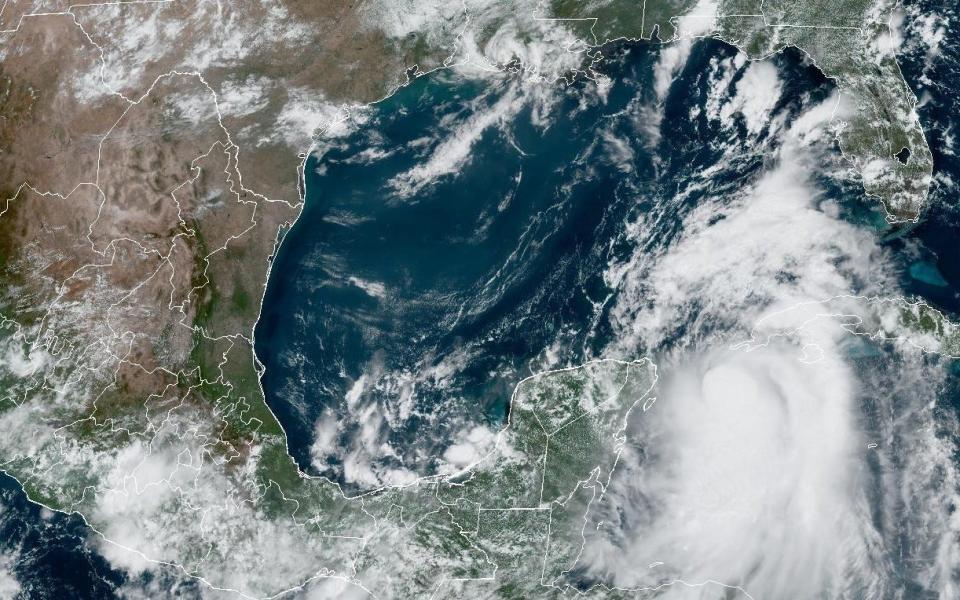
Tallahassee and surrounding Big Bend communities are bracing for the arrival of Idalia, which is forecast to become a major hurricane before making an anticipated landfall on Wednesday.
Though the storm track continues to shift and uncertainty remains, forecasters said Idalia could come ashore somewhere along the coast of Taylor of Dixie counties. The National Hurricane Center nudged the track further west late Monday, raising the worry level in the capital city.
Beyond delivering devastating Category 3 strength or higher winds at the coast, Idalia could bring "life-threatening" storm surge between 7 and 11 feet near and to the east of where the center makes landfall, according to the National Weather Service in Tallahassee.
Wakulla County issues voluntary evacuation orders, says shelters not strong enough to open
Wakulla County issued a voluntary evacuation order for coastal and low-lying areas as well as for residents living in mobile homes.
"Just because our area is on the edge of the current cone doesn't mean we are not likely to be impacted by this storm or even take a direct hit," the Sheriff's Office said in a Facebook post. "This is a rapidly evolving situation, please remember the time to prepare and plan is now."
Wakulla County Emergency Management said its shelters were not rated to withstand a Category 3 hurricane and will not open for Idalia. The county directed evacuees to shelters in Tallahassee.
The school district will open emergency shelters Tuesday evening at Chiles High School, Lincoln High School, Rickards High School and Fort Braden K-8 School.
Leon County under hurricane watch, tropical storm warning; hurricane warning issued for Franklin County
Leon County is under a hurricane watch, meaning hurricane-force winds are possible within the next 48 hours. However, the National Weather Service still says peak winds are forecast between 15-25 mph, with gusts to 40 mph.
Hurricane and storm surge warnings have also been issued for St. Marks and Panacea in coastal Wakulla County and Apalachicola, Eastpoint, Carrabelle and Alligator point in coastal Franklin County. Inland Jefferson County, including Monticello and Wacissa.
Meanwhile, storm surge predictions for Florida's Gulf Coast have become more dire with the 5 p.m. forecast from the National Hurricane Center in Miami.
Storm surge could range from 8 to 12 feet from the Aucilla River, which divides Jefferson and Taylor counties, southeast to the Chassahowitzka River in Citrus County; 5-8 feet from the Aucilla River to the Ochlockonee River; 3-5 feet from the Ochlockonee River to Indian Pass; and 1-3 feet from Indian Pass to Mexico Beach.
FAMU, TCC to close because of Idalia
Florida A&M University's main campus on Tallahassee and its Center for Viticulture and Small Fruit Research and Gadsden County facilities will close on Wednesday.
FAMU's dining facilities plan provide food and water for students, who are urged to shelter in place.
Tallahassee Community College announced that its main campus, the Center for Innovation, the Gadsden Center and the Ghazvini Center for Healthcare Education will close beginning at 5 p.m. Tuesday and continuing through Wednesday. TCC's Wakulla Center and Wakulla Environmental Institute will close starting Tuesday. Normal operations are expected to resume Thursday, TCC said.
City enlists outside electric utility workers to help with line repairs
Tallahassee Mayor John Dailey said during an afternoon news conference that the city has enlisted mutual-aid from utilities from Louisiana, Ohio, Kentucky and Oklahoma with "contract crews" ready to assist if with power restoration if needed.
"They will all be arriving on Tuesday evening into our community," Dailey said. "Additional contract crews stand ready to assist all over the region."
Dailey's comments came during a news conference at the Leon County Emergency Operations Center, where he was joined by other local officials.
Leon County under local state of emergency as Idalia forecast to intensify
Leon County Commission Chairman Nick Maddox declared a state of emergency Sunday night, he announced during a Monday afternoon news conference. The county also activated its Emergency Operations Center to coordinate storm response.
"As we have seen over the past seven years with Hurricanes Hermine, Irma, Michael and Ian, Idalia will strengthen into a major hurricane before making landfall," Maddox said. "Leon County is bracing for strong winds and driving rain."
Idalia prompts Florida State University to cancel classes on Wednesday
FSU announced this afternoon that its Tallahassee campuses will close and classes will be canceled on Wednesday because of Idalia.
The university said main campus housing and dining operations will continue throughout the closure. Essential business operations also will continue.
"Deans and vice presidents will provide guidance for their respective colleges and divisions," the university said. "Employees designated by their department as essential personnel should consult with their supervisors."
Florida State University Schools (FSUS) also will be closed Wednesday.
Franklin County issues voluntary evacuation orders for barrier islands
Franklin County Emergency Management issued a voluntary evacuation order for people located on barrier islands and low-lying areas as well as those living in mobile homes and RV parks.
The county also opened sandbag sites in Carrabelle, Apalachicola and Eastpoint for the public. The sites are open until 5 p.m. Monday. Franklin County government offices will be closed Wednesday. Franklin County Schools are closed on Tuesday and Wednesday.
Jennifer Daniels, director of Franklin County Emergency Management, said storm surge of up to 6 feet was possible, though she called that a worst-case scenario.
To sign up for alerts, visit https://www.franklinemergencymanagement.com/alert-franklin/.
― Ana Goni-Lessan
Leon County Schools will be closed Wednesday in anticipation of Idalia
Leon County Schools will be closed Wednesday, Superintendent Rocky Hanna announced this afternoon. All after-school programs will be canceled after 6 p.m. Tuesday.
Leon County Schools will be open on Tuesday, August 29 and closed on Wednesday, August 30. Four of our schools will operate as shelters starting tomorrow at 5:00 pm.Tropical Storm Idalia could have significant impact to our local region. Please plan now for the arrival of the storm overnight Tuesday. We anticipate school being open on Thursday. If there are any changes, we will inform our community on Wednesday. After-school activities will be open until 6pm.
Posted by Leon County Schools on Monday, August 28, 2023
"This is a very serious storm, please do not be caught off guard," Hanna said in a video released on social media.
Forecasters say storm surge is biggest concern as Idalia makes Big Bend approach
Forcasters warned Monday that life-threatening storm surge remained the biggest threat to the Big Bend from Idalia.
Idalia, which is feeding off abnormally warm waters, is expected to strengthen into a major hurricane, with sustained winds of 111 mph or higher, by the time it makes landfall on Wednesday.
Peak storm surge could hit 7 to 11 feet from the mouth of the Aucilla River, which separates Jefferson and Taylor counties, southeast to the Chassahowitzka River. Points west are expected to see values between 2 to 7 feet. But Wright Dobbs, meteorologist with the National Weather Service, said that could quickly change if Idalia’s path fluctuates.
“We want to make sure that even if you’re on the west side of where it’s currently forecast to make landfall, you shouldn’t let your guard down,” Dobbs said. “Because it won’t take much of a westward shift to all of a sudden bring a lot higher surge potential.”
Forecasters said tropical-storm-force winds of 39 mph or higher could arrive as early as Tuesday night but are more likely to come on Wednesday. The Weather Service in Tallahassee said points in the eastern Big Bend how have between a 7 and 9 chance in 10 of seeing tropical-storm-force winds.
“If it shifts only a little bit, there's all of a sudden the possibility that we could see higher winds,” Dobbs said. “Additionally, if the storm strength is more than forecast, we could see a lot stronger winds.”
Contact Jeff Burlew at jburlew@tallahassee.com or 850-599-2180.
This article originally appeared on Tallahassee Democrat: Idalia Big Bend updates: Leon on hurricane watch, coast under warning

