Live Coverage: Hurricane Lee's predicted path, impact and expected damage in RI
Find the latest coverage on Lee's impact in Rhode Island on Saturday, Sept. 16 here: https://www.providencejournal.com/story/news/local/2023/09/16/tracking-hurricane-lee-tropical-storm-warning-coastal-flooding-power-outages-forecast/70864086007/
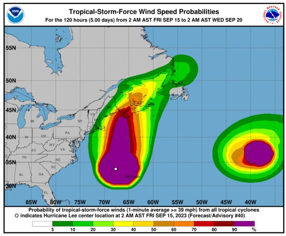
Blowing at 85 mph, Hurricane Lee was about 490 miles south-southeast of Nantucket and moving north at 16 mph early Friday morning, but the National Weather Service has lifted tropical storm watches for coastal Rhode Island.
For Rhode Island, the storm's greatest impact will likely be felt along the shore with dangerous waves, rip currents and potential erosion. A high surf advisory remains in place along the Ocean State's coast. At 3 a.m., waves in outer waters were already at 8 feet and expected to climb to 12 to 15 feet, according to the weather service.
At the shore, waves up to 14 feet are possible, and the Rhode Island Department of Environmental Management has advised residents that even watching from shore can be dangerous.
How big is Hurricane Lee
Lee had a diameter of tropical storm force winds or higher across 564 miles early this morning, with winds of hurricane force spanning 184 miles. The tropical wind field is larger than the equivalent of 15 Rhode Islands if you measure from the state from east to west, and larger than 3 Massachusetts – again measuring east to west.
How is the size of a hurricane measured?
It's easy to roughly guesstimate the size of a hurricane using forecasts and satellites, but experts use a more exact method to calculate the size of the wind fields within the storm.
The size of the wind field in each quadrant of the storm is spelled out in each of the hurricane center's forecast advisories.
Wind fields are fluid and can shift and move depending on what's happening within the storm and how close it is to land, where there's greater friction than over the water.
"It's complicated," said Daniel Chavas, an associate professor of atmospheric science at Purdue University who has spent much of his career so far working on wind size. "It's so complicated, that there's no defined list" of hurricanes by size, Chavas said.
The National Oceanic and Atmospheric Administration has easily accessible lists that compare hurricanes by wind speeds and barometric pressure, but not size.
~ Dinah Voyles Pulver, USA Today
Flight delays at Logan Airport in Boston and T.F. Green in Providence
Both major airports are showing limited delays and cancelations for Friday night and Saturday morning flights. Cape Air has canceled its 4:50 p.m. Friday and 6 p.m. Friday flights from Logan to Bar Harbor, Maine.
The message on Logan’s website says “Due to expected weather conditions, passengers are advised to check with their airline on the status of their flight before coming to the airport: https://loom.ly/OZ0LePU”
Red Cross offers power outage safety tips
In a news release Friday afternoon, the Red Cross noted that coastal flooding and tropical storm conditions are likely to cause downed trees and power outages in affected areas.
It offered the following tips to prepare for outages:
Use flashlights in the dark, not candles.
If you are using a generator, be sure you understand the risks of carbon monoxide poisoning and how to use generators safely. Never operate a generator inside homes, garages, basements, crawl spaces, sheds or other partially enclosed spaces, even if using a fan or opening doors and windows. Carbon Monoxide (CO) can quickly build up in these spaces and linger for hours after a generator is shut down. Place your generator outside, well away from the home.
Keep refrigerator and freezer doors closed as much as possible. An unopened refrigerator will keep foods cold for about 4 hours. A full freezer will keep the temperature for about 48 hours (24 hours if it is half full) if the door remains closed.
If it looks like the power outage will continue beyond a day, prepare a cooler with ice for your freezer items.
Turn off and unplug all unnecessary electrical equipment, including sensitive electronics.
Download the free Emergency app for instant access to full weather alerts, help preparing for emergency situations and open Red Cross shelter locations; visit redcross.org/apps.
Rhode Island power outage map: See where the power is out as Hurricane Lee nears
State of Emergency declared ahead in Massachusetts of Hurricane Lee to help with response
Gov. Maura Healey declared a State of Emergency in Massachusetts on Friday and is requesting that FEMA issue a pre-disaster emergency declaration, she made the announcement during a noon press conference. A state of emergency and an emergency declaration makes Massachusetts eligible for direct federal assistance for response costs, personnel, equipment, supplies and evacuation assistance.
Healey activated 50 National Guard troops for storm preparation and to be prepared to respond with high-water vehicles if needed.
Cancellations and postponements in RI
Hurricane Lee is already taking a toll on events that were scheduled for this weekend. A number of high-profile festivals and other events have announced cancellations or postponements, while others say they are sticking it out in hopes of an improvement in weather conditions by late Saturday into Sunday.
Here's a list of events that have been canceled or postponed. It will be updated throughout the day.
Hurricane Lee: Check here for cancellations and postponements in RI
McKee says RI is prepared for the storm
Gov. Dan McKee, speaking from the Rhode Island Emergency Management Agency on Friday morning, urged Rhode Islanders to remain guarded and ready for treacherous coastal conditions while expressing a sense of relief about the expected path of Hurricane Lee.
"For us not to be in a situation where we're not going to get a direct hit or some sort of a strong hit in a hurricane, this is good news for the people of the state of Rhode Island," McKee said, speaking at a news conference at the state's emergency operations center in Cranston.
McKee identified preparedness as the main gist of his messaging in advance of the expected storm.
"Let's keep our guards up over the next couple of days just in case and please stay tuned for updated information," McKee said.
Lt. Governor Sabina Matos said, "Getting through these events, like a hurricane requires that all of us are working together." She continued, "be a good neighbor" encouraging Rhode Islanders to check on their neighbors, especially those with disabilities and the elderly.
Newport sailors begin preparing for Hurricane Lee
Sail Newport posted this video saying, "It's already sporty here in Brenton Cove as Sail Newport staff and volunteers are busy making preparations for tonight's severe weather."
It's already sporty here in Brenton Cove as Sail Newport staff and volunteers are busy making preparations for tonight's severe weather. Moving boats, securing boats, boats stored in the South Lot, and a Mule Barn full of visiting Moths. Oh, and some sailors out practicing this morning!#sailing #sailnewport #fortadams #staysafe #storm #sailinglife #hurricanelee
Posted by Sail Newport on Friday, September 15, 2023
When is high tide for the Rhode Island coast?
Coastal impacts from Hurricane Lee are the "most significant concern" for Southern New England, but flooding is more likely in Massachusetts than Rhode Island, according to the National Weather Service.
With the storm rotating counter-clockwise, the greatest flooding concern is for Cape Cod Bay and the north side of Nantucket during the Friday night and Saturday morning high-tide cycles, the weather service said. Coastal flood warnings are in place in Massachusetts, but not for the Rhode Island coast.
High tides will reach the Rhode Island coast at about 9:10 tonight and 9:25 a.m. Saturday. Hurricane Lee is expected to pass Southern New England overnight Friday into early Saturday.
A high surf advisory is in place for the Rhode Island coast with the potential for waves of 14 feet.
More: Providence's hurricane barrier is ready for Hurricane Lee's impact. Here's how it will work.
Block Island Ferry alters schedule; gale warning in effect later today
The Block Island Ferry is still running with Hurricane Lee already building up seas off the New England Coast, but it has changed its schedule because of the storm.
"We have adjusted our traditional ferry schedule for Friday, September 15th to accommodate additional trips earlier in the day," the company says on its website. "The High-Speed ferry has canceled the remainder of the day starting with the 10:30 a.m. trip from Pt. Judith."
A small craft advisory has been issued for Block Island Sound with north winds of 15 to 25 knots gusting up to 30 knots and seas of 5 to 8 feet, according to the National Weather Service.
With Lee moving north for an eventual pass 150 to 200 miles east of Cape Cod, seas will get worse, and a gale warning will go into effect at 2 p.m. for Rhode Island Sound and coastal waters from waters Montauk, NY, to Martha's Vineyard.
North winds of 20 to 30 knots are expected with gusts up to 45 knots and seas of 7 to 12 feet, according to the weather service.
"Mariners should alter plans to avoid these hazardous conditions," the weather service says. "Remain in port, seek safe harbor, alter course, and/or secure the vessel for severe conditions."
State urges residents to avoid 'needless tragedy'
"These weather conditions can be of danger to onlookers and surfcasters standing on rocks along the shoreline in coastal areas such as Beavertail State Park, Black Point and Camp Cronin in Narragansett," the DEM said. "Rhode Island often experiences needless tragedy during storms when wave-watchers or anglers who have climbed onto rocks near the shore get hit by waves, are quickly swept out to deep water, and drown."
Lee should pass 150 to 200 miles east of Cape Cod Saturday morning, with Cape Cod and Nantucket taking the brunt of the storm's heavy rain and powerful wind. The storm should continue to produce strong wind far beyond its center, but its rain shield has retracted, and it's possible that any measurable rain from the storm will be restricted east of the Interstate 95 corridor, the weather service says in its Friday morning forecast discussion.
Conditions on Block Island likely better than Nantucket
Nantucket is under a tropical storm warning and likely to see winds of 30 to 34 mph Saturday with gusts up to 55 mph and a 90% chance of rain, the weather service says. Meanwhile, Providence will likely have "breezy" conditions with winds of 22 to 24 mph gusting up to 36 mph and a 20% chance of rain, the weather service says. Block Island should have winds of 25 to 36 mph and a 20% chance of rain.
For most of Southern New England, except possibly Nantucket, the rain will likely hold off until after midnight, although clouds will build and the wind will strengthen Friday, the weather service says.
Go beyond Rhode Island staples of bread and milk. Have a kit to survive a hurricane
It's important to stock up on "essential resources," such as food, bottled water and cash, according to Armand Randolph, public information officer for the Rhode Island Emergency Management Agency.
Since power may go out, non-perishable food items can be key to getting through the storm and beyond, according to Randolph. Cash can come in handy if ATMs aren't available.
The U.S. Department of Homeland Security advises keeping such items in a waterproof kit that should including flashlights, a battery-powered radio, batteries and first aid kid, among other things.
It's also a good idea to charge cell phones and take steps to preserve their power, so you can check in with friends, relatives and others, Randolph said. For example, Randolph and his son check in during emergencies by contacting each other via cell phone every half hour, he said. Otherwise, they keep the phones turned off, he said.
One gallon of water per person per day for drinking and sanitation
Non-perishable food and a manual can opener
Battery powered or hand crank radio and a NOAA All-Hazards weather radio – include extra batteries for each
Flashlights or lamps with extra batteries
First aid kit
Extra glasses and any medicines
A whistle to signal for help
A wrench or pliers to turn off utilities
Moist towelettes, garbage bags and plastic ties for sanitation
Local maps
Have a plan to stay in contact with family and evacuate your neighborhood
In the worst cases, residents might have to evacuate their homes. Emergency officials say it's important to have a plan. "If a hurricane were to come, could you evacuate if you had to?" Randolph said.
The National Weather Service gives the following advice: "Before an emergency happens, sit down with your family or close friends and decide how you will get in contact with each other, where you will go, and what you will do in an emergency. Keep a copy of this plan in your emergency supplies kit or another safe place where you can access it in the event of a disaster."
Maybe it's best to get out early and plan on staying with friends or relatives in a less vulnerable location. The Rhode Island Emergency Management Agency has evacuation maps on its website. The evacuation maps lead residents to higher ground, not necessarily shelter, Randolph noted.
However, when necessary, the state, cities and towns will announce the opening of shelters. That's among the reasons experts say its important to keep abreast of forecasts and messages from public safety officials.
The Rhode Island Emergency Management Agency and other public safety agencies will update the public on safety threats, precautions and resources via social media, press releases and press conferences, Randolph noted.
This article originally appeared on The Providence Journal: Live Coverage: Tracking Hurricane Lee in RI and projected impact Friday

