Hurricane Idalia updates for Tallahassee: Leon, Wakulla counties on the knife's edge
As Hurricane Idalia pushes toward major Category 3 status, the danger level is rising for Florida's capital city.
While Tallahassee is under a Hurricane Warning, it's neighboring coastal counties face a potentially deadly storm surge.
A continued westward push in the model guidance through the day Tuesday set up a possibly unprecedented situation for Tallahassee, the Big Bend and Nature Coast.
Here's the latest:
A final forecast from WeatherTiger before landfall and the scope of the catastrophe becomes clear
Meteorologist Ryan Truchelut, of Tallahassee-based WeatherTiger, is worried about his hometown. In his final column forecast before landfall, he writes "Life-threatening and catastrophic surge is certain Wednesday morning in the eastern bay and along the Nature Coast; critical details of local wind impacts remain in flux, but destructive winds are coming to the Big Bend."
He says Tallahassee and St. Marks "are on the knife's edge" where a small difference in track can mean the difference between destruction and damage.
He livestreamed a forecast breaking down the impacts of the storm at 9:30 p.m. Tuesday and will be back at about 5 a.m. Wednesday morning on tallahassee.com as he provides live up-to-the-minute updates on storm movements, impacts and warnings.
Tallahassee may get 5 to 10 inches of rain
While the prospect of hurricane-force winds remain the largest concern for Florida's capital city, the northwest quadrant of the storm is currently packing large shields of rain. If the storm sticks to its current landfall track east of Tallahassee, the city could see five to ten inches of rain, leading to flash flooding. That could be a serious concern for those living in low-lying areas.
Tales from the sandbag piles. Here's how Tallahasseeans are taking it.
Sandbag locations around Leon County maintained a steady flow of traffic as people filled bag after bag for themselves, loved ones and neighbors.

Matt O'Brien, a local firefighter, spent the eve of the hurricane helping the people in his community pack up sandbags. Hurricane Andrew hit his home as a child, and he said it was devastating to see what was left behind, or lack thereof.
"We had just destruction everywhere," O'Brien said. "So I'd hate to see that here, especially with all of our trees."
Tallahassee may face its toughest tropical test with Idalia
Though Tallahassee has been brought to its knees in the past by powerful storms, it has never been tested, at least in the modern era, by actual hurricane-force winds.
That could change early Wednesday morning as Hurricane Idalia makes landfall somewhere along or nearby the Big Bend coast. Idalia is forecast to become a major hurricane, reaching Category 3 strength at least, with maximum sustained winds of 111-plus mph, by the time it hits land.
Gadsden County opens shelters, provides transportation
Gadsden County will provide shelters at two local schools: West Gadsden Middle School, 200 Providence Road, Greensboro, and East Gadsden High School, 27001 Blue Star Highway, Havana. The shelter at East Gadsden High School will also serve as a special needs shelter, which is for residents who have disabilities or need electricity for medical equipment.
As of midnight, there are 314 people in shelters. There is space for 2,279 people across all the shelters that are opened at this time.
If residents need transportation to a shelter, they may go to the following locations between 3 and 6 p.m.:
Havana: Havana Public Library and Harvey's Supermarket.
Midway: Midway City Hall
Quincy: Piggly Wiggly, Rose's and Citi Trends Parking Lot and CRMC Gadsden Campus (Hospital)
Greensboro: Sawdust Park and Greensboro Elementary School
Gretna: and Gretna City Hall and Mt Pleasant Post Office
Chattahoochee: Chattahoochee Elementary School
For transportation to the special needs shelter, contact Big Bend Transit at 850-875-3375.
― Ana Goni-Lessan
Jefferson County issues mandatory evacuation order for coastal areas, mobile home residents
The Jefferson County Sheriff's Office issued a mandatory evacuation order for people living on the coast, in low-lying areas, in sub-standard housing, mobile or manufactured homes, RVs or campers, according to a post on social media.
Residents can head to Jefferson County K-12, located at 50 David Road, Monticello, for shelter. Pets are allowed.
The Jefferson County School District will be closed on Thursday, according to a county spokesperson. The district has not yet determined if the school will remain closed on Friday.
For more information, call 850-342-0211.
― Ana Goni-Lessan and Alaijah Brown
Leon County Schools will stay closed Thursday
Leon County Schools will remain closed through Thursday, said Superintendent Rocky Hanna in a video posted to social media.
The district has not yet made a decision whether to reopen on Friday.
"Please, I am begging you, plan for the worst. Yes, hope for the best, but remember, hope is not a strategy," Hanna said.
― Ana Goni-Lessan
Idalia Updates: We have added three additional shelter locations and made the decision to keep schools closed on Thursday. We will assess the situation tomorrow before making any decisions for school operations on Friday. pic.twitter.com/gz0FSkzkFl
— Leon County Schools (@LeonSchools) August 29, 2023
Leon County Schools adds three more shelters
Three more shelters will open Tuesday at 5 p.m.
Sail High School, 2006 Jackson Bluff Road
Godby High School, 1717 W Tharpe St.
Fairview Middle School, 3415 Zillah St.
Security will be on site, the district said in a social media post. Water will be provided, but evacuees are asked to bring bedding and snacks.
Florida State University School will be a shelter for people with disabilities who need electricity for medical equipment, according to a spokesperson for the county. It is not open to the public, and evacuees must register here: snr.flhealthresponse.com.
Citizens can call 850-606-3700 to be assisted with the registration process.
― Ana Goni-Lessan
Walmart to close, Waffle House still open ... for now
All Walmart Supercenters in Tallahassee will close Tuesday at 8 p.m., according to a store representative, and will remain closed through Wednesday.
A manager with the Waffle House on Monroe Street said the diner will remain open Tuesday, but could not confirm with a Tallahassee Democrat reporter if it would be open Wednesday.
― Ana Goni-Lessan

Tallahassee airport to close Tuesday, buses to stop service as wind speeds pick up
The airport will close at 11 p.m. Tuesday and remain closed through Wednesday, with normal operations resuming Thursday morning, according to an email from the City of Tallahassee.
"Customers are encouraged to verify the status of their commercial flight with their airline prior to heading to the airport," the email said.
StarMetro routes will suspend regular service at 7:30 p.m. or until wind speeds reach 35 mph. There will be no night service, and buses will not operate on Wednesday. Dial-a-Ride service will end at 8 p.m. or until wind speeds reach 35 mph and will also not be available Wednesday.
To support community members evacuating, fare free shuttle service will be provided from C.K. Steele Plaza to shelters at Rickards, Lincoln and Chiles high schools from 7:30-9:30 p.m.
― Ana Goni-Lessan
Leon County issuing mandatory evacuation for trailers
Leon County is issuing a mandatory evacuation for residents of mobile and manufactured homes, effective immediately for all Leon County residents, according to a post on social media.
Shelter information can be found at http://LeonCountyFL.gov/ei or by calling 850-606-3700.
― Ana Goni-Lessan
Today, Leon County is issuing a mandatory evacuation for residents of mobile and manufactured homes, effective immediately for all Leon County residents until the storm passes.
Shelter information can be found at https://t.co/NkxeHcsWXN or by calling (850) 606-3700. pic.twitter.com/3yIWkjLgmE— Leon County, FL (@LeonCounty) August 29, 2023
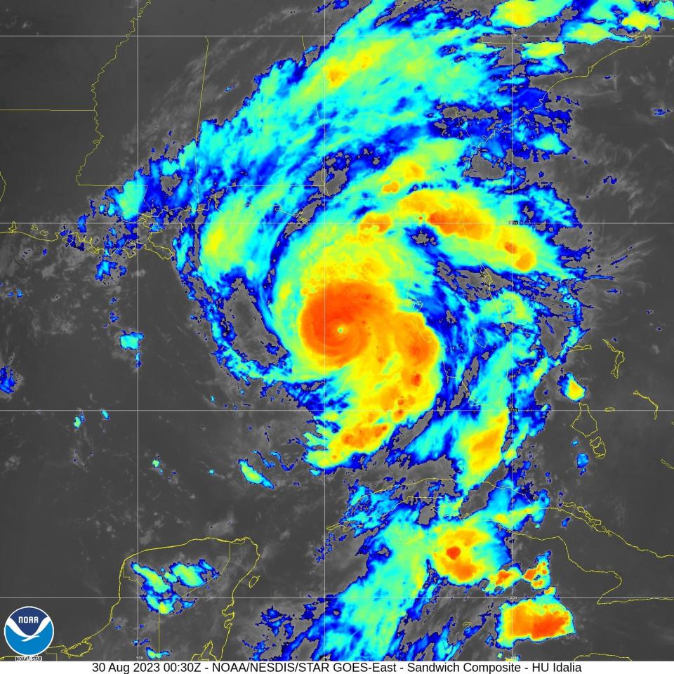
Official Idalia track remains unchanged; WeatherTiger sees landfall between Steinhatchee and St. Marks
The official forecast track for Hurricane Idalia didn’t change in the latest forecast from the National Hurricane Center in Miami.
The Hurricane Center still shows Idalia making landfall as perhaps a strong Category 3 storm somewhere near Steinhatchee, though it could potentially hit anywhere from the western Big Bend to north of Tampa Bay.
At 11 a.m. Tuesday, Idalia had maximum sustained winds of 120 mph and was located about 275 miles south-southwest of Tampa. It was moving north at 14 mph.
Leon, Wakulla, Jefferson and counties to the south and east are under a hurricane watch, meaning hurricane-force winds were expected within 36 hours — though the actual arrival time is much sooner.
Ryan Truchelut, chief meteorologist at Weather Tiger, said he expects Idalia to make landfall between 7 a.m. and noon Wednesday, most likely between Steinhatchee and St. Marks, though it could go as far west as Carrabelle and as far southeast as Cedar Key.
He said if Idalia follows a Hermine-like track, coming ashore around St. Marks, Tallahassee could find itself in the core of the storm.
“That would push our wind gusts into hurricane-force range at 90 or 100 mph or higher if we’re actually going straight through the middle of the core,” Truchelut said.
― Jeff Burlew
Franklin County issues mandatory evacuation for St. George Island
All barrier islands, low-lying areas, mobile homes and RV parks are under a mandatory evacuation notice in Franklin County, according to a Facebook post from the Franklin County Sheriff's Office. This includes residents and non-residents.
The rest of the county is under a voluntary evacuation notice.
The sheriff's office warns once the winds hit 45 mph, the bridges to Alligator Point and St. Georgie Island will close.
"If this route is compromised or closed, EMS or Responders will not be able to assist you. If you have life threatening medical conditions, please make arrangements now. Don’t Wait. Evacuate," the sheriff's office wrote.
Transportation to shelters in Leon County will be provided Tuesday only from the following locations:
Carrabelle Carrabelle Library 1 p.m.
Lanark Village Chillas Hall 1:15 p.m.
-Ana Goni-Lessan
Wakulla issues mandatory evacuation for coast
Wakulla County has now issued a mandatory evacuation order for coastal and low-lying areas as well as mobile homes, according to the Wakulla County Sheriff's Office. A voluntary evacuation order is in effect for the rest of the county.
There will be no shelters available in Wakulla County, the sheriff's office wrote in a Facebook post. Evacuees should head to Leon County to the following locations:
Fort Braden Elementary, 15100 Blountstown Hwy
Chiles High School, 7200 Lawton Chiles Lane
Rickards High School, 3013 Jim Lee Road
Lincoln High School, 3838 Trojan Trail
- Ana Goni-Lessan
Uber offering free rides to Florida shelters; pets allowed at Chiles
Uber announced Tuesday it will be offering free round-trip rides, up to $35 each way, to and from a state-approved evacuation shelter: Hernando, Hillsborough, Leon, Manatee, and Pinellas Counties. Redeem a free round trip, up to $35 each way, to and from a state-approved evacuation shelter by opening your app, tapping account, tapping wallet and scrolling to +Add Promo Code. Enter code IDALIARELIEF. Select any of the following Hernando, Hillsborough, Leon, Manatee, and Pinellas County, state-approved Florida evacuation shelters listed at floridadisaster.org/planprepare/shelters. Maximum discount of up to $35 per ride. Ride offer valid for up to two trips per rider.
The school district will open emergency shelters Tuesday evening at Chiles High School, Lincoln High School, Rickards High School and Fort Braden K-8 School. Pets will be allowed at Chiles.
- Martha Gruender
Depending on track, Hurricane Idalia could cause more damage in Tallahassee than Michael or Hermine
The odds that Hurricane Idalia could cause significant wind damage in Tallahassee and catastrophic surge over central and eastern Apalachee Bay increased overnight, according to meteorologist Ryan Truchelut.
Truchelut, chief meteorologist at WeatherTiger, noted in a Tuesday morning briefing for his substack subscribers that the National Hurricane Center’s official track shifted about 20 miles west overnight into Taylor County.
The change was due to overnight model guidance “some of which is now taking Idalia across central or even even western Apalachee Bay and then over or just east of Tallahassee.”
If that western guidance holds, Truchelut wrote, Tallahassee would get hit by the core of Idalia after landfall, which means wind gusts of 75 to 100 mph, “causing damage exceeding Hermine or Michael.”
“Additionally, life-threatening storm surge of 8-12 feet, now the peak range in eastern Apalachee Bay, would occur over much if not all of Apalachee Bay. This is absolutely a possibility and always has been, so you need to prepare as if it is going to happen.
― Jeff Burlew
A powerful Hurricane Idalia could be on Tallahassee's 'doorstep' by Wednesday morning; forecasters say today last day to prepare
The National Weather Service is warning everyone in Tallahassee to prepare for the possibility of hurricane-strength as Idalia’s track continued to shift west toward the central Big Bend overnight.
Wright Dobbs, meteorologist with the National Weather Service, said people in Tallahassee need to get their storm supplies ahead of a Wednesday morning landfall.
“Preparations need to be done today, especially once we see those rain bands come in and we see that tornado potential to increase in those outer rain bands Tuesday night and early Wednesday,” Dobbs said. “You’re not going to have time Wednesday morning to get things done, because Idalia is going to be right on our doorstep by sunrise on Wednesday.”
Dobbs said that on Tuesday, the Weather Service issued guidance that residents in southeast Leon County prepare for the possibility of hurricane force winds.
“But with the overnight update, and seeing a lot of the guidance shift a little bit west, we did up those impacts that people should prepare for,” Dobbs said. “And so now we’re recommending folks all across Leon County prepare for the potential for hurricane force winds and/or gusts.”
The Apalachee Bay from Gulf County to Dixie and Levy counties has never seen a Category 3 or higher hurricane, Dobbs said.
Tallahassee hasn’t seen hurricane-force winds in the modern era. Hurricane Michael in 2018 brought 71-mph gusts, just slightly below Category 1 strength. Hurricane Hermine in 2016 brought 64 mph gusts. Hurricane Kate in 1985 brought 68 mph gusts.
"To put this system into the historical context, there are NO major hurricanes in the historical dataset going backto 1851 that have tracked into Apalachee Bay. None," local forecasters wrote in a sobering morning forecast. "Don`t mess around with this. Follow the advice of your local emergency management."
Meanwhile, coast south of Tallahassee could see catastrophic storm surge of 8 to 12 feet from the Aucilla River at the Jefferson/Taylor county line southeast to the Chassahowitzka River; 5 to 8 feet from the Aucilla to the Ochlockonee River; 3-5 feet from the Ochlockonee to Indian Pass in Gulf County and 1 to 3 feet from Indian Pass to Mexico Beach.
-Jeff Burlew
Tallahassee on razor's edge of Hurricane Idalia
The National Weather Service - Tallahassee wants people to be paying close attention today.
The storm's current National Hurricane Center forecast track still takes it to the east of the tree-filled capital city, but that could change as models and the track have shifted further west overnight.
Don Van Dyke, a meteorologist with the National Weather Service in Tallahassee, said a Hurricane Warning could be hoisted for the capital city at the 11 a.m. advisory. That would trigger a Wireless Emergency Alert that would ring out from the phones of residents.
"Hurricane force wind gusts in Tallahassee would be terrible ... Most of the power out, downed trees everywhere," he said. "And that's the really important advisory. That's the last chance to get that out there so people can finalize their preparations."
State-level updates: Hurricane Idalia intensifies; 46 Florida counties under state of emergency
Van Dyke said the storm is an unprecedented threat as there has not been a recorded Category 3 or higher hurricane in Apalachee Bay in the historical record, going back to 1851.
"It is very rare for a major hurricane to be in this part of the northern Gulf," Van Dyke said.
While Tallahassee may have seen the occasional hurricane wind gust in hurricanes Michael, Hermine or Kate, the city has never been tested by a barrage of sustained hurricane force winds above 74 mph.
On the current track in which Tallahassee is under a Tropical Storm Warning, the city can expect at minimum tropical storm force gusts of 50 to 60 mph and 3 to 6 inches of rain.
"If it goes a little bit to the west it will get much much worse," Van Dyke said.
- William Hatfield
This article originally appeared on Tallahassee Democrat: Hurricane Idalia Tuesday updates for Tallahassee, Florida's Big Bend

