Idalia updates for Wilmington: Weather conditions improving as storm moves offshore
As Tropical Storm Idalia moves offshore, forecasters at the National Weather Service Office in Wilmington say the Wilmington area should see drier conditions, with winds leveling off by mid-day.
Now that the storm has passed, damage assessments are beginning. Rachel Zouzias, meteorologist with the National Weather Service Office in Wilmington, said the area experienced several possible tornadoes as Tropical Storm Idalia passed through the region Wednesday evening. At this time, those reports are still unconfirmed, but Zouzias said “several teams” are on the ground examining those areas and should be able to make a determination later today.
The Wilmington area also saw between four and six inches of rain. Rainfall totals ranged from 3.75 inches around Masonboro Island to as much just over six inches in the Green Swamp. Other record rainfall totals were 4.15 inches in Wilmington, 5.58 inches in Leland, and 3.77 inches in Bolivia.
Zouzias said the strongest recorded winds occurred offshore with a gust of 61 mph recorded at Federal Point and gusts of 56 mph measured at the sea buoys. Observations closer to shore ranged from 50 to 60 mph.
The area also experienced some flash flooding, but Zouzias said the area was fortunate that much pf the storm’s push occurred overnight when the tide was lower. Flooding in downtown Wilmington was measured at 6.68 inches, which Zouzias said is “moderate flooding,” and water levels reached just 7 feet at Johnnie Mercers Fishing Pier.
About 1,000 are without power in Pender, according to Tommy Batson, Pender's Emergency Management Director. He said flooding is expected there along the river early next week.
Alex Riley, spokesman for New Hanover County, is reporting "several thousand" Duke Energy customers are without power and there are some reports of downed trees with many of those already cleared. He added flooded has occurred in the "expected spots, but nothing outside of the norm."
The StarNews will only post new updates to this story if conditions change. For complete coverage of the storm click here.
6 a.m. Thursday Update
In the wee hours of the morning Thursday, the center of Tropical Storm Idalia moved over the Wilmington area bringing more wind and rain.
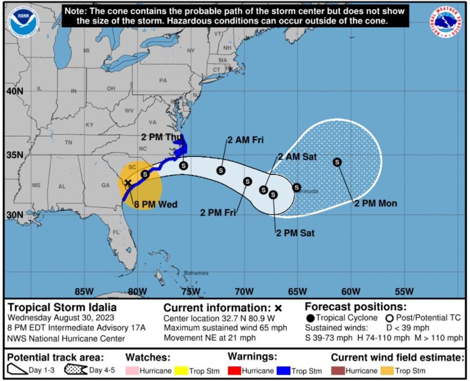
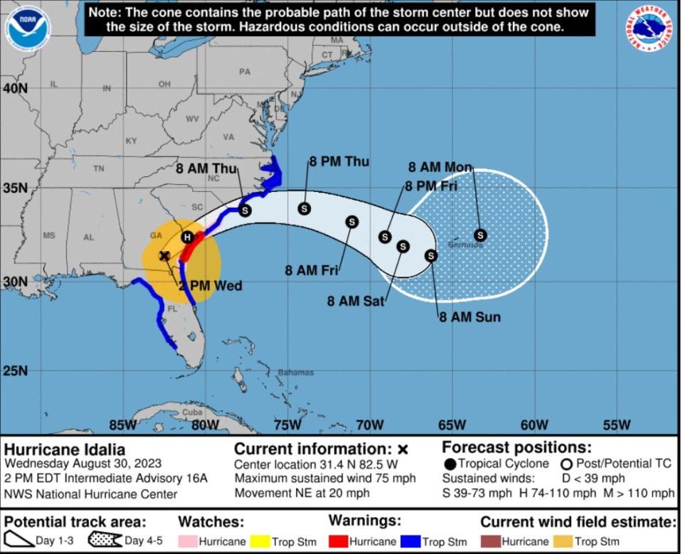
As of 5 a.m., the storm was moving to the east-northeast near 21 mph, and that general motion was expected to continue throughout the morning, Later this afternoon, the storm is expected to turn to the east-southeast and continue that path through Saturday. The center of Tropical Storm Idalia should move off the coast of North Carolina later today, and strong winds are expected throughout the day as tropical storm force winds extend up to 185 miles from the center of the storm.
At the 5 a.m. advisory, the storm remained at tropical storm strength with winds near 60 mph with higher gusts and little change in strength expected. Gradual weakening could occur Friday and Saturday.
The area remains under a tropical storm warning through 1 p.m.
The threat of flooding will continue as Idalia is expected to produce an additional two to four inches of rainfall across coastal North Carolina through the afternoon.
10 p.m. Wednesday update
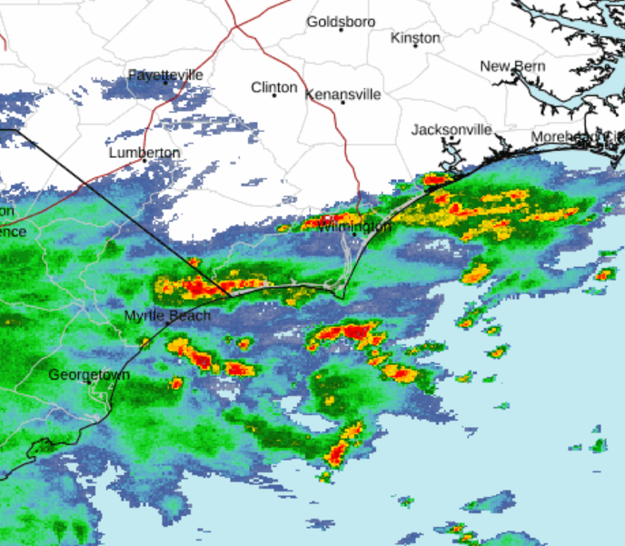
Heavy rain and high winds continue impacting the Cape Fear region late Wednesday night.
According to the National Weather Service, the area remains under a flood threat as Tropical Storm Idalia passes over the area. A coastal flood advisory was issued for inland New Hanover and Brunswick counties, specifically nearby the Cape Fear River in downtown Wilmington and inland Brunswick County.
The advisory remains in effect until 1 a.m. Thursday. Some downtown streets -- namely Water Street between Orange and Red Cross streets -- are expected to become impassable.
FLOODING: Some municipalities and neighborhoods across the tri-county area reported flooding as rainfall expedited Wednesday night. The bridge to Sunset Beach closed to motorists as high tide brought water across the causeway and made travel "impossible," according to the town's police department.
A flood advisory remains in effect until 1 a.m. Thursday for New Hanover and Brunswick counties. An estimated two to four inches of rain have fallen, with an additional two to four inches expected through the night.
THE LATEST: Complete coverage of Hurricane Idalia's impacts on the Wilmington area
8 p.m. Update: Winds, tornado activity hits Brunswick, New Hanover
The impacts of Tropical Storm Idalia became more severe early Wednesday night.
According to a 7:45 p.m. update from the National Weather Service, Brunswick and New Hanover counties saw severe thunderstorms moving northbound at 25 mph. Radar picked up rotational activity and the impact from these tornadic storms were felt in Wilmington, Leland, Belville and Navassa, the National Weather Service indicated.
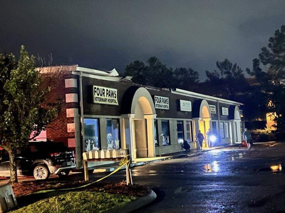
DAMAGE: Some damage has already been reported, namely in Brunswick County. According to social media reports, Four Paws Animal Hospital located on N.C. 211 sustained damage during the storm.
In a Facebook post, veterinarian Audra Rickman said part of the clinic's roof was "gone" and part of the ceiling inside collapsed. Rickman added that the hospital does not board and its two clinic cats are safe.
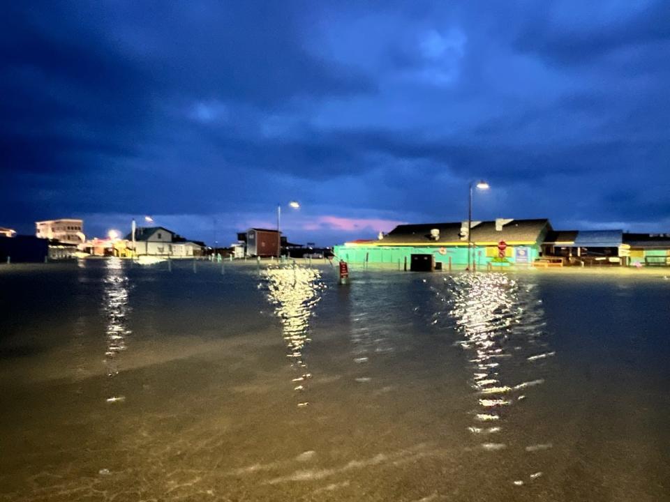
The webcam at Fishy Fishy Cafe in Southport shows the restaurant's parking lot mostly underwater as heavy rain impacts the area.
5 p.m. Update: Flooding, tornadoes possible through Wednesday evening
As Idalia has been downgraded to a tropical storm, flooding and tornadoes remain the largest threat to the Wilmington area, according to the National Weather Service.
According to a 5 p.m. update, rain from the storm is expected to impact Southeastern North Carolina through Wednesday night and into Thursday. The National Weather Service said the heaviest rainfall -- and largest potential for flooding -- is anticipated overnight.
The risk of tornadoes remains, officials said, with the greatest potential Wednesday evening. Brunswick, New Hanover and Pender counties remain at an enhanced risk for tornadoes as Idalia's outer rainbands move through the area.
3:30 p.m. Update: Worst of storm expected Thursday morning
The Cape Fear region began feeling the effects of Hurricane Idalia Wednesday as clouds, rain and wind impacted the tri-county area, but New Hanover County officials said the area hasn't seen the worst of the storm yet.
Steven Still, director of emergency management for New Hanover County, said in a news conference Wednesday afternoon that the county expects to see severe weather conditions through Wednesday night, with the most impact expected around 7:30 a.m. Thursday.
Still said current forecasts predict the storm to pass some 15 miles off the coast of New Hanover County, bringing 34 mph winds and gusts up to 40 mph Thursday morning. The county announced it will delay the openings of its offices and other facilities until 12:30 p.m. Thursday to avoid encouraging employees from driving during the peak impact of the storm.
With just three to four inches of rain expected in the county, Still reiterated that wind remains the biggest threat. However, Still added that any amount of rain can still cause flooding and pooling of water on roads, so use caution when driving.
INEXPERIENCED SWIMMERS: With the holiday weekend approaching, Still said inexperienced swimmers are asked to avoid swimming in the ocean ahead of the storm, due to an increased risk of rip currents and rough waters.
2 p.m. Update: Tornado threat increases
With Hurricane Idalia creeping across Georgia and toward North Carolina, the Cape Fear region saw mostly cloudy conditions through the early afternoon Wednesday with some rain showers. According to a 2 p.m. update from the National Hurricane Center, Hurricane Idalia is currently located over southeastern Georgia.
According to the National Weather Service in Wilmington, impacts from the storm are expected to increase through Wednesday evening, with an increased threat of tornado activity between 4 p.m. and 10 p.m. Tornadoes, heavy rain, flooding and strong winds are expected.
TROPICAL STORM WARNING: The National Weather Service issued a tropical storm warning for coastal areas of Brunswick, New Hanover and Pender counties, upgrading the advisory from a tropical storm watch earlier today.
WIND: Heavy wind is expected Wednesday, especially along the coast and across coastal waters.
11 a.m. Update: Idalia brings high winds into Georgia
As of 11 a.m., Hurricane Idalia crossed into Georgia with winds of around 90 mph. Although Hurricane Idalia reached a Category 4 intensity early this morning, it had decreased to Category 3 strength when it made landfall near Keaton Beach, Florida at around 8 a.m.
The current track shows the center moving near the coasts of Georgia, South Carolina and North Carolina through Thursday and should become a tropical storm by tonight while moving near the coast of South Carolina, according to the National Hurricane Center.
DOWNGRADE: Idalia is still considered a hurricane, but it is weakening, according to the center. It’s still considered a dangerous storm as it moves over Georgia with winds of 90 mph and higher gusts.
STORM SURGE: Hurricane Idalia is causing significant storm surge in Florida and Georgia. Dangerous storm surge is also expected along the southeastern U.S. coast, especially during high tides around 8 p.m. Wednesday and 8 a.m. Thursday.
COASTAL FLOODING: The National Weather Service in Wilmington has issued an advisory for coastal New Hanover, Pender and Brunswick counties. Inundation of up to one half foot above ground level is expected in low-lying areas near shorelines and tidal waterways. There’s also a High Surf Advisory, in effect from 8 p.m. through 8 p.m. Thursday, indicating large breaking waves of 6 to 9 feet. The Coastal Flood Advisory is in effect from 6 to 10 p.m. High rip current risks remains in effect through Thursday,
9 a.m. Update: Rain bands reach NC coast
As of 9 a.m., rain and thunderstorms from the outer bands of Hurricane Idalia had arrived in the Wilmington area, with the National Weather Service in Wilmington reporting storm conditions at the Wilmington International Airport.
Hurricane Idalia was located near Madison, Florida, and was approaching Valdosta, Georgia. Maximum sustained winds were near 110 mph with higher gusts.
Here's a look at what we can expect in the Wilmington area, according to the latest briefing from the National Weather Service:
RAIN: There is a heavy rain threat for the Wilmington area, according to the National Weather Service. Earlier this morning, the total expected rain amount was increased to as much as 10 inches. While showers and storms have already started in the area, the heaviest rainfall, and potential for flooding, is likely to occur this evening and overnight.
WIND: The NWS has also announced a Tornado Threat as the outer bands of Hurricane Idalia could produce tornadoes or waterspouts. The highest chance for this is along the Brunswick County coast and Cape Fear from 4-10 p.m.
TRACK THE STORM: See the latest updates on the path of Hurricane Idalia.
8 a.m. Update: Idalia makes landfall in Florida
Hurricane Idalia made landfall around 8 a.m. Wednesday near Keaton Beach along the Florida coast. The storm had intensified into a Category 4 storm, but was downgraded to Category 3 just before landfall. Maximum sustained winds were 120 mph, with catastrophic storm surge expected.
Forecasters are now also expecting an increased impact to the Wilmington area, with more rainfall and stronger winds. The region will start experiencing rain and wind bands from Idalia as the day progresses Wednesday. The heaviest rainfall and winds are expected Wednesday night into Thursday morning.
The National Weather Service issued a tropical storm warning for Southeastern North Carolina at 5 p.m. Tuesday, which means tropical storm conditions are possible within 36 hours.
Live updates from Florida: Hurricane Idalia makes Florida landfall with winds at 125 mph
5 a.m. Update: NC under state of emergency as Idalia approaches
N.C. Gov. Roy Cooper declared a state of emergency Tuesday to activate the state’s emergency operations plan.
"We are continuing to monitor Idalia’s course and its potential impacts on our state and it’s critical to make sure we are fully prepared," Cooper said in a news release. "It is important for North Carolinians to gather emergency kits and prepare for the storm before it’s too late."
Here's a look at what we can expect in the Wilmington area, according to the latest briefing from the National Weather Service:
WIND: Tropical storm force winds (over 40 mph) are likely for parts of the region. Downed trees and isolated power outages are possible. Winds will probably be highest Wednesday night and Thursday morning, with sustained winds of 35 to 45 mph and gusts as high as 60 mph. Tornadoes and waterspouts are possible.
RAIN: Heavy rain and flash flooding are likely. The latest briefing said the area could see between 8 and 10 inches of rain, which will likely result in some flooding in low-lying areas and places with poor drainage. Road closures are possible. Heaviest rain is expected to be Wednesday night and Thursday morning.
STORM SURGE: The briefing said there's also "potential for some storm surge" and coastal inundation, especially during high tides around 8 p.m. Wednesday and 8 a.m. Thursday. Overall, storm surge inundation of 1 to3 feet above ground level is expected. Any storm surge impacts are likely to be limited.
MARINE: Maritime conditions will continue to be hazardous, due not only to Idalia, but also to Hurricane Franklin, a major hurricane off the Atlantic Coast. The risk of dangerous rip currents is expected to last through the end of the week.
More Hurricane Idalia Coverage
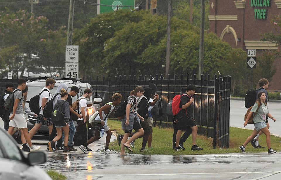
SCHOOLS: Schools closing in the Wilmington area due to Hurricane Idalia
FLOODING: King Tides expected as Hurricanes Franklin, Idalia threaten Wilmington-area beaches
HOW TO PREPARE: Supplies, shelters, evacuations and more
HISTORY: What are the 5 worst hurricanes to ever hit the Wilmington area?
This article originally appeared on Wilmington StarNews: Hurricane Idalia live updates for Wilmington, NC coast

