Tornadoes wreak extensive damage in eastern Iowa; at least 40 structures damaged in Johnson County
- Oops!Something went wrong.Please try again later.
At least eight tornadoes were spotted across Iowa Friday as large swaths of the southeastern portion of the state reported extensive damage to homes and buildings in a massive storm front that killed more than two-dozen people across the nation.
The National Weather Service has confirmed at least eight tornadoes based on preliminary data, including a low-end EF4 that tracked from Wapello into Johnson County; five EF2 tornadoes, one in Cedar county into Clinton County, one in Clinton County, two in Johnson county and one in Des Moines County; and two tornadoes in Jackson county, one EF1 tornado that began in Jackson County before moving to Illinois and another EF0 stayed in county lines.
The total number of tornadoes is expected to rise.
[1/4] Good Afternoon Folks. Current count is 10 confirmed tornadoes, with ongoing surveys and still many to go. Please be patient with us, as this will continue for the next few days!
— NWS Quad Cities (@NWSQuadCities) April 2, 2023
The EF scale uses wind estimates based on damage and calculates 3-second gusts estimated at the point of damage, according to the NWS. EF4 tornadoes bring gusts of 166 to 200 mph; EF3, 136 to 165; EF2, 111 to 135; and EF1, 86 to 110.
Coralville and Hills in Johnson County were among the towns that saw extensive damage, and part of Charlotte in Clinton County was evacuated because of a propane leak.
The Iowa storms were part of a powerful system of storms and tornadoes that tore through the South and Midwest starting Friday. By Sunday morning, the death toll nationally had risen to 26.
More: 'Where are my kids going to stay?': Storm damage leaves some Coralville families homeless
NWS to have official tornado count Monday; at least 40 structures damaged in Corallville and Hills
National Weather Service officials in Davenport are still working on the official tornado count, a number that will most likely be available Monday morning, the NWS said. The latest tornadoes added are the two surveyed near the town of Solon. Survey teams have preliminarily rated those both as EF2, according to NWS Quad Cities.
David Wilson, director of Johnson County Homeland Security and Emergency, said 20 buildings and homes were damaged in Coralville, along with another 20 in Hills but believes the total will be north of 60 structures. Other numbers will be available later Sunday afternoon, he said. 118 calls were placed to 911 during the event.
EF4 tornado confirmed; it tracked from Wapello to Johnson County
Preliminary data has led to a low-end EF4 rating for a tornado that tracked from Wapello into Johnson County, with maximum estimated winds at about 170 mph and maximum width of 600 yards, according to the National Weather Service.
More: 9 possible tornadoes tallied in eastern Iowa Friday from 'strong and unusual storm system'
EF1 tornado confirmed in Bellevue
Preliminary data shows an EF1 tornado crossed over Bellevue before heading over the Mississippi River, according to the National Weather Service.
🌪️Preliminary EF1 rating for the tornado that impacted the Bellevue IA area before crossing the Mississippi River. #iawx
— NWS Quad Cities (@NWSQuadCities) April 1, 2023
EF2 tornado confirmed in Clinton County
The National Weather Service confirmed an EF2 tornado touched down in Clinton County, moving northeast from Grand Mound through Charlotte.
🌪️Preliminary EF2 rating for the tornado that tracked from Grand Mound through Charlotte, IA. #iawx
— NWS Quad Cities (@NWSQuadCities) April 1, 2023
Gov. Kim Reynolds signs disaster proclamation for 12 counties
Iowa Gov. Kim Reynolds signed a disaster relief proclamation on Saturday morning for 12 counties in eastern Iowa in the wake of the storm damage.
The proclamation intends to "ease restrictions on the transportation of materials related to disaster response and repairs," according to a press release. Those measures include temporarily suspending restrictions on hours of service for disaster relief crews and movement of loads on highways to help in disaster recovery.
The counties included in the proclamation are Cedar, Clinton, Delaware, Des Moines, Dubuque, Grundy, Johnson, Keokuk, Linn, Mahaska, Wapello and Washington.
The Iowa Individual Assistance Grant Program is now also available for residents of those counties impacted by the disaster whose household annual income is at 200% or less than the federal poverty level. Households may receive up to $5,000 to assist in disaster recovery such as home or car repairs, food, clothing and other recovery expenses. Individuals have until May 16 to apply through the Iowa Department of Health and Human Services website.
Residents of the counties of any income bracket can also receive assistance through the Disaster Case Management Program. Care is organized through local community action associations.
The proclamation is in effect from April 1 to May 1.
More: How to claim tornado relief in Iowa if your house or property has been damaged
National Weather Service warns of more severe weather next week
The National Weather Service warned that another round of severe weather could hit central and eastern Iowa on Tuesday.
Southeastern Iowa is particularly at risk of tornadoes, damaging winds and large hail, the organization wrote on Twitter.
The potential for another round of severe weather is increasing on Tuesday afternoon and evening. The greatest threat is over the southeast third of Iowa where all modes of severe weather will exist. Be weather aware on Tuesday and have a plan to take shelter if necessary! #iawx pic.twitter.com/VA5EFqoI9D
— NWS Des Moines (@NWSDesMoines) April 1, 2023
EF3 tornado confirmed near Keota
Preliminary data confirms an E3 tornado touched down near Keota on Friday, according to The National Weather Service.
🌪️Preliminary EF3 rating for tornado near Keota, IA. Survey still ongoing. #iawx
— NWS Quad Cities (@NWSQuadCities) April 1, 2023
Here’s a video clip from the large tornado northeast of Keota, Iowa, earlier this afternoon. The farm house was untouched, but I heard later a nearby barn was damaged. #iawx #midwesttornadoes pic.twitter.com/dgNsZovpuu
— Bryon Houlgrave (@bryonhoulgrave) March 31, 2023
Charlotte propane tank leak contained; one family rescued from fallen home in Clinton County
Officials quickly repaired a leak in a 10,000-gallon propane tank in northern Charlotte Friday night, which had required half of the town's residents to evacuate. Residents were able to return to their homes last night, according to Clinton County Emergency Management Coordinator Chance Kness.
Kness said several homes across the county were destroyed by the strong storms. He said eyewitness accounts confirmed at least one tornado touched down in the county, but his team is awaiting confirmation from the National Weather Service.
Emergency personnel rescued a family of three trapped in their collapsed home north of Grand Mound last night at 6 p.m., Kness said. One of the residents was transported to Genesis Medical Center in DeWitt for their injuries, he said.
Kness said emergency personnel worked efficiently to survey damage and respond to calls for service in the county, thanks in large part to early warnings ahead of the storm.
"Because of the extremely early warning about the severity of this event, we had staffed our Emergency Operations Center, notified responders," he said. "We're very fortunate in Clinton County to have excellent first response capabilities and great working relationships. I feel like everything went very smoothly."
EF3 tornado confirmed outside Hedrick
The National Weather Service out of the Quad Cities confirmed preliminary data shows an EF3 tornado touched down three to five miles away from Hedrick in Keokuk County.
Preliminary EF-3 damage 3 to 5 miles east of Hedrick Iowa. More details to come later today.
— NWS Quad Cities (@NWSQuadCities) April 1, 2023
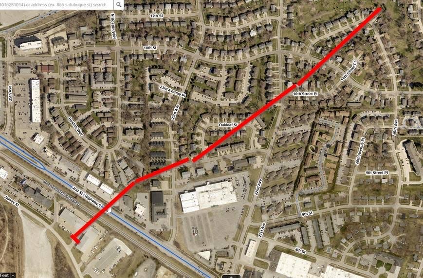
Insulation, debris line grass on 23rd Street in Coralville
Dozens of community members, including Coralville Mayor Meghann Foster and Iowa City Community School District employees, lined 23rd Street in Coralville Saturday morning to help clear out debris.
“We have a lot of people that want to step up and help,” Foster said.
Here on 23rd Street in Coralville where dozens of community members, including folks from the Iowa City Community School District, are helping clear out debris. Coralville mayor Meghann Foster is here as well. “We have a lot of people that want to step up and help,” she said. pic.twitter.com/FlnezlOuh8
— Paris (@ParisBarraza) April 1, 2023
On Ninth Street, insulation littered the grass in front of people's homes. From afar, it looked almost like snow.
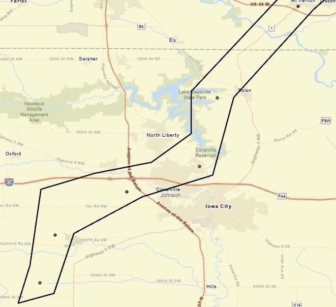
EF2 tornado confirmed in Johnson County
The National Weather Service based in the Quad Cities has confirmed one EF-2 tornado touched down in Johnson County Friday near Hills. Johnson County Emergency Management Coordinator Dave Wilson said there may have been up to three tornadoes that hit the county.
🌪We have a preliminary EF2 rating for the tornado in Hills, Iowa yesterday. More details to come later today. #iawx
— NWS Quad Cities (@NWSQuadCities) April 1, 2023
The tornadoes first were sighted in the southwest corner of the county, in Frytown, and made their way up through the west side of Hills, he said.
In Hills, "about a six-block-wide area between Highway 218 and the railroad tracks" sustained notable damage, he said. The area is made up of apartment buildings, a few individual residences and commercial storage sheds, he said.
From there, the storm moved to the west of Iowa City over the city's landfill and ended up in Coralville, where a portion of four blocks stretching from Highway 6 to Boston Way sustained damage, he said. The storm then "hopped up" to Solon, Wilson said, where it damaged a new subdivision under construction and took the roof off a local hardware store and Mexican restaurant. Wilson reported "scattered damage" throughout smaller towns and rural areas in the county.
Local power companies helped restore power to the majority of buildings, and the county was able to reopen all roadways by midnight Friday, Wilson said.
The county helped shelter 11 individuals following the storm: Eight stayed at the Red Cross-run shelter at the Coralville Recreation Center, and three stayed in an off-site location for "medical special needs," Wilson said. All three at the off-site location had departed as of 8:30 a.m.
Across the county, only two minor injuries were reported, he said, and there were no fatalities or reports of anyone trapped. Officials responded to 118 calls for service as of 8 a.m. Saturday morning, including 14 for public assistance, six for a gas line break, five for rescue and 24 for road hazards, according to data provided by Wilson.
Eight Johnson County residents spend night in shelter after storms destroyed homes
Eight Johnson County residents spent the night at the Coralville Recreation Center after a series of storms and potential tornadoes ripped through the region and destroyed their homes.
Mamie Kahulumbanda, her two daughters, son, husband and younger brother lost their home due to yesterday’s tornado. Her daughter, Precieuse, said they are “traumatized.”
“We have nothing besides our car,” she said.
Angla and Robert Manning spent the evening at a hotel last night after their home was destroyed. Angla would have been home when the tornado hit, but had to run an errand at Walmart and remained there during the storm. “It was a blessing that we weren’t home,” she said.
The Red Cross ran the shelter, which provided residents with blankets, teddy bears and hygiene bags including toothbrushes.
Blankets, hygiene bags including toothbrushes and teddy bears are just some of the things available to folks here at the Coralville Recreation Center. pic.twitter.com/nWClHONSBe
— Paris (@ParisBarraza) April 1, 2023
Coralville sets up emergency shelter for those displaced after the storm
The Coralville Recreation Center at 1506 Eighth Street will serve as an emergency shelter for those who are displaced by the storm, according to Mayor Meghann Foster.
Red Cross staff and volunteers will be there to assist residents at the shelter, she said.
"If anybody is interested or needs that help, they can call the Johnson County Emergency Dispatch, and they will get them connected to the right people," Foster said.
City of Charlotte evacuates half of the town from propane tank leak
In the wake of the storms, emergency service personnel discovered a leaking 10,000-gallon propane tank on the north side of Charlotte in Clinton County.
City Auditor and Public Information Officer Eric VanLancker said concerns over strong winds prompted the city to evacuate half of the town of just under 400 people.
Davenport Hazmat is assisting the city and other emergency officials with repairing the leak, which VanLancker said the city hoped would be completed by Friday night.
Those who could not shelter with other family and friends were evacuated to the Lutheran Church on the south side of the town, VanLancker said.
Coralville Mayor said minor injuries reported, no fatalities
Coralville Mayor Foster said minor injuries have been reported so far after an apparent tornado tore through the city and left considerable damage in its wake.
"As of right now, we're not hearing of any fatalities, which is something we are very grateful for and hopefully, that continues to be the trend that we are seeing," she said.
She said first responders are out helping to clear debris and ensure residents are safe and accounted for. Gas lines in certain parts of the city have been turned off as a precaution while the damage is assessed, she said.
A vehicle with a light tower is being placed near the Subway on Highway 6.
"We've got quite a bit of damage in the community right now," she said. "And it's really important that we're letting the first responders clear away that debris and get everything settled."
She said the city is working on setting up a shelter for those whose homes have been severely damaged or lost due to the tornado. More information on the shelter will be released as it becomes available, she said.
Hundreds help neighbors with damage in Hills
Photos from Hills, Iowa. #iawx
Community members are working to salvage their personal belongings after a storm damaged homes on the north west side of town. @presscitizen @DMRegister Updates: https://t.co/l0819G84Mf pic.twitter.com/hQIEjnZdpZ— Joseph Cress (@josephwcress) April 1, 2023
Hundreds of residents of Hills came out to help each other after an apparent tornado barreled through the town, ripping off roofs and leaving a trail of debris in its path.
Hundreds of people are here in Hills helping their neighbors after the town sustained heavy damage. @presscitizen @DMRegister #iawx pic.twitter.com/tzB47CRRAU
— Joseph Cress (@josephwcress) March 31, 2023
Insulation covered nearly two city blocks on the northwest side of Hills from Casey's to the edge of town, with other buildings damaged along the way.
Buildings flattened, roads blocked by fallen trees in Coralville
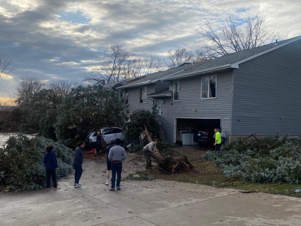
Families and neighbors gathered along a row of houses on 23rd Street in Coralville Friday afternoon to assess the damage from a tornado that rolled through the region.
Downed trees and power lines riddled streets and driveways next to homes which sustained major damage.
Just past the street, downed trees were blocking Highway 6. An apartment building off Boston Way was flattened next to a semi-truck flipped onto its back.
The branches of trees left standing were riddled with debris from nearby buildings and homes.
Coralville resident Gordon Knight said he watched from the window of his basement apartment as the building's siding started flying away amid the gusting winds and heavy rainfall. Within minutes, he saw the roof of a neighboring building torn off. In the parking lot, a tree fell onto one of the resident's cars.
"I've lived in Iowa about 50 years and that's the closest I ever came to a tornado," he said.
While the exterior of his apartment building sustained notable damage, he said all of the residents inside were safe and didn't suffer any injuries.
Des Moines clear of severe weather, but gusty winds still expected
As of 7 p.m., there were no more severe storms forecasted for Des Moines and central Iowa Friday evening. However, the National Weather Service warned residents should still expect "strong gusty winds" while those up north are likely to experience snow.
Storm's have moved out of central IA and no more severe weather is expected in the forecast area this evening.
However, the busy weather day isn't quite done as strong gusty winds have begun to develop over the area. Light snow is also expected across the north tonight.💨❄️— NWS Des Moines (@NWSDesMoines) March 31, 2023
Tornado warning issued in De Witt, Preston and Charlotte
A tornado warning is in effect following an observed tornado in the regions of De Witt, Preston and Charlotte. The warning is in effect until 6:45 p.m. and there is no hail expected.
Tornado Warning including De Witt IA, Preston IA and Charlotte IA until 6:45 PM CDT pic.twitter.com/uvouRv3UNs
— NWS Quad Cities (@NWSQuadCities) March 31, 2023
Tornado warning issued for Wyoming, Oxford Junction and Lost Nation
A tornado was seen in the region of Wyoming, Oxford and Lost Nation. A warning is in effect in the area until 6:30 p.m., during which the region may experience up to golf-ball-sized hail.
Tornado Warning including Wyoming IA, Oxford Junction IA and Lost Nation IA until 6:30 PM CDT pic.twitter.com/UbrbTQSi59
— NWS Quad Cities (@NWSQuadCities) March 31, 2023
Tornado warning issued for Lowden, Wheatland and Delmar
An observed tornado triggered a tornado warning in the areas around Lowden, Wheatland and Delmar. The warning is in effect until 6:15 p.m. No hail is expected in the area.
Tornado Warning including Lowden IA, Wheatland IA and Delmar IA until 6:15 PM CDT pic.twitter.com/7hikoRWbcJ
— NWS Quad Cities (@NWSQuadCities) March 31, 2023
Tornado warning issued for Manchester, Earlville and Delhi
The National Weather Service issued a tornado warning for the regions around Manchester, Earlville and Delhi until 6:15 p.m. The region could experience quarter-sized hail.
Tornado Warning including Manchester IA, Earlville IA and Delhi IA until 6:15 PM CDT pic.twitter.com/TpPhlMl7EO
— NWS Quad Cities (@NWSQuadCities) March 31, 2023
Tornado warning issued for Tipton, Mechanicsville and Clarence
A tornado warning is in effect for the regions around Tipton, Mechanicsville and Clarence until 5:45 p.m. Golf-ball-sized hail is possible in the region. As of 5:30 p.m., the threat was raised from an observed tornado to a "damaging tornado."
A further warning was issued for Clarence, Olin and Stanwood until 5:45 p.m. also described as a "damaging tornado."
Tornado Warning continues for Tipton IA, Mechanicsville IA and Clarence IA until 5:45 PM CDT pic.twitter.com/8AouIz57XF
— NWS Quad Cities (@NWSQuadCities) March 31, 2023
Tornado warning issued for Wilton, Durant and Bennett
A tornado warning is in effect for Wilton, Durant and Bennett until 6 p.m. Pea-sized hail is possible.
Tornado Warning including Wilton IA, Durant IA and Bennett IA until 6:00 PM CDT pic.twitter.com/jf7toMLmpS
— NWS Quad Cities (@NWSQuadCities) March 31, 2023
Tornado warning issued for Anamosa, Mount Vernon and Lisbon
A tornado warning is in effect in Anamosa, Mount Vernon and Lisbon until 5:45 p.m. The region could see up to golf ball-sized hail.
As of 5:40 p.m., the warning was extended to 6:15 p.m. to include the regions around Anamosa, Dyersville and Monticello.
Tornado Warning including Anamosa IA, Dyersville IA and Monticello IA until 6:15 PM CDT pic.twitter.com/4YIEVQoL56
— NWS Quad Cities (@NWSQuadCities) March 31, 2023
Tornado warning issued for West Liberty, West Branch, Rochester
The National Weather Service issued a tornado warning for the region of West Liberty, West Branch and Rochester, just outside of Iowa City. The warning is in effect until 5:30 p.m. and the region could see ping-pong-sized hail.
Tornado Warning including West Liberty IA, West Branch IA and Rochester IA until 5:30 PM CDT pic.twitter.com/utiDO7i7v7
— NWS Quad Cities (@NWSQuadCities) March 31, 2023
Tornado warning issued for Fairfield, Mount Pleasant and Wayland
A tornado warning in Fairfield, Mount Pleasant and Wayland is in effect until 5:30 p.m. Ping-pong-sized hail is possible.
Tornado Warning including Fairfield IA, Mount Pleasant IA and Wayland IA until 5:30 PM CDT pic.twitter.com/CS5ChrhFM0
— NWS Quad Cities (@NWSQuadCities) March 31, 2023
Tornado warning issued for Vinton, Center Point and Urbana
A tornado warning is in effect in Vinton, Center Point and Urbana until 5:30 p.m. Quarter-sized hail is possible.
Tornado Warning including Vinton IA, Center Point IA and Urbana IA until 5:30 PM CDT pic.twitter.com/hgTayS3sbC
— NWS Quad Cities (@NWSQuadCities) March 31, 2023
Tornado warning issued for Waterloo and surrounding areas
A tornado warning is in effect in Waterloo, Cedar Falls and Grundy Center until 5:15 p.m. Pea-sized hail is possible in the region.
Tornado Warning including Waterloo IA, Cedar Falls IA and Grundy Center IA until 5:15 PM CDT pic.twitter.com/cM9PJwOFMC
— NWS Des Moines (@NWSDesMoines) March 31, 2023
Tornado warning issued for Washington, Kalona and Riverside
A tornado warning for Washington, Kalona and Riverside is in effect until 5 p.m. The region could experience ping-pong-sized hail as storms move through.
Tornado Warning including Washington IA, Kalona IA and Riverside IA until 5:00 PM CDT pic.twitter.com/Mf6bGVX9T9
— NWS Quad Cities (@NWSQuadCities) March 31, 2023
Tornado warning issued for Coralville and surrounding areas
The National Weather Service declared a tornado warning for Coralville, North Liberty and Mount Vernon until 5:15 p.m. Baseball-sized hail is possible in the region.
Tornado Warning including Coralville IA, North Liberty IA and Mount Vernon IA until 5:15 PM CDT pic.twitter.com/RSTwWNL0eT
— NWS Quad Cities (@NWSQuadCities) March 31, 2023
Tornado warning issued for Marshalltown and surrounding areas
A tornado warning is in effect for Marshalltown, Reinbeck, and Gladbrook.
The warning is in effect until 5:15 p.m. and those in the area could see up to pea-sized hail.
Tornado Warning including Marshalltown IA, Reinbeck IA and Gladbrook IA until 5:15 PM CDT pic.twitter.com/VSqmgcSsWY
— NWS Des Moines (@NWSDesMoines) March 31, 2023
Tornado warning issued for Waverly, Parkersburg and Ackley
A tornado warning is in effect for Waverly, Parkersburg and Ackley, located just east of Iowa Falls.
The warning is in effect until 5:15 p.m. and those in the area could see up to pea-sized hail.
Tornado Warning including Waverly IA, Parkersburg IA and Ackley IA until 5:15 PM CDT pic.twitter.com/TIt1kdl1yH
— NWS Des Moines (@NWSDesMoines) March 31, 2023
Central Iowa no longer under severe weather threat as storms head east
Severe thunderstorms with a history of producing large hail and tornadoes continue to impact the eastern portions of the area.
The severe threat has ended for those behind the second line of storms. However, strong, gusty winds may continue.
#iawx pic.twitter.com/FXYwH6S21W— NWS Des Moines (@NWSDesMoines) March 31, 2023
Central Iowa is no longer considered to be under threat of severe weather as storms with large hail and tornadoes continue to rock parts of eastern Iowa.
The National Weather Service said storms and gusty winds may continue in central Iowa. Eastern Iowa continues to be impacted by severe weather.
Tornado warning issued in Benton County
A tornado warning was in effect in Vinton, Garrison and Mount Auburn, all located in Benton County. The warning is radar-indicated and the region may see up to pea-sized hail.
The warning expired at 4:45 p.m.
Tornado Warning including Vinton IA, Garrison IA and Mount Auburn IA until 4:45 PM CDT pic.twitter.com/aZxwlNHruW
— NWS Quad Cities (@NWSQuadCities) March 31, 2023
Tornado warning issued in parts of Iowa, Washington Counties
A tornado warning has been issued for Williamsburg, Wellman and North English located in Iowa and Washington Counties. Baseball-sized hail is possible. The warning expired at 4:45 p.m.
Tornado Warning including Williamsburg IA, Wellman IA and North English IA until 4:45 PM CDT pic.twitter.com/qf6sTfcObw
— NWS Quad Cities (@NWSQuadCities) March 31, 2023
Tornado confirmed near Jefferson, Keokuk Counties
A large and dangerous tornado is on the ground in Keokuk County, according to the National Weather Service.
The tornado touched down near Packwood in Jefferson County and is headed toward Hedrick and Martinsburg in Keokuk County.
Tornado on the ground heading for Hedrick and Martinsburg. Take cover now! https://t.co/1JG1U6ySMB
— NWS Quad Cities (@NWSQuadCities) March 31, 2023
All those in the area should take cover now.
Tornado warning issued for Tama, Toledo and Chelsea
A radar-indicated tornado warning has been issued for Tama, Toledo and Chelsea, located in between Des Moines and Cedar Rapids. Pea sized hail is possible as a storm rolls through the region.
The warning expired at 4:45 p.m.
A severe thunderstorm warning has also been issued for the region, including Grinnell.
Tornado spotted Montezuma
A tornado has been spotted near Malcom and Montezuma, according to the National Weather Service.
Big stovepipe #tornado in progress near Malcom, Iowa. #IAwx @NWSDesMoines pic.twitter.com/YDjFDBdwha
— Nick Stewart (@NStewCBS2) March 31, 2023
The warning for this area was allowed to expire as storms move east.
Tornado confirmed near Ottumwa
The National Weather Service confirmed a tornado touched down just northeast of Ottumwa.
Confirmed tornado just northeast of Ottumwa. #IAwx https://t.co/dheUUBGVc4
— NWS Des Moines (@NWSDesMoines) March 31, 2023
The tornado warning for this area has expired, but it remains under a severe thunderstorm warning.
Anyone in the area should take cover now.
Large hail reported across the state
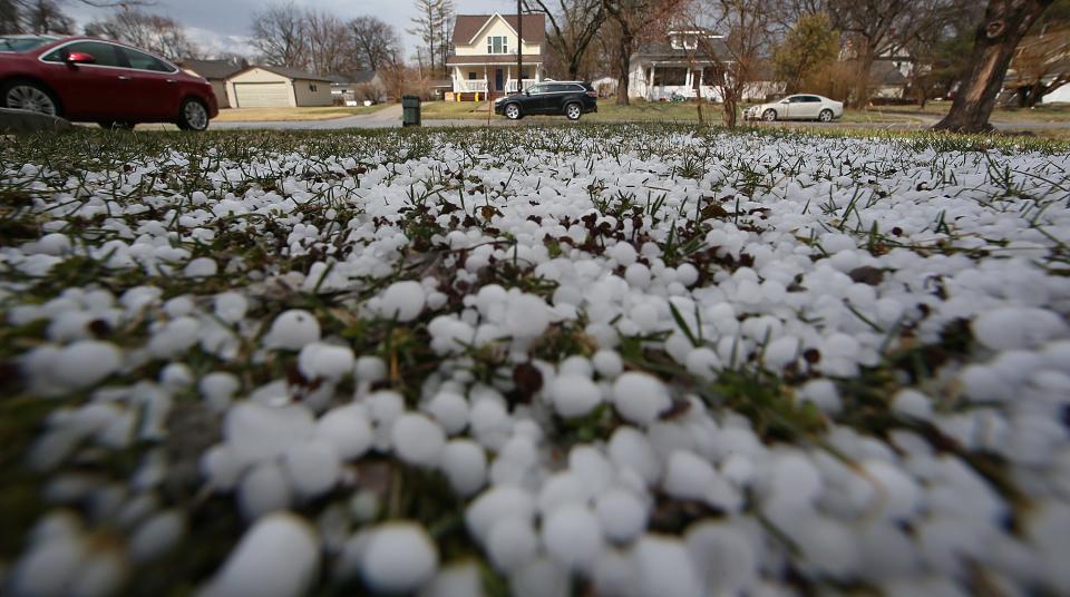
Storms moving across Iowa dropped large hail. The National Weather Service reported a cell moving through Story County around 3 p.m. produced hail as large as 2 inches in diameter.
West side of Ames hail. #iawx @NWSDesMoines pic.twitter.com/rq6zS3SxQS
— Michael Gens (@mikegens) March 31, 2023
What should you do during a tornado warning?
The weather service says it's always important to have an emergency plan in place in the event of severe weather, including designating a "safe place" in your home, preferably away from windows and in an interior room. Keeping supplies handy like flashlights, batteries, food, water, clothes and shoes is also recommended.
More tornado safety tips: What to do when a watch or warning is issued depends on where you are
Severe thunderstorm warning issued for Des Moines metro
Multiple severe thunderstorm warnings have been issued for metro counties as storms approach Des Moines.
A warning until 3:45 p.m. covers Huxley, Ames, Nevada and to the north and east. Winds of up to 60 mph and 2 inch sized hail are possible.
Severe Thunderstorm Warning including Ames IA, Nevada IA and Story City IA until 3:45 PM CDT. This storm will contain two inch sized hail! pic.twitter.com/sWZdyBafOM
— NWS Des Moines (@NWSDesMoines) March 31, 2023
Other warnings for the Des Moines area have been allowed to expire.
Click here for a map and full list of warnings across the state.
03/31 1:55pm Radar: Storms continue to develop in southern IA and are tracking northeast through the area. Additional storm development is expected through central IA. Storms are capable of producing large hail, strong winds and tornadoes. #iawx pic.twitter.com/ctMmDX0Ml8
— NWS Des Moines (@NWSDesMoines) March 31, 2023
What is the severe weather forecast for Iowa today? Is there a tornado watch too?
A tornado watch has been issued for parts of Illinois, Iowa, Missouri and Wisconsin until 8 PM CDT pic.twitter.com/A1jmfbIazi
— NWS Des Moines (@NWSDesMoines) March 31, 2023
The National Weather Service issued a tornado watch for parts of central and eastern Iowa, including Des Moines, Ames and Iowa City. The watch encompasses an area with a population of over 5 million people and will remain in place until 8 p.m. Friday evening.
A tornado watch means conditions are right for a tornado to form. Iowans should pay attention to conditions and be prepared to seek shelter.
The National Weather Service's warning states that "this is a particularly dangerous situation." Meteorologist Jeff Zogg said the National Weather Service does not typically issue that type of warning unless the situation "pose[s] a significant danger to the public."
"We're looking at the potential for severe weather this afternoon. Tornadoes, large hail, damaging winds. Any storms that do develop will move fairly rapidly. And there is the potential for violent long-track tornadoes too. So that's one of the reasons we put that kind of wording in there," he said.
Zogg recommended Iowans pay close attention to weather updates, such as through visiting https://www.weather.gov/dmx/, and to have a plan in place if severe weather hits their locations.
"Just be aware that any storms that do develop will intensify pretty rapidly and move fast as well," he said, adding Iowans should "know where you can go for safety if threatening weather does approach your location."
What's the difference between a tornado watch and a tornado warning?
Northern & Central New Mexico: Let’s TACO about the difference between a watch & a warning. 🌮🌮
Kidding aside, a watch means conditions are favorable for severe weather/flooding to develop while a warning means severe weather/flooding is occurring! Stay weather alert. #NMwx pic.twitter.com/GHZffUUJRm— NWS Albuquerque (@NWSAlbuquerque) June 29, 2021
Tornado watches are alerts to stay prepared and be ready to act, according to the NWS. They mean that tornadoes are possible and weather conditions "favor thunderstorms capable of producing tornadoes."
More details: What is a tornado watch? Tornado warning? Here's a look at the differences
A warning means imminent danger, according to the NWS. A tornado warning is issued when a tornado has been sighted or indicated by weather radar and you should seek shelter immediately.
Blizzard and winter storm warnings issued for northern Iowa
The National Weather Service issued a blizzard warning in far northwest Iowa near the city of Estherville in Emmet County which will be in effect from 11 p.m. Friday to 7 a.m. Saturday.
The combination of rain, strong winds and colder air arriving tonight "will produce blizzard to near blizzard conditions" with the potential to impact travel conditions, according to NWS. The region could see between two and four inches of snow and wind gusts up to 50 mph.
NWS issued a winter storm warning during the same time period for the surrounding counties, including Kossuth, Winnebago, Worth, Palo Alto, and Hancock.
In central Iowa, rain and snow could mix overnight with light snow possible through 7 a.m. Saturday. Less than a half an inch of snow is expected. Mixed rain and snowfall are possible through 7 a.m. Saturday near Iowa City.
This article originally appeared on Des Moines Register: Tornado, storm damage in Iowa: Coralville, Hills among hardest hit

