Colorado's massive spring snowstorm is 'in our rearview mirror,' weather service says
A major spring snowstorm slammed into Colorado starting Wednesday.
With 2 to 4 feet of snow forecast for numerous foothill and mountain locations, the storm brough major travel impacts.
Update: As a massive storm comes to an end, here are snow totals for Colorado, Fort Collins
Below are our live updates on the storm, including timing, travel impacts, forecast snowfall amounts, how to prepare and why there was uncertainty for Fort Collins' snowfall, according to the National Weather Service.
Our most recent updates were added to the top of the below sections:
Early Colorado snow totals: One area reports 53 inches
The storm is (at least mostly) over.
The National Weather Service in Boulder said in a post on X that "save for the isolated flurry" Friday morning, "this impressive spring snowstorm is in our rearview mirror."
Good morning! Save for the isolated flurry this AM, this impressive spring snowstorm is in our rearview mirror.
We'll be working on collecting/refreshing snow reports throughout the day. If you have one to share, be sure to include an intersection and ideally a pic! #COwx (1/3) pic.twitter.com/t6kuZL4jFT— NWS Boulder (@NWSBoulder) March 15, 2024
The Coloradoan will round up more snow totals in a story later Friday, including those from Fort Collins, but here's the weather service's initial recap of the storm, as shared on X:
10 to 20 inches for "most of the metro"
2 to 4 feet for many foothill areas
A whopping 53 inches reported northeast of Nederland
The forecast high for Fort Collins is just over 41 inches Friday, according to a map shared by the weather service.
— Sarah Kyle
Fort Collins on accident alert until 7 a.m. Friday
Fort Collins is on accident alert until 7 a.m. Friday "due to dangerous driving conditions," Fort Collins police announced overnight.
If you're involved in a minor crash without injury, impairment, a noninsured vehicle or vehicles that can't be moved in Fort Collins, exchange information with the other driver(s) and make an accident report at www.fcgov.com/police-report.
— Sarah Kyle
Snow expected to continue into Friday morning
Wet and heavy snow continues to fall in Fort Collins into Thursday night. The National Weather Services warns that lowering temperatures and wet roads could lead to icy travel conditions Thursday night into Friday morning. A Winter Weather Advisory remains in place through 6 a.m. Friday.
As of Thursday night, parts of Fort Collins had an inch or less of measurable snow. Other areas along the Front Range, including the Denver metro area, saw anywhere from 6 to 12 inches of snow by Thursday afternoon or evening, according to the National Weather Service. The mountain towns took the brunt of the storm, with Estes Park and Buckhorn Mountain reporting about 20 inches of snow.
About 1 to 3 inches of snow is expected to accumulate overnight, according to the National Weather Service, with a low temperature of 25 degrees.
There's a 20% chance of snow Friday before 9 a.m., and the temperature is expected to warm up slightly with a high of 40 degrees. No additional snow is in the forecast the next two days, but patchy fog is expected Friday night into Saturday morning.
[5:35pm Update] Radar shows widespread moderate snowfall across the I-25 corridor and foothills. We are receiving reports of deteriorating road conditions as snow is beginning to stick on roadways. #COwx pic.twitter.com/NSrkE8qaIN
— NWS Boulder (@NWSBoulder) March 14, 2024
— Sady Swanson
Winter Storm Warning remains in effect in Rocky Mountain National Park
Heavy snow continues to fall in Rocky Mountain National Park Thursday night, with a Winter Storm Warning in effect through Friday morning, according to a news release from the park.
Anywhere from 24 to 30 inches of snow has accumulated throughout the park Thursday, with potential for an additional foot of snow forecast through early Friday morning.
Trail Ridge Road remains closed at Beaver Meadows and Fall River entrances, and the road is expected to remain closed Friday depending on the amount of additional accumulation. Bear Lake and Wild Basin roads also remain closed.
Beaver Meadows Visitor Center is scheduled to reopen at noon Friday, while Fall River Visitor Center will remain closed. Trail Ridge Road is open on the west side of the park to the Colorado River trailhead, and the Kawuneeche Visitor Center will be open as usual.
— Sady Swanson
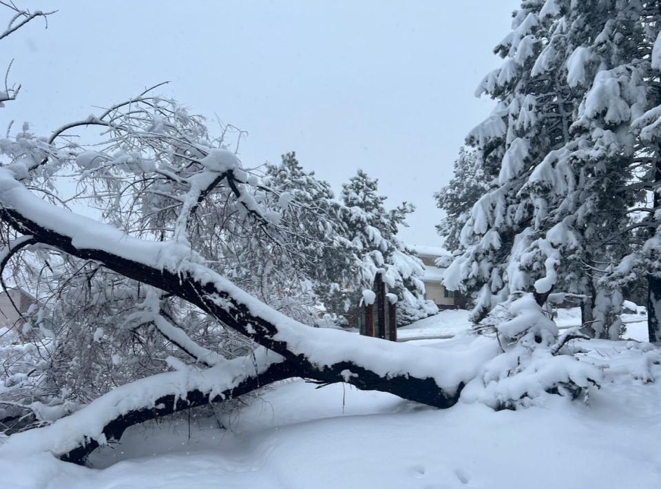
Storm uproots trees near Denver
As of 7 p.m., snow continues to fall around the Denver metro area, the accumulation of moisture uprooting trees.
— Natasha Lovato
Highway 14 to Ted's Place reopens
Colorado Highway 14 has reopened between mile marker 61 to 121 at Ted's Place after being closed for about two hours. Snow removal activities are ongoing in the area.
— Sady Swanson
Denver under winter storm warning
DENVER - Denver is in a winter storm warning until 6 a.m. Friday. Snow is still actively falling and roads are icy from last nights rain. According to the National Weather Service, there are 14 mph wind gusts and seven inches of snow have accumulated.
— Natasha Lovato
Highway 14 closed to Ted's Place
The Colorado Department of Transportation has closed Colorado Highway 14 from mile marker 61 to 121 at Ted's Place due to multiple slide offs, a jack-knifed semi-truck and general inclement weather conditions impacting the roadway. There is no estimated time of reopening.
CDOT crews are closing CO HWY 14 from MM 61 to MM 121 (Ted's Place) due to multiple slide offs, a jack-knifed semi, and generally inclement weather conditions affecting the roadway. No estimated time for reopening the roadway. More information to follow.
— LETA (@LETA_911) March 14, 2024
— Sady Swanson
Colorado ski area closed as storm hammers mountains
At least one Colorado ski area was closed Thursday as snow hammered the mountains and prompted road closures.
Eldora said it was closed all day Thursday "for the safety of our staff and guests."
On the conditions page of its website, Eldora announced Thursday that "we have experienced multiple snow slides on Shelf Road (our access road) since about 3:00 AM and remain concerned about further slide danger on the road today. We hope to resume normal operations tomorrow. In the meantime, stay home, stay safe, shovel out, and enjoy the beautiful weather!"
— Sarah Kyle
'Strong and wide band of snow' coming to Interstate 25 corridor
Thursday morning, it looked like Fort Collins might miss any significant snow. That could be changing, as a "strong and wide band of snow is moving into the I-25 corridor from the northeast," the National Weather Service said in an 11:35 a.m. post on X, formerly called Twitter.
The weather service said 5-10 inches of additional snow is expected in the Denver metro area, and more than a foot of additional snow is expected in the foothills.
We promised more snow and here it comes! A strong and wide band of snow is moving into the I-25 corridor from the northeast. This will increase snowfall rates through the evening. We expect 5-10" of additional snow in the Denver metro and over a foot in the foothills. #COwx pic.twitter.com/Pt6AFCVAD8
— NWS Boulder (@NWSBoulder) March 14, 2024
We'll keep you updated as things develop in the Fort Collins area.
— Sarah Kyle
Front Range Community College announces remote operations for Friday
Front Range Community College will conduct operations and services remotely Friday, March 15.
Thursday, all Front Range Community College campuses, including in Fort Collins, were closed for all services due to anticipated weather conditions.
Like Colorado State and Poudre School District, Front Range Community College is on spring break this week, so the closure does not impact classes.
— Sarah Kyle
Snow starts falling in Fort Collins
Coloradoan journalists across Fort Collins reported snow starting to fall, including "big, fluffy flakes." In an earlier snowfall forecast map, the National Weather Service said between 3-8 inches could hit the city by 6 a.m. Friday.
— Sarah Kyle
'Snowmaggeddon' has been a bust for northeast Larimer County so far. Here's where it's hitting harder.
While northeast Larimer County, including Fort Collins, has been largely passed over by the heavy snow seen in other areas of Colorado Thursday, Larimer County Sheriff's Office warned that areas to the south and the mountains are seeing more impacts.
"While the Northeast part of Larimer County is mostly seeing a light drizzle this morning, Snowmaggeddon is hitting the mountains & southern areas much harder," the sheriff's office said in a post on X. "If you need to travel today, reconsider your route & please delay if it takes you toward the purple."
Speaking of that purple, the sheriff's office shared the below post and map from the National Weather Service in Boulder in its post about Larimer County impacts:
It's still snowing hard in the Denver metro & foothills. However, you will notice a "back edge" to the snow approaching Denver from the northeast. This will result in a lull in snow during the late morning. More widespread & intense snow will redevelop later this afternoon! #COwx pic.twitter.com/80i7Kb74vs
— NWS Boulder (@NWSBoulder) March 14, 2024
— Sarah Kyle
I-70 remains closed west of Denver
Interstate 70 remains closed between Denver and Silverthorne, "a lot more snow coming today," the weather service said in a post on X.
I-70 still closed with a lot more snow coming today. Check https://t.co/uoUwxQXFoP for the latest closures. #cowx https://t.co/JH9M9hb6ws
— NWS Boulder (@NWSBoulder) March 14, 2024
"If you have to ask "How do I get there?", the answer is you can't," Colorado State Patrol of Golden said in a post on X that was shared by the weather service Thursday morning.
Here is a view of I-70 just west of Floyd Hill.
REMINDER: I-70 IS CLOSED from Denver to Silverthorne.
If you have to ask "How do I get there?", the answer is you can't. S1 pic.twitter.com/ZMODdNuRql— CSP Golden (@csp_golden) March 14, 2024
Find the latest road closures at cotrip.org.
— Sarah Kyle
Heavy snow misses Fort Collins so far, but here are a few early Colorado snow totals and what to expect Thursday
As some areas of Colorado got pummeled with snow overnight Wednesday, no snow had accumulated in the northeast side of Fort Collins as of early Thursday morning.
In a post on X, the social media platform formerly known as Twitter, just before 3:30 a.m., the National Weather Service in Boulder shared some of the heaviest snow totals so far:
Aspen Springs (foothills of Gilpin County): 23 inches
4 SE Pinecliffe (foothills of north Jefferson County): 18.5 inches
3 W Jamestown (foothills of Boulder County): 14.3 inches
Fort Collins remains under a winter weather advisory through 6 a.m. Friday, and the Front Range mountains and foothills are among areas under a winter storm area in effect through 6 a.m. Friday.
After a brief lull in the heavier snowfall this morning, it will increase again by this afternoon. Winter Storm Warnings continue for the North Central Mountains, Front Range Foothills, South Park, the Denver Boulder 🙴 Palmer Divide through 6 AM Friday. #COwx pic.twitter.com/VwLfjHEQrg
— NWS Boulder (@NWSBoulder) March 14, 2024
The weather service advised there would be a lull in snow Thursday morning, particularly on the I-25 corridor, but said it expects more snow Thursday afternoon and evening.
The weather service is still calling for some snow to hit Fort Collins Thursday into Friday morning. Its Thursday morning forecast called for a possible 1-2 inches during the day Thursday and a possible 2-4 inches more Thursday night.
A snowfall forecast map shared by the weather service just before 6:15 a.m. Thursday showed a range of 3-8 inches for Fort Collins through early Friday morning.
MORE SNOW!!! After a lull along portions of the I-25 Corridor this morning, snow is expected to become more widespread and heavier again this afternoon and evening. Another 6-12" coming for Denver metro, and 14-26" more for the foothills. Lighter amounts farther east. #COwx pic.twitter.com/bwl7Awu7Ds
— NWS Boulder (@NWSBoulder) March 14, 2024
The weather service is still advising against travel in and near the Front Range foothills through late Thursday night, noting in a post on X that it will be "difficult to nearly impossible" to do so.
Here's a visual explainer of areas the weather service says travel isn't advised:
The Winter Storm Severity Index map shows are large area of extreme impacts 🙴 TRAVEL IS NOT ADVISED especially Front Range mountains 🙴 foothills through Friday morning. #COwx pic.twitter.com/Sf6k23HJc2
— NWS Boulder (@NWSBoulder) March 14, 2024
— Sarah Kyle
Winter weather advisory issued for Larimer County
The National Weather Service issued a winter weather advisory for Larimer County below 6,000 feet and portions of Weld County Wednesday night.
The advisory said the heaviest snow is expected south of Fort Collins and Greeley, with 2 to 10 inches of snow accumulating from midnight through 6 a.m. Friday. It also warned of wind gusts up to 50 mph Thursday.
"Travel could be very difficult, especially on less traveled roads," the advisory stated. "Slow down and use caution while traveling."
A winter storm warning remains in effect for much of Colorado's higher elevations — including Rocky Mountain National Park and the Medicine Bow Range, the mountains of Summit County, the Mosquito Range, the Indian Peaks and the Front Range foothills — through 6 a.m. Friday.
Call 511 or visit cotrip.org for road condition updates.
— Sarah Kyle
Here are updated expected snow totals for different areas of Colorado, including Fort Collins
The National Weather Service shared these updated expected snowfall amounts for 6 p.m. Wednesday through 6 a.m. Friday in a Wednesday night post on X:
Boulder: 21.7 inches
Breckenridge: 6.7 inches
Castle Rock: 23.2 inches
Denver: 15.6 inches
Estes Park: 18.1 inches
Evergreen: 34.3 inches
Fort Collins: 5.2 inches
Ft. Morgan: 0.6 inches
Greeley: 1.8 inches
Julesburg: No accumulation expected.
Kremmling: 1.5 inches
Limon: 4.3 inches
Longmont: 11 inches
Sterling: 0.4 inches
Walden: 2.8 inches
— Sarah Kyle
Thompson School District schools, offices closed Thursday
Thompson School District schools and offices will be closed Thursday due to the storm, the district announced Wednesday evening.
The closure includes in-person, remote and Thompson online learning programs in addition to any activities, athletics and before- and after-school care, the district said.
Poudre School District and Colorado State University are on spring break this week.
— Sarah Kyle
Avalanche warning issued for Rocky Mountain National Park and Front Range mountains
The Colorado Avalanche Information Center has issued an avalanche warning for Rocky Mountain National Park, Medicine Bow Mountains, Never Summer Mountains, Indian/James peaks, Pikes Peak, Sawatch Range and the Sangre de Cristo Range from 5 p.m. Wednesday through 5 p.m. Friday.
Heavy snow and strong wind have created dangerous avalanche conditions and large and dangerous avalanches will be easily naturally triggered during the warning period.
Avoid backcountry travel in these areas.
For more information, visit https://avalanche.state.co.us/
— Miles Blumhardt
Rocky Mountain National Park to remain closed Thursday due to snowstorm
Rocky Mountain National Park closed its east side access at 5 p.m. Wednesday due to the significant snowstorm forecast and those roads remained closed Thursday.
The National Weather Service is calling for 18 to 24 inches of snow in Estes Park and 27 inches at Bear Lake in the park into Friday.
These closure includes Trail Ridge Road at Beaver Meadows and Fall River entrances, Bear Lake Road and the Wild Basin Road.
Trail Ridge Road on the west of the park remains open to the Colorado River Trailhead.
— Miles Blumhardt
Front Range Community College classes canceled Thursday due to snow forecast
All Front Range Community College campuses, including in Fort Collins, will be closed for all services March 14, due to anticipated weather conditions.
The college will move to remote operations March 15 and expects to resume regular operations March 16.
Updates will be posted on its website, social media accounts, @FRCCedu on X, Facebook and Instagram.
— Miles Blumhardt
Colorado officials warn of impending travel impacts. Here are key points:
The Colorado Department of Transportation, Colorado State Patrol and Colorado Avalanche Information Center held a Zoom meeting at 9:30 a.m. Wednesday addressing forecast travel and safety issues accompanying the storm.
Refrain from driving in impacted areas for 24 to 36 hours if possible Thursday into Friday.
If you can work from home Thursday, do so as major roads are expected to be impacted by as much as 1 to 2 feet of snow along with high wind creating whiteout conditions.
If you must travel, make sure your gas tank is full in case of you get stranded, cellphone is fully charged and you pack extra clothing, food and water.
Safety closures are expected for areas, including I-70 from Golden to the Eisenhower Tunnel and I-25 from Castle Rock to Colorado Springs.
Obey road closures. They are for the protection of snowplow drivers as well as the general public. Stranded motorists in road closures hamper snow clearing operations.
Safety closures are possible for avalanche mitigation in the Eisenhower Tunnel, Loveland and Berthoud pass areas.
I-70 is expected to be cleared in time for weekend ski traffic.
— Miles Blumhardt
Foothills, mountains under winter weather warning; Fort Collins area under winter weather watch
Warning: In effect noon Wednesday to 6 a.m. Friday for areas including the western three-quarters of Larimer County, Red Feather Lakes, Estes Park, Rocky Mountain National Park, Boulder, Denver, Denver International Airport and Castle Rock. Total snow accumulations of 18 to 36 inches with localized totals up to 4 feet and wind gusts to 40 mph along the eastern slopes of the Front Range.
Watch: In effect 9 p.m. Wednesday to 6 a.m. Friday for Fort Collins, Greeley and surrounding area with 4 to 10 inches of snow possible.
— Miles Blumhardt
Travel strongly discouraged in Colorado foothills and mountains starting Wednesday evening
Snowfall rates of up to 3 inches per hour in places and high winds from Wednesday evening through Thursday morning will make travel nearly impossible on foothills and mountain roads, according to the National Weather Service.
Major roads impacted include the Interstate 70 mountain corridor from Golden to Vail and Interstate 25 from Denver to south of Pueblo.
Safety closures for snow removal, avalanche or due to adverse conditions are possible.
Avoid travel during this powerful winter storm. If you must travel in an emergency, keep an extra flashlight, food and water in your vehicle.
For the latest road conditions for Colorado, call 511 or visit www.cotrip.org.
— Miles Blumhardt
Heavy snow in/near the Front Range Mountains, Foothills 🙴 Palmer Divide. Storm totals will range from 1-3 feet in the mountains/foothills (locally up to 4 feet) 🙴 Palmer Divide, with 8-20 inches over the Greater Denver-Boulder area. #COwx pic.twitter.com/rgGIbxMRbr
— NWS Boulder (@NWSBoulder) March 13, 2024
Colorado storm travel impacts: Definitely check ahead if you are flying out of DIA
There is a strong potential the storm will impact Thursday flights at DIA with 5 to 16 inches of snow forecast for the airport.
Check with your airline before heading to the airport.
— Miles Blumhardt
Heavy snowfall for areas in/near the Front Range Mountains, Foothills 🙴 Palmer Divide including the greater Denver/ Boulder area. Deteriorating conditions will dvlp this afternoon/tonight 🙴 continue into Thursday night. Conditions will slowly improve Friday. #COwx pic.twitter.com/EW94s60CP0
— NWS Boulder (@NWSBoulder) March 13, 2024
Why the uncertainty for Fort Collins' snowfall total?
The Cheyenne Ridge is a rise in topography stretching from Cheyenne to near Sterling and as far south as just north of Fort Collins that influences precipitation in our area.
Upslope conditions, as with this storm, are known to produce heavy precipitation, be it snow or rain. This condition takes place when moisture wraps around from the east and slams into the mountains, which wring out the moisture along the east slope of the mountains and onto the I-25 corridor.
National Weather Service meteorologist Jim Kalina said there is uncertainty of the impact of downsloping wind, which produces drier conditions, off the Cheyenne Ridge that could limit the upslope condition and precipitation.
— Miles Blumhardt
Forecast snow totals for the Fort Collins area, Denver area and Colorado mountains/ski resorts
Here are snowfall ranges from the National Weather Service as of Wednesday morning:
Fort Collins and surrounding area:
Fort Collins: 1 to 14 inches forecast (5 inches expected).
Loveland: 2 to 16 inches forecast (6 inches expected).
Wellington: 1 to 11 inches forecast (4 inches expected).
Red Feather Lakes: 16 to 39 inches forecast (24 inches expected).
Windsor: 0 to 10 inches forecast (2 inches expected).
Greeley: 0 to 7 inches forecast (1inch expected).
Estes Park: 8 to 27 inches forecast (17 inches expected).
Berthoud: 3 to 17 inches forecast (7 inches expected).
Cameron Pass: 13 to 33 inches forecast (20 inches expected).
Buckhorn Mountain: 19 to 46 inches forecast (32 inches expected).
Bear Lake (RMNP): 17 to 40 inches forecast (27 inches expected).
Denver and surrounding area:
Denver: 5 to 17 inches forecast (11 inches expected).
Denver International Airport: 5 to 16 inches forecast (9 inches expected).
Boulder: 6 to 22 inches forecast (15 inches expected).
Longmont: 3 to 17 inches forecast (8 inches expected).
Mountains/ski areas:
Eisenhower Tunnel: 13 to 28 inches forecast (19 inches expected).
Loveland Pass: 15 to 33 inches forecast (24 inches expected).
Berthoud Pass: 17 to 39 inches forecast (23 inches expected)
Vail Pass: 7 to 17 inches forecast (11 inches expected).
Winter Park: 14 to 29 inches forecast (22 inches expected).
Copper Mountain: 6 to 20 inches forecast (11 inches expected).
Keystone: 8 to 21 inches (13 inches expected).
Breckenridge: 9 to 24 inches (12 inches expected).
— Miles Blumhardt
This article originally appeared on Fort Collins Coloradoan: Colorado's mid-March snow storm is 'in our rearview mirror'

