Several Florida counties under tornado watch as storms continue to move across state
Tornado watch canceled for Flagler, Marion, Putnam counties
12:11 p.m.: The tornado watch for Flagler, Marion and Putnam counties has been canceled.
Tornado warning issued for 3 counties

10:58 a.m.: A tornado warning was issued for Hernando, Pasco, and Sumter counties till 11:30 a.m. Strong rotation capable of producing a tornado was spotted near the Hernando County Airport and Brooksville. Storms are moving toward Spring Lake and Hill 'N Dale. Residents are advised to seek shelter immediately.
Threat for severe weather over for Tallahassee area
9:45 a.m.: The National Weather Service, Tallahassee, said the threat for severe weather is over for the area.A few showers in the eastern Big Bend continue.
Temperatures have fallen into the mid-50s to near 60, with some areas near 70 ahead of the cold front.
Strong storms moving ashore along central Florida's Gulf Coast
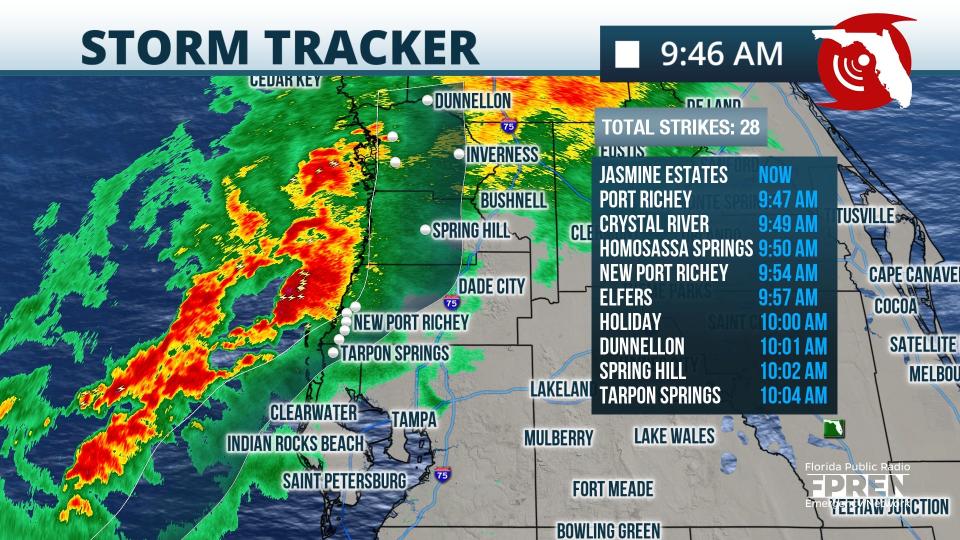
9:50 a.m.: Strong storms are beginning to move onshore. Storms could bring damaging winds and tornadoes, according to the Florida Public Radio Emergency Network. A tornado watch is in effect until 4 p.m.
NWS records reports of 6 tornadoes
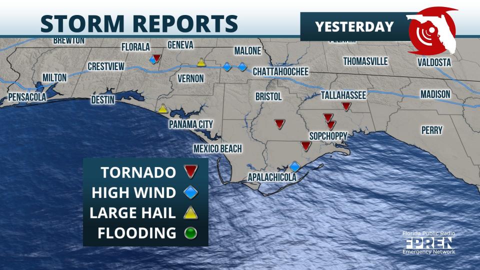
9:30 a.m.: The National Weather Service has recorded six tornado reports from Wednesday night.
Tornadoes were reported from Walton County into Leon County and south of Tallahassee. Surveys over the next several days will determine the exact number of tornadoes and the extent of the damage, according to the Florida Public Radio Emergency Network.
Reported tornadoes ripped down trees and damaged at least one home in North Florida on Wednesday night and heavily damaged a cotton mill in South Georgia early Thursday.
Storm system spawns tornadoesSuspected tornadoes cause damage in North Florida, South Georgia
Tornado watches issued for West Coast, Central Florida
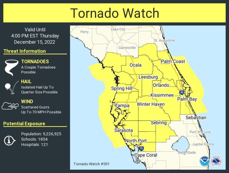
8 a.m.: A tornado watch has been issued for several more Florida counties until 4 p.m.
A complete list of the counties under a tornado watch include: Brevard, Charlotte, Citrus, DeSoto, Flagler, Hardee, Hernando, Highlands, Hillsborough, Lake, Levy, Manatee, Marion, Orange, Osceola, Pasco, Pinellas, Polk, Putnam, Sarasota, Seminole, Sumter and Volusia.
Tornado watch issued for east central Florida counties

7:58 a.m.: The National Weather Service has issued a tornado watch for six counties until 4 p.m.The watch is in effect for: Brevard, Lake, Orange, Osceola, Seminole and Volusia counties.
Tornado watch issued for Big Bend area
6 a.m.: A tornado watch is in effect for some areas this morning as a line of storms moves through the state ahead of a cold front.
The tornado watch is in effect until 9 a.m. for five counties in the Big Bend area, including: Dixie, Jefferson, LaFayette, Madison and Taylor, according to the National Weather Service.
Track storms as they move across Florida
Stormy weather is likely all morning across North Florida and from the Big Bend coast down to the Tampa area, according to the Florida Public Radio Emergency Broadcast Network. Storms are most likely this afternoon I-4 south through the central part of the state. Damaging winds and isolated tornadoes are possible.
Isolated tornados will be possible with storms moving in from the west for Marion, Putnam and Flagler counties until 2 p.m., according to the National Weather Service, Jacksonville. Wind gusts of 40 to 5 mph will be possible with the storms.
Showers and thunderstorms are forecast to move southeast through the Nature Coast this morning, the Tampa Bay area during the late morning and early afternoon, and Southwest Florida this afternoon and evening, according to the National Weather Service, Tampa Bay.
Cold front on its wayCold front moving toward Florida behind line of storms that could bring severe weather
Powerful storms3 killed, others trapped in tornado-battered homes in Louisiana, blizzard in North; ice headed to Northeast
Some strong or severe thunderstorms are possible, with damaging winds gusts, isolated tornados and water spouts, small hail, isolated flooding, and frequent lightning possible along the west coast.
While the line itself will move toward the southeast, any storms will move quickly toward the east to northeast up to 35 to 40 mph and offshore, according to the National Weather Service, Melbourne.
The storms are expected to reach Lake and Volusia counties by late morning, and continue southeast through east central Florida through the afternoon, with showers and storms gradually weakening as they near Okeechobee County and the Treasure Coast by late afternoon into early evening.
Primary storm threats will be frequent lightning strikes and strong to locally damaging wind gusts of 40 to 60 mph. However, an isolated tornado or two will also be possible. Small hail and locally heavy rainfall of 1 to 2 inches may occur with any storm.
Florida radar shows line of storms

Stay informed by following @FloridaStorms on Twitter
This article originally appeared on Sarasota Herald-Tribune: Florida weather: Tornado watches in effect for some areas

