Live updates: Severe thunderstorm watch back in effect
At least one confirmed tornado was confirmed to have touched down in the Florida Panhandle on Thursday night, resulting in the death of one person in Pensacola.
One of the tornadoes, which was confirmed to have touched down in West Pensacola killed one person who was found trapped under a tree that had fallen on their home.
Jump to:
Severe thunderstorm watch back in effect
A severe thunderstorm watch is in effect until midnight in Escambia and Santa Rosa counties, according to the National Weather Service in Mobile, Alabama.
Additionally, Northwest Florida, portions of Alabama and southeastern Mississippi are under flood watch until 7 p.m. Saturday.
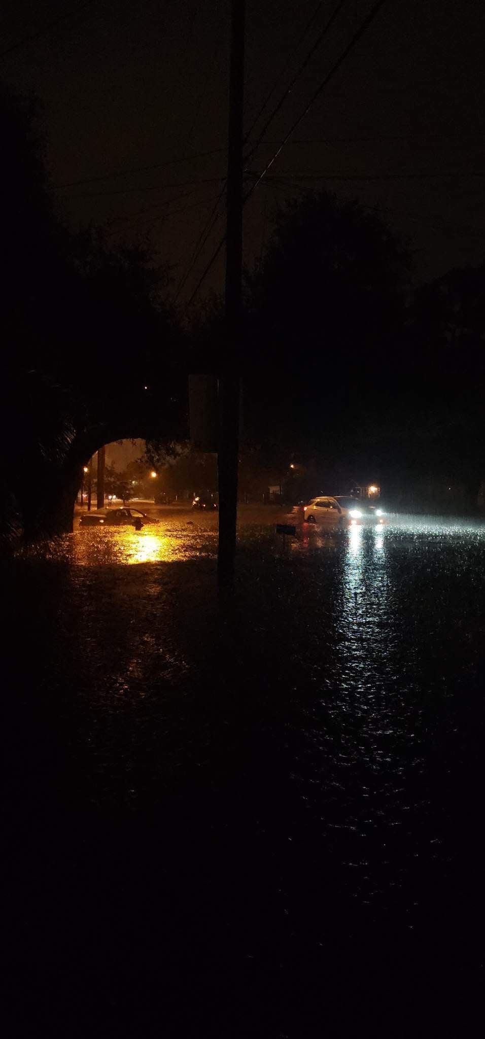
Many areas of Pensacola received more than a foot of rainfall between Thursday night and Friday morning, saturating the ground and filling up many local stormwater retention ponds.
A second rounds of storms is expected to kick-off this evening and continue into Saturday.
Heavy rainfall is also forecast for Sunday, and the sustained rainfall may cause stormwater to accumulate in low-lying and flood-prone areas.
Motorists are urged to stay of the road tonight and stay tuned to local media for weather updates throughout the weekend.
Stay off the roads tonight; damaging winds above 60 mph projected
City officials are urging residents to stay off the roads tonight in advance of potentially severe weather.
There is an enhanced risk of damaging winds, tornadoes, large hail, high surf and dangerous rip currents starting at 4 p.m. tonight. The National Weather Service in Mobile projects that large swaths of damaging winds in excess of 60 mph, hail up to two inches in diameter and strong tornadoes are possible for Escambia County throughout the night.
Gallery Night, Palafox Market canceled due to potential for continued storms
Gallery Night has been canceled this evening due to continued severe weather alerts that threaten the area overnight tonight. The Escambia County Emergency Operations Center is activated at a Level 2, which means that staff that would otherwise be staffing the event will be unavailable.
The Escambia County Sheriff's Office also canceled its Sheriff's Movie Night. The movie, Luca, will be rescheduled.
Late on Friday afternoon, organizers also announced that Saturday morning's Palafox Market was canceled.
Lightning strike damaged ECUA wastewater pumping station
The Emerald Coast Utilities Authority reports a lightning strike has damaged one of its largest wastewater pumping stations. The Pipeline Station, located at the corner of Pipeline Road and Rainbow Avenue, is capable of pumping 50 million gallons of wastewater per day.
The strike damaged a 600 horsepower motor on one of the three pumps at the station and occurred at the height of the storm when flows within the system were extremely high.
The heavy flow and damaged motor created a situation that caused two 300,000-gallon excess flow tanks at the Pipeline Station to fill to capacity and begin discharging from overflow ports at the top of the tanks. In response, ECUA crews redirected the heavy flows to additional excess flow storage tanks. This provided enough relief at the station to abate overflows from the original tanks.
The estimated gallons of spillage was 525,030, a detail that was omitted from an ECUA news release on the incident but reported to the Florida Department of Environmental Protection and included in the DEP's public notice of pollution.
The overflows began at approximately 4:30 a.m., according to ECUA officials, and continued until shortly after 8 a.m.
Repairs at The Pipeline Station are expected to be completed today.
Pensacola Mayor D.C. Reeves reports live on Weather Channel
Pensacola Mayor D.C. Reeves updated a national audience through the Weather Channel Friday morning on the aftermath of the storm specific to the city.
Reeves said there had been "several" structure fires overnight believed to have been caused by the massive amount of lightning strikes hitting the area. City crews worked through the night assessing powerlines structures and streets.
He reported no human casualties within the city limits, though one person had to be rescued from their home.
Social media reaction: 'Wild storm, lots of flooding' in Pensacola. Weird weather tweets, TikToks and Instagrams
He said Pensacola Police were monitoring "three to four" roads still closed due to flooding.
Flood waters remained an issue Friday morning, Reeves said. Storm water retention ponds are nearing or at capacity. Emergency managers were monitoring radar. Initial concerns were that more rain would be pounding the city early in the day, but Reeves said that hadn't happened as yet.
"Any additional storms precipitation, winds or otherwise, we're concerned about trees coming down," he said.
He said non-essential employees who hadn't arrived at city hall by the time he went on air had been told to stay where they were.
"If you're in a safe place stay there," he said. "I would really impress upon our residents and visitors don't try to get someplace right now not try to be on the streets if you don't have to be."
6,300 households without power, damage assessment continues
The city of Pensacola is working on damage assessment and recovery efforts after severe weather impacted the area overnight and into Friday morning. Residents are encouraged to continue monitoring the forecast, as additional severe weather is possible today through the weekend.
Storms have continued across the area this morning, with additional severe storms possible starting at 4 p.m. through tonight. These severe storms are capable of producing damaging winds of 60+ mph, golf ball size hail or larger, and tornadoes.
City of Pensacola Information:
Road closures: Langley Avenue at Davis Highway, and 16th Avenue at Texar Drive are currently closed. There may be additional road closures as crews assess damage and rainfall continues.
Recorded rainfall: 11.56 inches at City Hall, 10.02 inches at Pensacola High School, 9.23 inches at Pensacola International Airport over 9 hours
Pensacola Fire Department responded to multiple calls overnight, including two residential structure fires, three power lines down, five mutual aid structure fires and one mutual aid rescue.
No storm-related injuries have been reported in the city.
City of Pensacola Inspections crews began assessing damage this morning, with no reports of structural damage in the city so far. Crews will continue their assessments for the remainder of the day.
Public Works and Parks and Recreation crews are working to clear any debris from city roadways, along with clearing storm inlets.
As of about 10 a.m., an estimated 5,300 Florida Power and Light customers were without electricity, according to FPL's online Power Tracker map.
Just over 1,000 people in Santa Rosa County and just under 3,500 people in Okaloosa County are without power, according to the website.
Escambia County residents who experience damage to their property or notice extreme damage to their street due to the recent storm are asked to notify Emergency Management using the Citizen Damage Report website. Once the report has been received, Emergency Management will determine if a team is needed to assess the damages.
The city of Pensacola provided the following safety information:
Residents are asked to please stay off the roadways if possible.
Please do not attempt to clear debris from city roadways, as street sweepers and crews will be out clearing debris as conditions are safe to do so.
Do not touch downed power lines. Call Florida Power and Light at 1-800-4-OUTAGE (1-800-468-8243) immediately to report a dangerous condition such as a downed power line.
Pay extra attention to local weather reports. Be sure to keep your weather radio on and your cell phone charged to ensure you can receive weather alerts.
With the possibility of high winds, it is recommended that any lightweight outside furniture or equipment be secured.
Organizations with planned outside activities during this period need to be weather aware and take the appropriate actions.
In the event of a Tornado Warning, move to an interior room on the lowest floor of your home or building. Stay away from windows.
Turn around, don't drown: In the event of a roadway covered by water, do not attempt to drive over the flooded road. Water depth may be misleading, and you could end up stranded or trapped.
With more rain ahead, sand available for sandbag in Escambia
Escambia County is offering sand for residents living in flood-prone areas. The sand is available on a first come, first served basis. Residents must bring their own sandbags and shovels to one of the following locations:
Baars Field Athletic Park - 13001 Sorrento Road, Pensacola
Brent Athletic Park - 4711 N. W St., Pensacola
Don Sutton Park - 2320 Crabtree Church Road, Molino
Equestrian Center - 7750 Mobile Highway, Pensacola
Escambia County Road Department - 601 Highway 297-A, Pensacola
Ferry Pass Middle School - 8355 Yancey Lane, Pensacola, (sand will be on the northwest corner of school property on Parazine Street)
John R. Jones Jr. Athletic Park - 555 E. Nine Mile Road, Pensacola
Travis M. Nelson Park - 4541 County Road 4, Pensacola
When laid properly, sand bags can be an effective tool for flooding from a rain event, but not for storm surge. For more information on how to make and use sandbags, visit the Federal Alliance for Safe Homes at flash.org.
Sand bags can be purchased at most local hardware or home improvement stores, typically for a low cost.
140 Forest Creek Apartments residents evacuated, 'severe damage' in West Pensacola
Davis Wood, public safety information officer for Escambia County, said there are "severe damages" in the West Pensacola area, and that more than 140 people had been evacuated from the Forest Creek Apartment at 34 Patton Drive. The apartment complex is prone to flooding, and there have been multiple instances in the past decade of people losing their cars, furniture and other belongings to flood waters.
Wood said through a collaborative effort of Escambia County Area Transit, Escambia County Fire Rescue and the Sheriff's Office, Forest Creek residents are being transported to the Marie K. Young Community Center as a temporary shelter.
Forest Creek Apartments evacuated: Over 140 Forest Creek Apartment residents were evacuated after severe storms hit the area
Crews are assessing damage and clearing debris from roadways throughout the county.
Around 8 a.m., Wood said, "I can confirm, based on last word from our roads department head, that we do not have any roadways that are closed down right now. As we have another storm coming through, we are going to remain activated at a Level 2, just so we can monitor the storm and monitor any other potential damages that could occur."
Escambia County Area Transit will suspend all service Friday. This includes fixed route, UWF Trolleys, and the Pensacola Beach Island Trolley. Riders may call 850-595-3228 or visit goECAT.com for additional information.
Five Santa Rosa homes struck by lightning
Fives homes in Santa Rosa County were struck by lightning Thursday night, according to Santa Rosa County officials. The lightning strikes were spread out among Gulf Breeze, Pace and Navarre. Several roads were closed in the early morning hours due to flooding, but have reopened with hazards and drivers are asked to be cautious.
Lightning struck homes in the following areas:
700 block of Peakes Point Drive in Gulf Breeze
300 block of Deer Point in Gulf Breeze
1300 block of Soundview Trail in Gulf Breeze
5000 Covington in Pace
3000 block of Turquoise Drive in Navarre
Pensacola sees 13th highest all-time daily rainfall total in just 6 hours
The Pensacola airport received 9.3 inches of rain yesterday, from midnight to midnight, most of which occurred during a six-hour time period. The highest hourly rain rate was 3.45 inches.
The torrential rainfall in Pensacola Thursday night ranked as the 13th- all-time daily total and the third highest for June in recorded history, according to William Schmitz of the Southeast Regional Climate Center.
The highest single-day total occurred during historic rainfall that happened in April 2014 that caused significant flooding throughout Escambia and Santa Rosa counties.
Pensacola radar, watches and warnings: Severe weather? Watch radar, stay informed of watches, warnings issued for Pensacola
The National Weather Service's official account of the April 2014 flood estimates that more than 20 inches of rain fell at the Pensacola International Airport in 48 hours from April 28 to April 30. But that's only an estimate as a power outage during the storm forced the weather service to rely on radar readings to estimate the rainfall.
Two years after the floods, Escambia County estimated that 22 inches of rain fell within 29 hours, putting the event between a 100-year and 200-year flood.
A 100-year rain event for much of the Pensacola area is defined as 16 inches of rain in a 24-hour period, according to the National Oceanic and Atmospheric Administration, meaning there's a 1% chance each year that 16 inches will occur in a 24-hour period.
One person killed in Pensacola tornado
Escambia County Fire Rescue and Emergency Medical services responded to a call at the 500 block of Coker Lane at 8:38 p.m. where the person was pronounced dead at the scene, according to Escambia County spokesperson Andie Gibson.
Another tornado was confirmed in Gulf Breeze, where it moved west and crossed Santa Rosa Island at the western end of Pensacola Beach. No damage has been reported yet, according to the city.
Pensacola gets 12-16 inches of rain: Pensacola under flash flood warning; 12-16 inches of rain fell with more coming
A house fire was also reported in the 20 block of East Galvez Court on Pensacola Beach and was brought under control by 9:40 p.m. It was unclear if the fire was related to the storms passing over the area.
Severe flash flooding continued to be a looming threat as 12-16 inches of rain fell overnight and additional showers developed within the region. A flood watch is in effect until 7 p.m. in Escambia and Santa Rosa Counties while a flash flood warning was extended until 10:15 a.m. Friday morning.
Local emergency management reported that the Pensacola area experienced significant flooding in West Pensacola, Warrington and Gulf Breeze.
Pensacola residents posted images and videos of flooded roadways, parking lots, downed trees and more.
Pensacola tornado confirmed: Tornado confirmed in Escambia County, one person killed
What roads are closed in Pensacola
Langley Avenue at Davis Highway, and 16th Avenue at Texar Drive are currently closed. There may be additional road closures as crews assess damage and rainfall continues.
What roads are closed in Gulf Breeze
Highway 98, also known as Gulf Breeze Parkway, has partially reopened between Daniel and Fairpoint drives. Motorists are asked to use caution in the area due to water on the roadway.
What to do if you encounter a flooded roadway
Motorists should avoid driving through flooded roadways as it’s impossible to tell whether or not the pavement has been washed out, if there is hidden debris or downed power lines.
If you see a flooded roadway, turn around and report it by using Pensacola 311 by dialing 311 on your phone, clicking this link or downloading the Pensacola 311 mobile app (iOS | Android).
Weather watches and warnings issued for Pensacola
If you can't see any local weather warnings here, you'll need to open this story in a web browser.
Pensacola weather radar

This article originally appeared on Pensacola News Journal: Pensacola weather: Tornado confirmed, 1 dead in Florida storms

