LIVE UPDATES: Hurricane Ian now a Category 2 as it moves inland over Florida
Get Hurricane Ian updates texted to you from the Bradenton Herald. Sign up at joinsubtext.com/hurricaneupdates
Hurricane Ian has weakened to a Category 2 hurricane hours after its landfall in Southwest Florida on Wednesday afternoon.
The storm is expected to move over central Florida Wednesday night and Thursday morning and emerge over the western Atlantic by late Thursday as a tropical storm with maximum sustained winds around 65 mph.
Threats from the storm overnight include continued storm surge, tropical storm to hurricane force winds and heavy rains that are likely to trigger flash flooding throughout Southwest and Central Florida.
Here’s the latest:
Rain and flooding threat persists for for Southwest Florida, Tampa Bay
The National Weather Service of Tampa Bay advises that rainfall amounts of 8 to 12 inches and growing in Southwest Florida and Tampa Bay are likely to cause major flooding to the coastal area, even as Hurricane Ian moves further inland.
As #Ian continues to push inland across central FL, widespread extremely heavy rainfall will continue to fall in the northwest eyewall of the system. This map shows us a swath of 8-12" has fallen in the past 6 hours with major flooding likely in the affected areas. #FLwx pic.twitter.com/As7TXLdCoO
— NWS Tampa Bay (@NWSTampaBay) September 29, 2022
A flash flood warning for Manatee County has been extended until 1 a.m. Thursday.
NWS warns of “life-threatening flash flooding of creeks and streams, urban areas, highways, streets and underpasses.”
Eastern areas of Manatee County, including Myakka City, are at particular risk for flooding.
— 10:15 p.m.
Over 164,000 homes without power in Manatee
As of 9 p.m., over two-thirds of homes serviced by Manatee County’s two major electricity providers, Florida Power & Light and the Peace River Electric Cooperative, were out of power.
FPL, which reports that nearly 130,000 of its more than 198,000 customers are without power, says restoration estimates are not available at this time.
“Please know we will continue to restore outages, including in-between the storm’s weather bands, as long as it is safe to do so,” FPL’s website says.
Outages can be checked and reported online.
To check FPL’s outage map, visit www.FPLMaps.com;
To check Peace River’s outage map, visit https://members.preco.coop/maps/OutageWebMap/.
— 9 p.m.
Hurricane Center forecast update
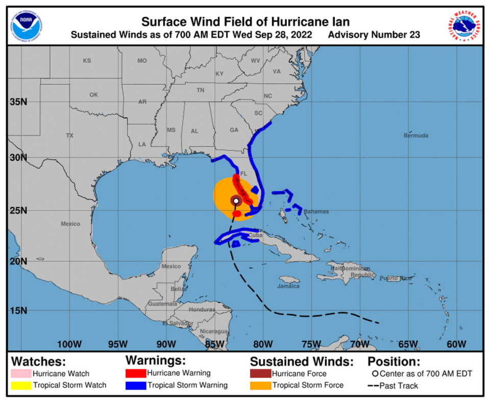
At 8 p.m., Hurricane Ian had weakened to a Category 3 with 115 mph winds, and the storm was moving northeast with the eye to the east of Arcadia.
Hurricane-force winds extend up to 50 miles from the center and tropical storm-force winds by 175 miles.
“Further weakening is expected for the next day or so, but Ian could be near hurricane strength when it moves over the Florida East coast tomorrow, and when it approaches the northeastern Florida, Georgia and South Carolina coasts on Friday,” the National Hurricane Center said.
— 8 p.m.
Ian makes landfall
Hurricane Ian made landfall in Cayo Costa at 3:10 p.m., and the center of the storm could move over east Manatee County this evening.
The Hurricane Center said sustained winds had dropped slightly to 150 mph, moving north-northeast at 9 mph.
Bay News 9 Chief Meteorologist Mike Clay reported a 72 mile per hour gust in Bradenton.
The National Hurricane Center’s online map shows the center of storm is forecast to move over the southeast corner Manatee County near Myakka City around 8 p.m. before moving slowly towards Hardee and Polk counties.
The storm is also expected to stay intact and cross over to the east coast as a hurricane.
It’s also forecast to slow down to a crawl and soak the state with heavy rain and storm surge.
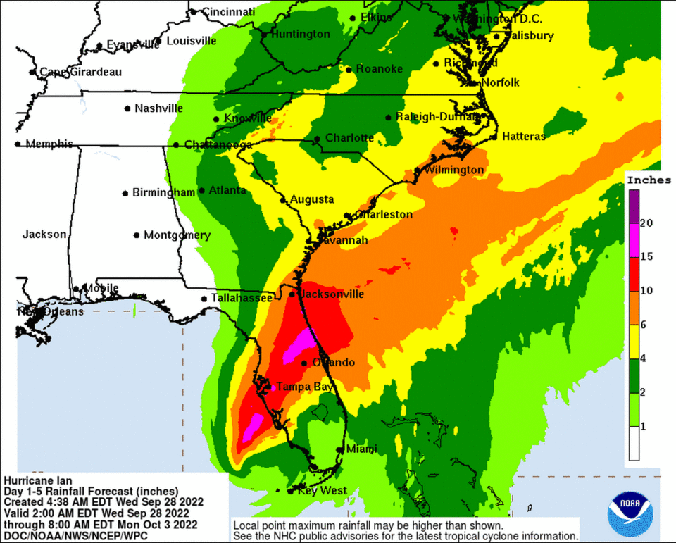
By Friday morning, Manatee County could see a total of 12 to 13 inches of rain, with some isolated areas possibly seeing up to 20 inches of rain, the weather service said.
A hurricane warning, tornado watch and flood watch remain in effect through at least Thursday night.
Forecasters expect Ian’s stormy conditions over Manatee County will start to dissipate Thursday night and Friday.
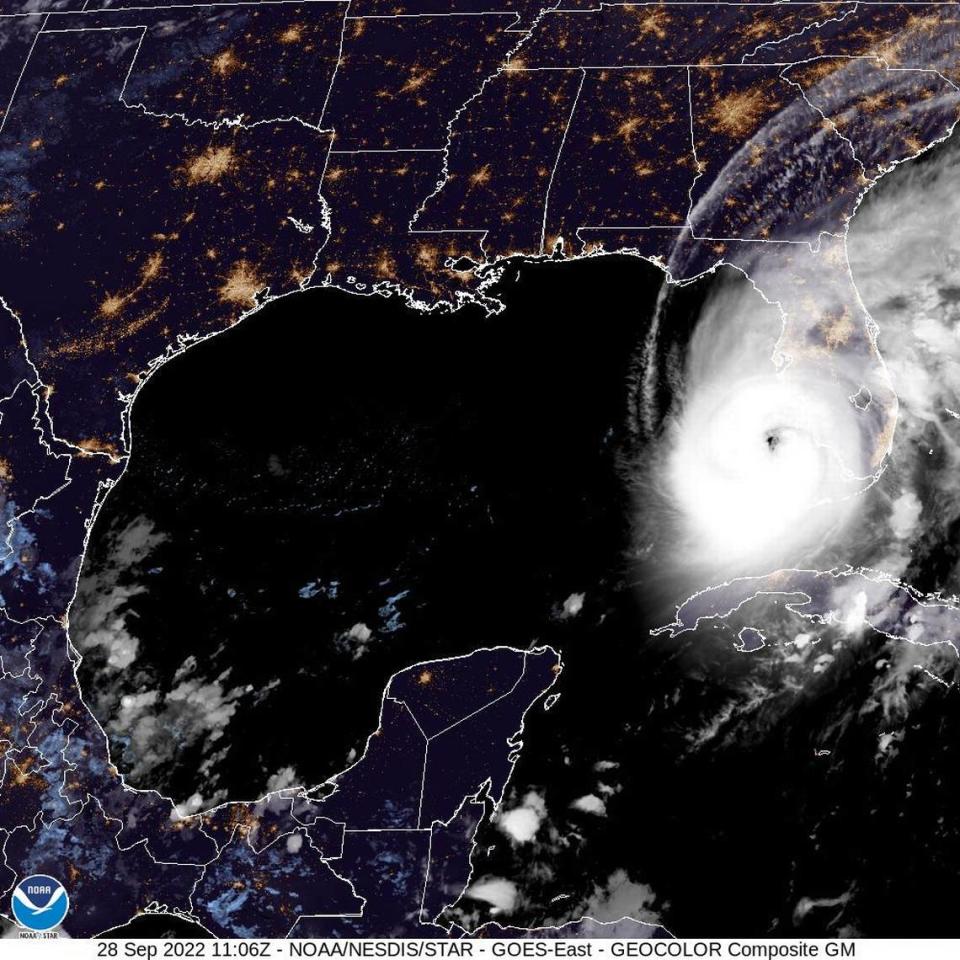
305 PM EDT 28 Sep -- Hurricane #Ian has made landfall as an extremely dangerous Category 4 hurricane near Cayo Costa, Florida with maximum sustained winds at 150 mph. The minimum pressure from Air Force Reconnaissance Hurricane Hunters was 940 mb.
Latest: https://t.co/tnOTyfORCw pic.twitter.com/O3agPDOZHk— National Hurricane Center (@NHC_Atlantic) September 28, 2022
Flash flooding imminent for Bradenton, Manatee County
A flash flood warning is in effect for eastern Manatee County and Sarasota County through at least 9 p.m., the National Weather Service said Wednesday evening.
A flash flood warning means that flash flooding is imminent or occurring.
Impacted areas include Sarasota, Bradenton, Lakewood Ranch, Myakka City, Myakka River State Park, Lake Sarasota and Sarasota Springs.
Between 5 and 16 inches of rain have fallen in the flash flood warning area, which in addition to eastern Manatee and Sarasota includes Hardee, DeSoto, Charlotte, northern Lee, and southwestern Highlands counties. Additional rainfall amounts of 3 to 6 inches are possible in those areas through 9 p.m., NWS said.
— 7 p.m.
Hurricane Center forecast update
Hurricane Ian continues its path inland after making landfall on Wednesday afternoon.
As of 5 p.m., Ian had weakened slightly but was still a Category 4 hurricane with sustained winds of 140 miles per hour. It was located about 5 miles east of Punta Gorda and 120 miles south-southwest of Orlando.
Ian is expected to continue weakening as it moves over Central Florida, becoming a Category 2 by the time it’s eye reaches the Lakeland area early Thursday. It will downgrade to a tropical storm by the time it reaches the the Volusia/Seminole County area on Thursday afternoon before it reemerges in the Atlantic.
Despite dropping wind speeds, the storm’s threats remain severe.
“As it moves inland, you’ll see the eye start to diminish. But don’t let that fool you,” NHC acting director Jamie Rhome said in a Wednesday afternoon update. “It will still pack a formidable punch as it moves across the state of Florida along the I-4 corridor over the next couple of days.”
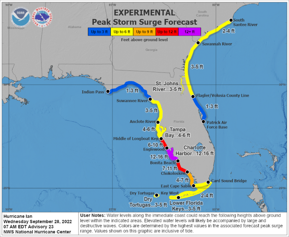
Storm surge impacts continue on the west coast of Florida as the storm moves fully on land, with Southwest Florida, from Englewood to Bonita Beach, seeing the highest levels at 12 to 18 feet.
Dangers from high wind, heavy rain, flash flooding remain, with watches and warnings still in place for Hillsborough, Pinellas, Manatee and Sarasota counties.
— 5 p.m.
When will Bradenton see the worst of Hurricane Ian?
After Hurricane Ian makes landfall as a Category 4 storm near North Port, the Bradenton area is expected to see hurricane- and tropical-storm-force winds until Thursday at 11 a.m.
The strongest winds will come around 4 p.m., according to the latest forecast, which predicts sustained wind speeds of 45 mph and gusts of up to 80 mph. Over the next 48 hours, Bradenton will see more than 11 inches of rain.
A storm surge warning remains in place for coastal areas in Manatee and Sarasota counties. While that warning remains in place, high-risk flood zone areas could see anywhere between 4 to 10 feet of storm surge, the NHC said.
— 1:30 p.m.
Heavy rain could cause Bradenton sewage spill
The city of Bradenton issued a warning to residents late Wednesday morning that further use of the wastewater system could lead to an overflow of raw or partially treated sewage into the Manatee River.
Earlier this year, a group of environmental conservation organizations hit Bradenton leaders with a lawsuit alleging that the city had repeatedly violated the federal Clean Water Act. Since 2017, the city’s wastewater plant has spilled more than 30 million gallons of sewage into the Manatee River.
In the meantime, residents who are sheltered at home within Bradenton city limits are asked to conserve their use of water by:
Limiting dishwashing
Limiting shower
Limiting toilet flushing
Limiting laundry
Public records show the city of Bradenton reported a wastewater overflow spill earlier this month. On Sept. 12, the city’s Public Works Department told the Florida Department of Environmental Protection that 9 million gallons of partially treated sewage spilled into the river.
City leaders settled the lawsuit, which requires an investment of $8 million toward improving the wastewater system, earlier this year.
— 1 p.m.
Weather deteriorates in Bradenton
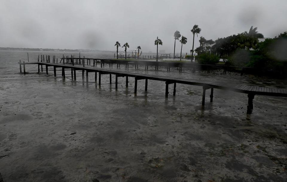
Manatee County began to feel the impacts of the outer bands of Hurricane Ian with heavy rain overnight, winds getting stronger and some power outages Wednesday morning.
A tornado watch has been issued for the area, in addition to the hurricane warning and flood watch.
“In Bradenton, this evening will be the worst,” National Weather Service Tampa Bay forecaster Ernie Jillson said of the center of Ian’s approach near Manatee County. “The center is forecast to cross the coast late this afternoon, early this evening. But the impacts are already picking up.”
But with the hurricane’s recent strengthening and it still being over the warm waters of the Gulf of Mexico, further intensification or shifts in the track could still occur despite a southern trend to the track over the last 24 hours.
“Just a little 15- or 20-mile wobble will bring it right to us,” Jillson said. “Those are impossible to forecast.”
Manatee County locks down shelters, emergency operations center
Shortly after 10 a.m. Wednesday, Manatee County officials began locking down evacuation shelters and the Emergency Operations Center. Residents who are still in line at the shelter will be allowed to enter.
The shelter closures came moments after an announcement from County Administrator Scott Hopes, who urged residents to make their way to a shelter as soon as possible.
Manatee’s shelters and the Emergency Operations Center, which is where emergency management leaders are monitoring the storm, will remain locked down until officials say it is safe to re-open the doors and allow residents to leave.
“The winds have reached the point where it’s not safe for fire, EMS or law enforcement to be out on the road. They have extended their maximum amount of time and now they have to go to safe places, as well,” Hopes said.
As of Wednesday morning, nearly 5,000 residents have taken advantage of the county’s shelters. That’s about twice as high as earlier this morning, following a “tremendous surge” of residents seeking shelter, Hopes said.
“Literally within an hour-and-a-half, the sheltered individuals doubled,” said Hopes. “Hopefully that’s a reflection of people also going to other homes to ride out the next 24-36 hours.”
— 11 a.m.
Last call for Manatee County shelters
In a Wednesday press briefing at 8:45 a.m., Hopes warned residents that evacuation shelters are about to begin locking the doors, which would prevent residents from entering or leaving the building until county officials say it is safe to do so.
“Now is the time for you to shelter in place. If you are already loaded up, and you are ready to put the dog, the cat, the iguana, the children, in your vehicle, you need to do it now because in about 30 minutes, we’re going to be locking down and the roads will be cleared because it will no longer be safe to be out and about,” Hopes said.
As of Wednesday morning, county officials said nearly 4,000 residents have taken advantage of the emergency shelters. While more than 100,000 homes were ordered to evacuate, Hopes said many of those people fled the county until it is safe to return.
“Many, many people did heed our advice. Now you see why I and the entire team were so adamant about evacuating and making sure you were in a safe place by last night,” Hopes said, pointing to some of the destruction Ian has already caused in the Bradenton area, such as downed trees and power outages ahead of the storm’s expected landfall this afternoon.
.@ManateeGov will be closing the doors to its shelters very soon. County Administrator Scott Hopes issued a final warning during a press conference this morning. pic.twitter.com/pwLufvt27t
— Ryan Callihan (@RCCallihan) September 28, 2022
— 10 a.m.

Manatee, Sarasota counties brace for impact
All of Manatee County hunkered down Wednesday morning as Hurricane Ian made it’s final approach near Florida’s west coast.
The National Hurricane Center forecast predicted landfall of the storm’s eye in Port Charlotte. The eye was about 35 miles in diameter.
“Catastrophic storm surge inundation of 12 to 18 feet above ground level along with destructive waves are expected somewhere along the southwest Florida coastline from Englewood to Bonita Beach, including Charlotte Harbor,” the National Hurricane Center said.
Early Wednesday, winds and rain were already whipping from Bradenton to Venice.
Roadside billboards along Tamiami Trail were shredded by 8 a.m.
Wind gusts broke off tree branches and pushed over signs for small inns close to the beach.
Here's what it looks like at Bradenton Police headquarters. Winds are picking up; please stay off the roads unless absolutely necessary. #HurricaneIan pic.twitter.com/aDMxCJcyqW
— Bradenton Police (@BradentonPD) September 28, 2022
Downtown Bradenton deserted ahead of Hurricane Ian. pic.twitter.com/tb3MoGLxbs
— Jessica De Leon (@JDeleon1012) September 28, 2022
— 8:30 a.m.
Hurricane Center forecast update
As of the 6:35 a.m. National Hurricane Center special advisory, Ian had maximum sustained winds up to 155 mph. A Category 4 storm is 130-156 mph, and a Category 5 is 157 mph and above.
It is moving north-northeast at 10 miles per hour, according to the most recent data from a NOAA Hurricane Hunter aircraft. The hurricane is currently 65 miles west-southwest of Naples.
At the Sarasota Bradenton International Airport, the strongest gust reported so far Wednesday morning was 37 mph, while on Sarasota Bay a gust of 38 miles per hour was reported, according to Jillson.
In Venice, just north of where the National Hurricane Center’s current forecast track has Hurricane Ian making landfall, a gust of 49 miles per hour has already been reported from a home weather station.
— 8 a.m.
Power outages
The Bradenton area was already seeing some power outages Wednesday morning.
There were 1,195 customers with outages by 7:30 a.m., according to FPL and Peace River Electric Cooperative outage maps.
Lost power during Hurricane Ian in Manatee County? Where to check outage maps
— 7:30 a.m.
Shelters
Manatee County opened 17 public schools as emergency shelters ahead of Hurricane Ian.
All hurricane shelters open:
Nolan Middle School (Special Needs)
Braden River High School (Pet Friendly)
Manatee High School (Pet Friendly)
Mills Elementary School (Pet Friendly)
Bayshore Elementary School
Freedom Elementary School
Gullett Elementary School
Harvey Elementary School
Lee Middle School
Myakka City Elementary School
Miller Elementary School
McNeal Elementary School
Rogers Garden Elementary School
Williams Elementary School
Willis Elementary School
Buffalo Creek Middle School
Carlos E. Haile Middle School