Live updates: Ian could be a Category 4 hurricane over Gulf. Track still uncertain.
Find the latest updates from Sunday forecasts here.
The National Hurricane Center reported that Tropical Storm Ian could now strengthen to a Category 4 storm over the Gulf of Mexico, possibly bringing Bradenton, Sarasota and the Tampa Bay areas hurricane-force winds and heavy rainfall.
Here is a real-time report on the storm as it gets closer to Florida.
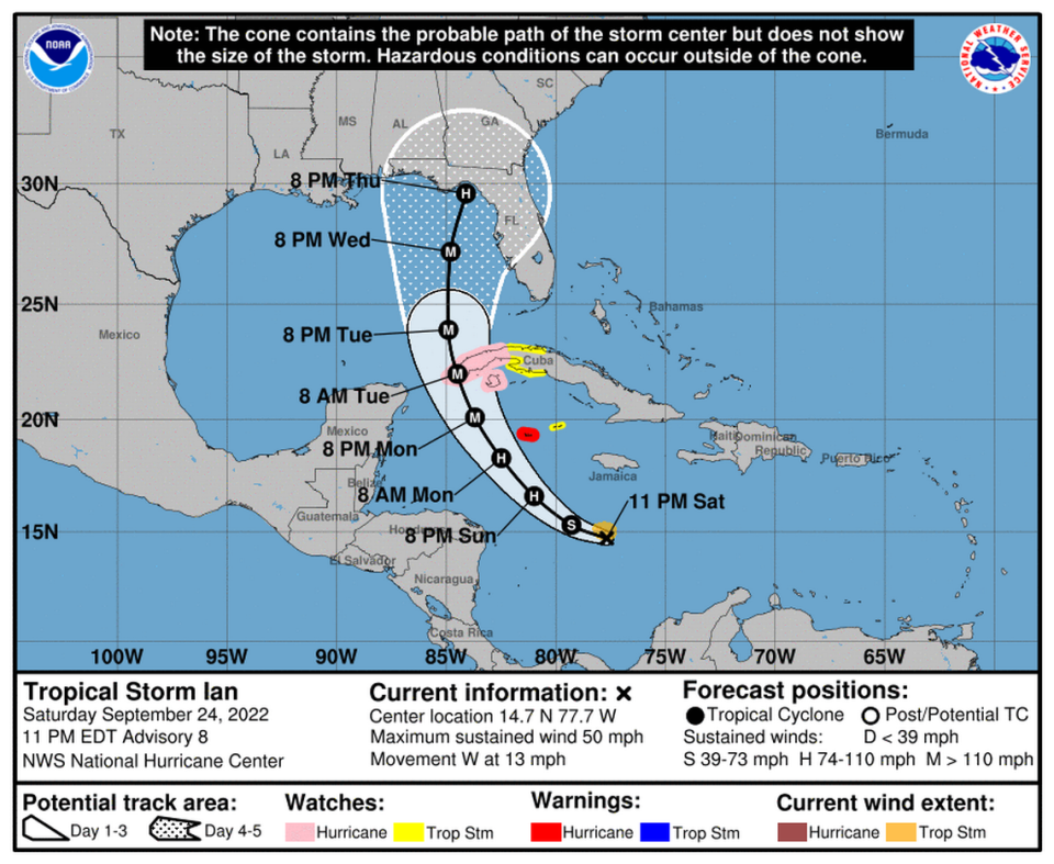
11 p.m. Saturday: Ian could be Cat 4, track still uncertain
The uncertainty in the forecast track for Tropical Storm Ian remains as the storm intensifies, now carrying 50 mph winds.
Ian could now strengthen to a Category 4 storm with maximum winds of 140 mph over the Gulf in about three days, the National Hurricane Center said.
As of the 11 p.m. advisory, computer models continued to disagree, with a spread of about 200 miles for possible landfall of the center of the storm.
Manatee County and all of the Tampa Bay area remain in the forecast cone of uncertainty and could potentially see a direct landfall. The Hurricane Center’s official track continues to move west, and landfall in the Panhandle is also a possibility.
“Regardless of Ian’s exact track and intensity, there is a risk of dangerous storm surge, hurricane-force winds, and heavy rainfall along the west coast of Florida and the Florida Panhandle by the middle of next week, and residents in Florida should ensure they have their hurricane plan in place, follow any advice given by local officials, and closely monitor updates to the forecast,” a hurricane forecaster said.
Ian is expected to become a hurricane by Sunday as it skirts the western coast of Cuba.
President Joe Biden declared a state of emergency in Florida Saturday evening for 24 counties including Manatee County.
8 p.m. Saturday: Track continues westward shift
The uncertainty with the forecast for Tropical Storm Ian continues to grow as the track continues to shift westward.
As of the 8 p.m. intermediate advisory, Ian continues to organize over the warm waters of the central Caribbean. The latest forecast puts the eye, or center, of the storm parallel to Manatee County sometime between Wednesday afternoon and Thursday as a major hurricane and later weakening before making landfall somewhere in the Big Bend.
The uncertainty of the storm’s exact tract continues to grow with computer models showing a range of 200 miles.
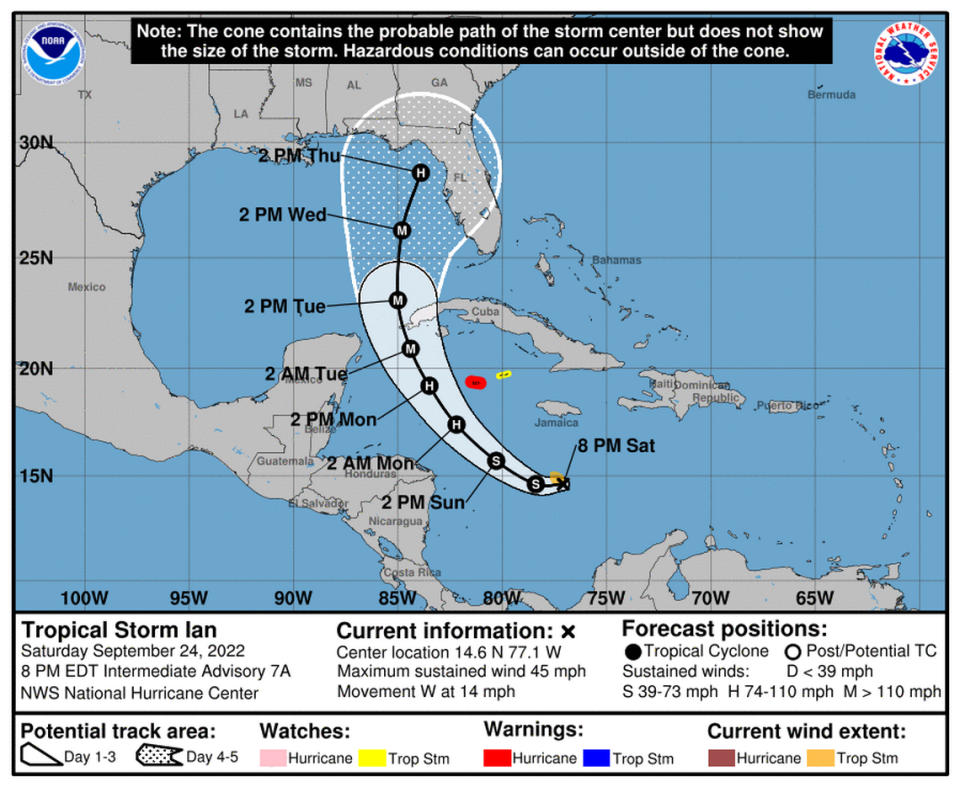
5 p.m. Saturday: Forecast landfall shifts north of Manatee
Manatee County remains in the cone of uncertainty as the latest models from the National Hurricane Center shift west.
As of the 5 p.m. advisory, the forecast has Ian making landfall as a hurricane sometime Wednesday north of Cedar Key — in Levy County. Computer models showed a lot of uncertainty with the forecasted path, however, with a spread of nearly 180 miles.
But regardless where the storm’s center makes landfall, Manatee County will likely be on the “dirty side” of the storm, the right and more wet side of a tropical storm.
The Bradenton City Council has called emergency meeting for 11 a.m. Sunday, where they are expecting to declare a state of emergency.
Residents are encouraged to sign up for CodeRED, an emergency notification service — online at bradentonfl.gov or by texting MyBradentonFL to 99411 from a smartphone. Anyone who needs help signing can call 941-932-9497.

2 p.m. Saturday: Manatee County declares a state of emergency
The Manatee County Board of Commissioners declared a local state of emergency ahead of Ian during an emergency meeting Saturday afternoon.
Gov. Ron DeSantis already declared a state of emergency for the entire state ahead of the storm, with most of Florida in the forecast cone of uncertainty.
Sunday is expected to be the major decision day for state emergency management officials, County Administrator Scott Hopes told the four county commissioners present. Hopes and Public Safety Deputy Director Steve Litschauer said decisions will be made after Sunday’s 1 p.m. briefing with the state.
“This is the time to get their plans together. This is the time to get their supplies together, to know what their evacuation level is,” Litschauer said after the meeting. “We don’t want send people in panic yet.”
“There is still a lot to do and a lot of information to obtain, so day by day we are evaluating what the National Hurricane Center produces, the National Weather Service produces.”
Litschauer said Manatee County residents have a couple of days to prepare before any local decisions.
Four commissioners — Kevin Van Ostenbridge, Vanessa Baugh, George Kruse and Reggie Bellamy — were present for the meeting and voted unanimously to declare a state of emergency.
Commissioner Vanessa Baugh reflected on how many times she and others on the board have had to make these declarations.
“Every time we do this it’s eerie and scary,” Baugh said, echoing sentiments from Bellamy.
10 a.m. Saturday: Now is the time to prepare
While Ian remains far from the Gulf of Mexico, Bradenton area officials are encouraging people to start preparing in case the storm heads this way.
On Saturday, Sunday and Monday, free sandbags will be given out at several sites in Bradenton and Manatee County.
A new location to get sandbags at Buffalo Creek Park, 7550 69th St E, Palmetto, on the northeast part of the parking lot that borders the golf course, was announced by Manatee County government Saturday in a tweet.
“Anyone who may be concerned about flooding or residents of flood-prone areas should start making plans to stay with family or friends outside of that area,” said Steve Litschauer, Manatee County’s public safety deputy director.
5 a.m. Saturday: Storm predicted to intensify
Ian’s predicted wind speed at landfall increased to 115 mph.
A Hurricane Hunter aircraft explored Ian Saturday morning, according to the National Hurricane Center, which will put out more information on Ian’s structure and strength through the day.
Ian is expected to move north and northwest by Sunday. Ian will be brought into the southeast Gulf of Mexico and near or over western Cuba as a result. The forecast shows that the storm will start to re-curve into Florida late in the time frame.
As it advances west through the Central Caribbean, Ian may strengthen, according to the National Hurricane Center’s advisory. In the Cayman Islands, hurricane conditions might develop early on Monday.
In areas with higher altitudes, notably over Jamaica and Cuba, Ian may bring torrential rain, flash floods, and perhaps mudslides, according to the hurricane center.
Here are the 5 am EDT Saturday Key Messages for Tropical Storm #Ian. Get the latest storm information at https://t.co/tW4KeGdBFb pic.twitter.com/QaHIoxDjtT
— National Hurricane Center (@NHC_Atlantic) September 24, 2022
New sandbag location!
Buffalo Creek Park, 7550 69th St E, Palmetto 34221 (north east part of parking lot that borders the golf course). https://t.co/kWJkwXg8ju— Manatee County Government (@ManateeGov) September 24, 2022

