Live updates: Major flooding and power outages hit North Jersey as rainstorm slams region
A massive rainstorm that hit Sunday night continued to batter North Jersey into Monday with major flooding and power outages wreaking havoc on the region.
Flooding shut down highway lanes through the state Monday morning ahead of the prime commuting hours.
Thankfully, after over 5 inches of rain fell in some areas, relief from the storm finally arrived around 2 p.m. as the rain slowed down or stopped across the state and the National Weather Service radar showed the storm finally moving out of New Jersey and heading north.
However, flood watches and warnings are still in place in many areas, with some not expiring until at least Tuesday, so keep an eye on your local weather announcements and stay vigilant of your surroundings while out and about.
Our staff has been bringing you updates throughout the day on the storm. Here's the latest:
Free water and ice for JCP&L customers still without power
JCP&L has posted on social media that water and ice is available to customers without power due to the storm. View the list of locations: http://spr.ly/6012RTAJa. Please visit the Customer Service desk at the store to receive a voucher.
Locations include Acme stores in Denville, Boonton, Randolph and elsewhere in Morris County; Kings stores in Morristown, Chatham, Mendham and other Morris locations; Shop Rites in Chatham and Rockaway in Morris and West Milford in Passaic County; and various Sussex County stores.
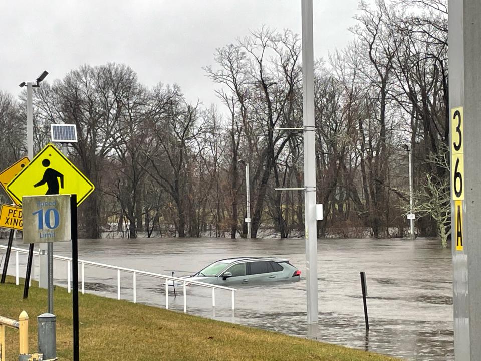
Hundreds of properties in Pequannock face flood danger
Nick DeStefano, former member of Pequannock Flood Committee, estimates the township has approximately 400 properties in danger of severe flood damage. About 100 have been mitigated in some way, including those that have been elevated above flood levels.
This storm, DeStefano said, could have been even worse. "The rain gauge said we got 5 inches of rain," he said. "Fortunately, the reservoir levels were low or we could be looking at an Irene-like event."
Irene he said holds current flood record for Pequannock, when the flood level reached 25 feet. "It is almost like clockwork," he said. "Major floods happen almost every 15 years."
Pequannock Councilman Ryan Herd said he was out Monday evening helping evacuate residents along the Pompton River. He said while 65 homes have been raised above the flood level so they won't have to be evacuated, other residents will need to be rescued.
"The flooding snuck up on us," Herd said. "We first got word around 11 a.m. that Route 23 was flooding."
Later Monday the Village section of the township became a concern. Fire companies are going to door to door to warn residents, he said, and a reverse-911 was issued. "People are being advised to move their cars and evacuate if need be," he said.
The Hamburg Turnpike bridge in Pompton Lakes, meanwhile, has been closed in both directions.
-Matt Fagan
Flooding for Mahwah into Wednesday
Mahwah is expected to have some continued flooding Monday night into Wednesday because of Ramapo River levels reaching flood stage. The river reached 11.2 feet at 6:30 p.m. Monday, well above the moderate flood level of 8 feet for the river there.
The record flood height is 15.78 feet for the Ramapo in Mahwah.
It is forecast by USGS to continue rising to 11.5 feet overnight, then start dropping but not recede to below flood stage until 7 a.m. Wednesday.
Lincoln Park evacuations, Denville inundated
In Lincoln Park, police urged residents in low-lying areas to evacuate. In Dover, state police helped the town respond to widespread downtown flooding.
Denville Business Administrator Steven Ward said it was “probably the worst flooding we've experienced since August of 2011 during Hurricane Irene. This is the first time we've had to close one of the downtown streets, Second Avenue, due to flooding.”
Calls for some evacuations in Pequannock
Pequannock Township has been calling and notifying some residents that flood waters may reach their property and that they are advised to leave and move their cars.
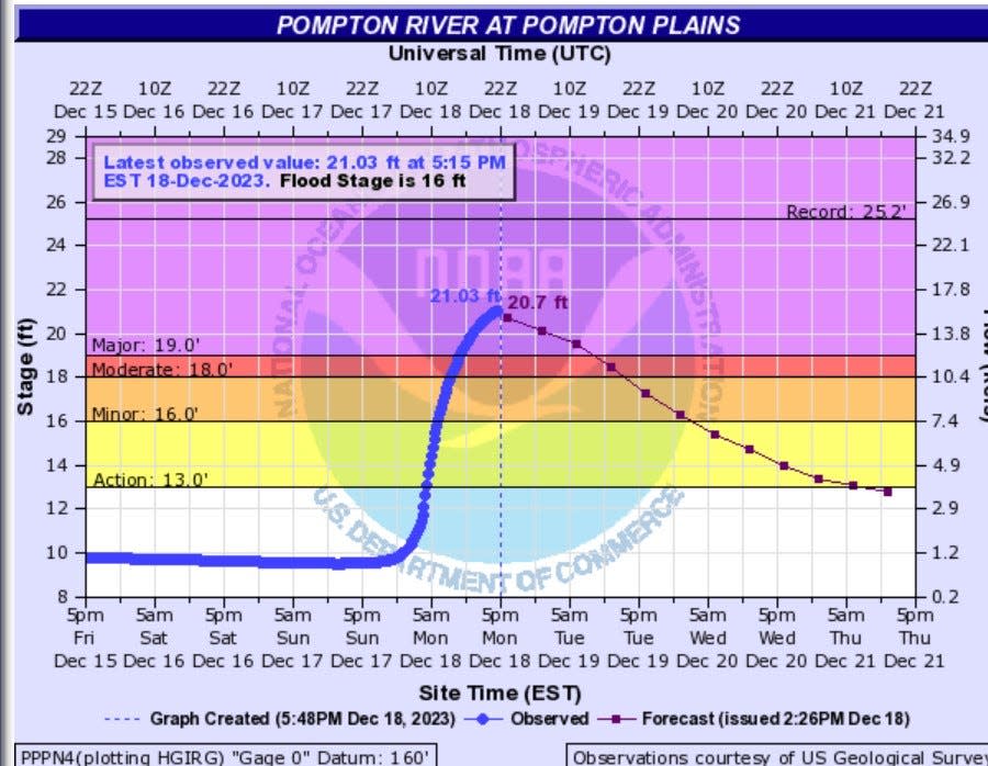
The Pompton River in Pompton Plains within Pequannock Township crested at 5:15 p.m. at 21 feet Monday — well above the flood stage of 16 feet. It had started to drop by 6 p.m., to 20.7 feet, but was not forecast to return below the flood action level of 13 feet until 5 p.m. Thursday, according to the U.S. Geological Survey.
The river’s highest flood stage ever there was 25.24 feet in August of 2011.
Pequannock Township’s website says that Rt. 23 is being closed in both directions. The impact of the flood is expected to significantly impact the Rt. 23 corridor and those properties in proximity to the East Ditch and West Ditch.
Sections of the Village Neighborhood may be impacted, as well as properties along Rt. 23 Northbound from the Baymont Hotel to Crestmont Toyota.
-James M. O'Neill
State of emergency in Paterson
Paterson Mayor Andre Sayegh declared a state of emergency in the city Monday afternoon. Arch and Temple streets remain closed. Northbound lanes of Route 20 between 8th and 10th avenues remain closed by the state DOT, Sayegh said.
Cars floating in Denville
In Denville, one of the hardest hit towns in Morris County, the Rockaway River swelled over its banks and into homes along Riverside Drive and the parking lots outside Saint Clare’s hospital, where a handful of cars sat in 2 feet of water.
Sue Banks, owner of the Faith and Begorra boutique on Broadway, was surprised by the severity of the storm. Her shop escaped flood damage but suffered roof leaks that ruined some merchandise.
Still, she considered herself lucky based on what she saw during her morning commute into town.
In Dover, she said, "They had cars just floating on Blackwell Street. They looked like bumper cars. They were abandoned and literally floating.” The Lakeland Bus garage in Dover near Route 46 was also inundated. On her way into Denville, Main Street was closed off.
While Denville’s business district escaped serious flooding, local businesses will feel the impact of a storm that hit in peak shopping season, Banks said.
"It's probably the worst time of the year, the week before Christmas, to have flooding all around us because people would be shopping," she said. Instead, only a "dribble of people" were coming in due to the weather conditions on Monday afternoon.
-Gene Myers
Potential flooding at North Jersey rivers
Several North Jersey rivers were cresting above flood stage Monday afternoon according to USGS stream gauge data. Others won’t reach minor flood stage until Tuesday evening.
The Hackensack River at New Milford was at 9.2 feet Monday at 4:15 p.m., above its normal minor flooding threshold of 6 feet. The Hackensack at River Vale was at 8 feet at 4:15 p.m., above its minor flooding mark there of 5.3 feet.
The Pascack River in Westwood was at 5.3 feet at 4:40 p.m., slightly above its normal minor flooding stage of 5 feet.
The Rockaway River in Boonton below the reservoir was at 2.9 feet around 8 a.m. Monday. It was expected to surpass its flood action level of 3.5 feet, reaching 3.8 feet by noon.
The Passaic River in Pine Brook was at 18.7 feet Monday morning. It is expected to reach 20.8 feet – above its minor flood threshold of 19 feet — on Tuesday evening.
− James M. O'Neill
Power outages in North Jersey
The storm knocked out power for thousands of people Monday morning. Some of the outage numbers, by customers affected, as of 3 p.m. include:
Bergen County: 661
Passaic County: 883
Essex County: 431
Hudson County: 74
Morris County: 2,550
Sussex County: 1,459
How much rain has fallen in North Jersey so far
Up to 4-to-5 inches of rain fell in parts of North Jersey. North Haledon and Oakland went over 5 inches, according to Bob Ziff of the North Jersey Weather Observers. See the full list here.
Bergen County rain response
The Bergen County Office of Emergency Management team is on call and stationed throughout the county and working with local law enforcement. The high water rescue task force is also on call and have already been deployed to a water rescue in Hillsdale, where a local evacuation order was put in place, said Derek Sands, deputy chief of staff for Bergen County Executive Jim Tedesco said.
There has been moderate flood damage in some of the county parks reported this morning. “We are aware that this afternoon the tide cycle is on high-tide and there are certain areas that we need to watch out for,” Sands said.
Most of the county has already received 3 inches of rain with another inch expected throughout this afternoon. Excessive runoff is resulting in flash flooding of rivers, small creeks, streams and other low lying and flood prone areas, a bulletin issued by the County OEM said.
Bergen County officials have been in contact with Veolia Water company representatives and all three dams are currently spilling. Since all dams are spilling the rain fall will be passed down stream. There is special attention to the Hillsdale, Westwood, Oradell, New Milford and River Edge area with major flooding expected through Tuesday.
− Kristie Cattafi
Hoboken rain conditions
Hoboken is usually one of the worst hit New Jersey communities when it comes to flooding.
But by 8 a.m., most streets on the city’s flood-prone westside were open. The Hudson-Bergen Light Rail was running on a regular schedule through Hudson County with umbrella-toting commuters tiptoeing past large puddles to catch their train.
Not everywhere was passable. Traffic was halted at Paterson Plank Road in Jersey City Heights due to flooding down the hill in Hoboken.
− Scott Fallon
When will the rain stop?
Rain appears in the forecast until 2 to 3 p.m. depending on your exact spot.
National Weather Service meteorologist James Tomasini expects the rain to slowly taper off through this morning and for North Jersey to be dry by the late afternoon.
As for wind, it will begin to slowly die down. Gusts up to 35 mph may continue through the day and are expected to reduce throughout the night.
“The storm is ongoing, and we are still gathering reports,” said Tomasini. “If you come across any flooded roads, do not drive. Be on the lookout for additional flood or flash flood warnings as the storm continues.”
School closings
West Essex and Lincoln Park are among several schools that closed or had a delayed opening Monday due to the rain.
Mahwah, Allendale and Teaneck flooding
Mayor James Wysocki said township was "hit pretty hard this morning," including several water rescues from flooded cars and "significant water damage." Business Administrator Ben Kezmarsky said flooding occurred in predictable and unusual locales. Power lines are down. Elementary schools had an early dismissal due to a power outage. Trees were down in roadways, and across properties. Many basements were flooded. DPW, Police Department, and Emergency Services were out in force.
Allendale is reporting flooding of railroad underpasses on West Crescent between Myrtle Avenue and West Allendale Avenue, and West Orchard Street between Franklin Turnpike and Allen Street. The area near the entrance to Crestwood Lake on West Crescent Avenue at West Allendale Avenue is also closed due to flooding.
In Teaneck West Englewood at Hudson Road is closed due to down trees and low hanging wires. Windsor Road between Route 4 and West Englewood Avenue is closed due to flooding.
− Marsha Stoltz
North Jersey traffic Closures on I-80, I-287; Routes 46, 3, 94; Devils at Prudential
Hawthorne flooding
At least four sections of road were cordoned off to motorists in a low-lying portion of Hawthorne, said Mayor John Lane.
The 1st Ward is notoriously prone to flooding of Goffle Brook, and Lane said the overnight storm was a “little worse” than previous rain events that the borough has experienced. “It floods all the time,” he said. “The avenue that the brook takes isn’t wide enough to handle all the water.”
Most of Wagaraw Road was closed to traffic, Lane said. And sections of Goffle Road and Rea Avenue were still shut down as of 11 a.m., he said. “One at a time, now, they’re opening up,” he said. “The problem is that there’s a lot of debris in the street.”
It may be hours before the roads are passable. A public works crew was deployed to the flooded streets with a front-end loader to clean up tree branches and other hazards, Lane said.
The brook, a Passaic River tributary, flows under the old textile mill at 179 Goffle Road. Lane said the owner of the building, now a warehouse and a plant for small-batch concrete, has tried to unclog the part of the stream that runs through the 7.3-acre property.
− Philip DeVencentis
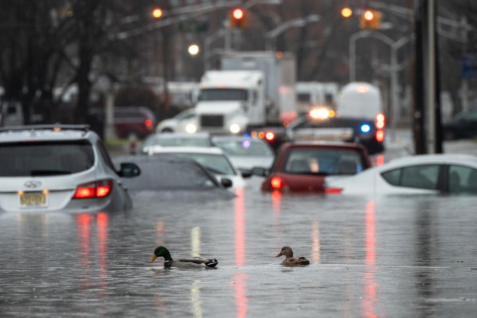
Passaic County flooding
In Clifton, one persistent flooding area Clifton Avenue, around the railroad bridge and Anzaldi Recreation Complex had a some significant flooding, which is not unusual. During Tropical Storm Ida, severe flooding damaged numerous properties in area and led the condemnation of medical arts building.
In Passaic, Fire Chief Pat Trentacost reported “major flooding.” The following streets are completely flooded out and are closed: River Driver at Aycrigg Avenue, River Drive at Van Houten Avenue, Pennington Avenue at Benson vAenue, Lafayette Avenue at Route 21, State Street and Route 21 Washington Street at Hope Avenue and Main and Brook avenues.
“High tide is at 12:33 p.m.“ Trentacost said. “We are concerned.”
− Matt Fagan
Morris County storm response
In Morris County, homeowners awoke to soggy basements in parts of Dover, Lincoln Park, Parsippany, Rockaway Township and other communities, as the storm drenched low-lying areas. In the Indian Lake section of Denville, the waters overtopped docks and spilled into the narrow streets around the village.
"We responded into Dover earlier this morning at the request of the Dover Fire Department to assist with a number of flooding related emergencies, people that were either trapped in vehicles or flooding waters,” said Jeff Paul, director of the county’s Office of Emergency Management. “That similar type of event did happen in other municipalities throughout Morris County.”
In Pequannock, the Pompton River had already surged above flood stage at 16.4 feet as of Monday morning and was expected to crest at just below 18 feet after midnight on Tuesday.
Flooding caused intermittent closures of local roads throughout the county, as well as along Route 10 between Whippany and Troy-Hill roads in Parsippany, with the worst conditions reported in northern and western Morris County.
Residents are advised to stay indoors when possible, due to hazards like uprooted trees and standing water, county Sherriff James Gannon said.
"Stay in as much as you can," Gannon said. "There are trees that are just uprooted and have fallen into the roadway and there’s standing water in the streets, you don't know the depth of it."
− Gene Myers
Hackensack flooding
In Hackensack, flooding caused the closure of several roads, including Main Street and Romaine Court, Kinderkamack Road, South Newman Street, Essex Street and Green Street, Lodi Street and McKinley Street, and Main Street and South Lake Drive.
Downed wires have been reported at Club Way and the Esplanade and Ross Avenue near Prospect Avenue, Capt. Michael Antista said.
The Hackensack Fire Department warned people not to drive through flooded areas and avoid unnecessary travel until the flooding subsides.
− Megan Burrow
Sussex County flooding
In Sussex County, Wykertown Road (County Route 629) between Frankford and Wantage is closed.
The National Park Service has closed several roads within the Delaware Water Gap National Recreation Area as well as the length of the Delaware River from Port Jervis at the New Jersey/Pennsylvania/New York border through the water gap.
The river is expected to rise to more than 20 feet as measured at the gauge in Montague by mid-day Tuesday. Flood stage at that gauge site is 25 feet, however low-lying areas and islands within the park may see some floding.
Officials closed River Road between Park Headquarters and the Hialeah Picnic Area just north of the hamlet of Shawnee and advised that Route 209, the main road on the Pennsylvania side of the river could see some flooding from the mountain sides, especially near creek and stream crossings.
In New Jersey, the park has closed Old Mine Road between Millbrook Village and Worthington State Forest. Blue Mountain Lakes Road is also closed until further notice.
− Bruce Scruton
Check back for updates as the storm continues.
This article originally appeared on NorthJersey.com: NJ flooding and rainstorm slam North Jersey with power outages

