Live updates: Manatee orders evacuation as Tropical Storm Idalia approaches Bradenton
Residents and emergency officials in Manatee County are preparing for the impact of a hurricane as Tropical Storm Idalia strengthens in the Gulf of Mexico.
The latest weather forecast shows Idalia just south of Cuba, but the storm is expected to quickly gather strength as it travels northeast over warm water in the Gulf of Mexico.
On Monday, residents bounced around town, gathering hurricane supplies, sandbags and gas to prepare for the storm.
Manatee County officials also announced a mandatory evacuation order in Level A. Voluntary evacuation orders have also been set for Level B. The orders go into effect at 2 p.m.
“We’re expecting significant storm surge along the barrier islands and coastal communities for Idalia, with the earliest arrival predicted for Tuesday,” said Manatee County Public Safety Director Jodie Fiske in a news release. “This is a very dangerous track that we all need to be aware of.”
There are also three shelters opening at 2 p.m. They are:
Virgil Mills Elementary School, 7200 69th St. E., Palmetto
Jesse P. Miller Elementary School, 6014 Third St. W., Bradenton
Freedom Elementary School, 9515 State Road 64, Bradenton
6 p.m. Monday: SRQ airport open Tuesday
Sarasota-Bradenton International Airport announced that it would remain open and operational on Tuesday.
However, individual flights could still be affected by the weather. Fliers are advised to check with their airline directly for updates.
Other regional airports decided to close ahead of Idalia’s arrival.
Tampa International Airport will close at 12:01 a.m. Tuesday until further notice.
St. Pete-Clearwater International Airport will close at 3 p.m. Tuesday and plans to reopen at 3 p.m. Wednesday.
5 p.m. Monday: Idalia to become hurricane Monday night
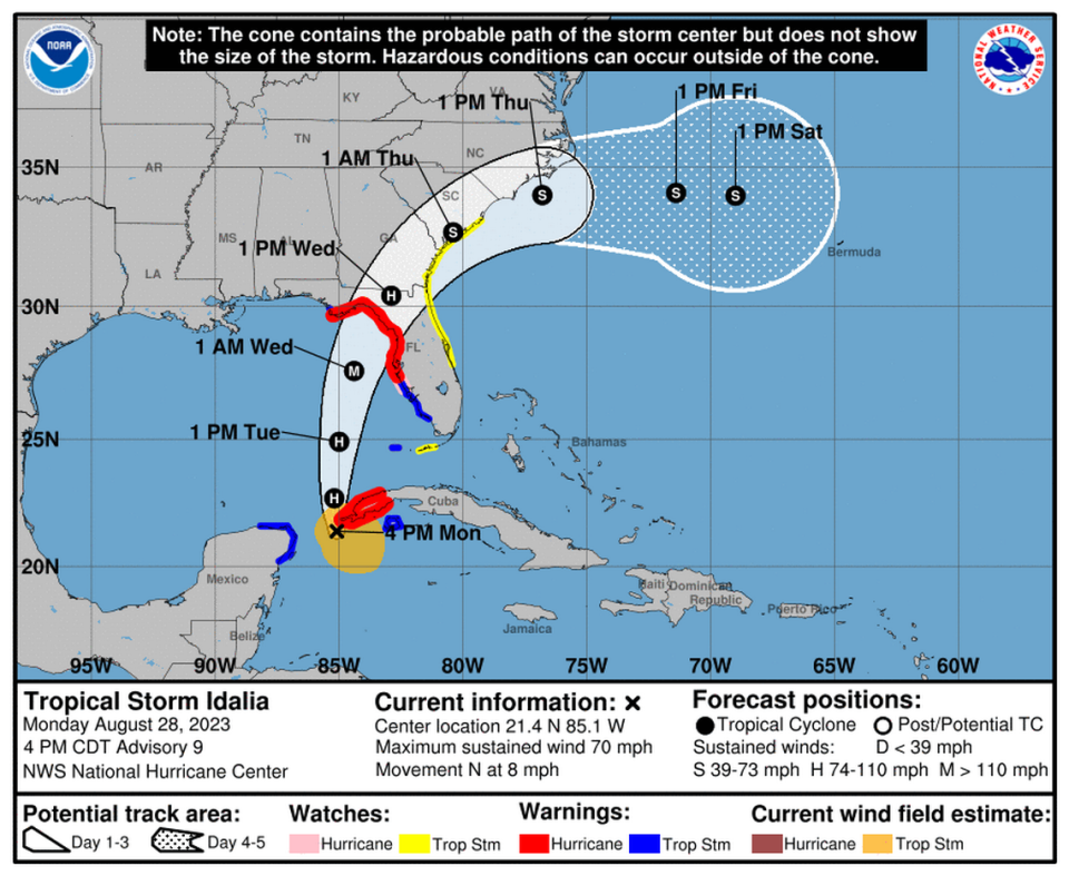
Tropical Storm Idalia is currently about 35 miles south of Cuba’s western tip with maximum sustained winds of 70 mph and poised to become a hurricane Monday evening, the National Hurricane Center said in a Monday afternoon advisory.
The storm is moving around 8 mph. It is predicted to pass over or near western Cuba on Monday night before entering the eastern Gulf of Mexico on Tuesday, where it is expected to rapidly intensify to a Category 3 hurricane within 36 hours.
The latest Idalia forecast has the storm tracking north in the Gulf, heading in a north by northeast direction Tuesday and reaching Florida’s Gulf coast on Wednesday.
The projected landfall point continued to shift west with the latest model, placing Tampa Bay, Bradenton and Sarasota just outside the cone of uncertainty.
But hurricane forecasters warn that the track could still easily change.
“It is still worth stressing that only a small deviation in the track could cause a significant change in Idalia’s landfall location in Florida due to the paralleling track to the west coast of the state,” the Hurricane Center said.
A large portion of the Gulf Coast is under a hurricane warning, with potential impacts including wind, heavy rain, storm surge and tornadoes.
“Idalia is forecast to move into an area very susceptible to storm surge, and regardless of the cyclone’s landfall intensity, there is increasing confidence of a significant storm surge event,” the Hurricane Center said.
2 p.m. Monday: Manatee County warns of storm surge threat
Manatee County leaders urged residents to finish hurricane preparations now during an emergency update on Monday afternoon.
They also warned that storm surge is the main threat anticipated from Idalia.
A surge of 5 to 11 feet is possible along Manatee County’s coast, Commissioner Kevin Van Ostenbridge said.
“Idalia is not Ian,” Van Ostenbridge said. “Wind is not going to be our primary concern. Our primary concern at this point is the storm surge. Coastal residents need to heed our warnings.”
A “king tide” around noon on Wednesday will mean that water levels are exceptionally high, furthering the threat of storm surge.
A mandatory evacuation order went into effect at 2 p.m. for Level A, which includes low-lying coastal areas and all mobile homes, regardless of location. A voluntary evacuation is in effect for Level B.
“We do not want people traveling in the dark in the rain. That’s why we enacted (evacuations) early,” said Steve Litschauer, Manatee County’s Emergency Management Chief. “Please heed our warnings.”
Litschauer said the latest local forecasts call for sustained winds as high as 50 mph with gusts up to 75 mph and 4 to 10 inches of rain.
“Please pay attention to the track,” Public Safety Director Jodie Fiske said. “Just because you get one forecast does not mean that it will stay the same.”
Van Ostenbridge said Piney Point and Lake Manatee are in “good shape” ahead of the storm.
Other things to know:
There will be no yard waste or recycling pickup for Manatee County customers this week. Trash pickup will be adjusted as follows: Tuesday pickup will move to Thursday, Thursday pickup will move to Friday and Friday will move to Saturday.
The city of Bradenton, which handles trash pickup separately, will also pause garbage pickup on Tuesday and Wednesday. However, city staff will continue to collect yard waste, such as branches and clippings.
The Lena Road Landfill will be closed Tuesday and Wednesday, reopening Thursday.
All MCAT buses will be taken off the roads sometime Tuesday. The county will keep them running until tropical-storm-force winds arrive.
Manatee County parks are closed for the duration of the storm
Lifeguards are not patrolling county beaches
2 p.m. Monday: Manatee Schools to close Tuesday and Wednesday
The School District of Manatee County announced that all schools and support sites will be closed Tuesday and Wednesday, due to several schools being scheduled to open as shelters Monday afternoon.
All extracurricular activities and athletic events, including Extended Day programs, are set to end Monday evening at 6 p.m. and will resume once school reopens.
Bradenton Christian School and Saint Stephen’s Episcopal School followed suit and announced on Facebook that they will also be closed Tuesday and Wednesday.
Information regarding hurricane makeup days, if needed, will be communicated once school resumes, the district said on Facebook.
For more information, you can check the district website at https://www.manateeschools.net.
12:20 p.m. Monday: Manatee under Idalia evacuation order
In an update to the Manatee County Commission, local public safety officials said residents need to take Tropical Storm Idalia very seriously. The storm is set to rapidly intensity into a hurricane over the next several hours and will pose a significant threat to the Bradenton area.
“Do not focus on the eyewall,” said Fiske, who noted that the storm will create flooding, high wind speeds and possibly tornadoes in the area. “You need to focus on the entire storm.”

Emergency Management Chief Steve Litschauer also expressed concern about Idalia’s path during a brief press conference. He said the storm, expected to make landfall as a Category 3 hurricane, could “absolutely” be more dangerous than Hurricane Ian based on the latest forecast.
“This storm is changing very rapidly and as it gets into the Gulf, it’s become very serious. We’re anticipating up to a Category 3 or maybe even a 4,” Litschauer said. “Be prepared and heed our evacuation orders.”
Earlier Monday, Manatee County officials issued a mandatory evacuation for residents who live in Level A, including all mobile home parks. A voluntary evacuation order has also been issued for Level B residents.
Between 30,000 and 50,000 residents are expected to be impacted by the county’s evacuation order, Litschauer said.
Visit www.MyManatee.org/ManateeReady to check your evacuation level and view other hurricane preparedness information.
12:15 p.m. Monday: New College cancels class
New College of Florida canceled classes and extracurricular activities (including athletics) for Tuesday. New College’s interim president Richard Corcoran made the announcement in a letter to the college’s community, citing caution at the time.
Classes are projected to resume Wednesday if the campus does not suffer damage or power loss from Tropical Storm Idalia.
Faculty should stay home while classes are canceled and campus staff should contact their supervisor to determine if they are to report to campus or stay home on Tuesday.
12 p.m. Monday: President Biden declares Idalia emergency
President Joe Biden approved an emergency declaration for Florida. This means the Federal Emergency Management Agency (FEMA) was made available to help with disaster assistance to supplement state, tribal and local response efforts from Tropical Storm Idalia.
FEMA is authorized to coordinate disaster relief efforts in the following counties:
Alachua
Bay
Calhoun
Charlotte
Citrus
Columbia
DeSoto
Dixie
Franklin
Gadsden
Gilchrist
Gulf
Hamilton
Hardee
Hernando
Hillsborough
Jefferson
Lafayette
Lee
Leon
Levy
Liberty
Madison
Manatee
Marion
Pasco
Pinellas
Polk
Sarasota
Sumter
Suwannee
Taylor
Wakulla
According to a news release, “FEMA is authorized to identify, mobilize and provide at its discretion, equipment and resources necessary to alleviate the effects of the emergency. Emergency protective measures limited to direct federal assistance, under the public assistance program will be provided at 75% federal funding.”
FEMA’s federal coordinating officer for the recovery operations in affected areas is Brett Howard.
11 a.m. Monday: Manatee upgraded to Hurricane Warning
Manatee County was upgraded to a Hurricane Warning in the latest National Hurricane Center update. The warning stretches from the middle of Longboat Key northward to the Ochlockonee River in the Big Bend region.
“A Hurricane Warning means that hurricane conditions are expected somewhere within the warning area,” the National Hurricane Center said. “A warning is typically issued 36 hours before the anticipated first occurrence of tropical-storm-force winds, conditions that make outside preparations difficult or dangerous. Preparations to protect life and property should be rushed to completion. A Hurricane Warning means that hurricane conditions are expected somewhere within the warning area, in this case within the next 12-24 hours. Preparations to protect life and property should be rushed to completion.”
The latest forecast has Idalia’s path coming through the Gulf of Mexico as a hurricane off Tampa Bay at 7 p.m. Tuesday. Idalia’s cone has it traveling northeast hitting anywhere from Pinellas County to the Big Bend region, and is currently projected to become a major hurricane landing in the Big Bend region.
9 a.m. Monday: Manatee under Hurricane Watch
Tropical Storm Idalia is expected to turn into a hurricane when it nears western Cuba later today, according to the National Hurricane Center.
Idalia is currently about 90 miles south of Cuba’s western tip with winds topping at 65 miles per hour, the National Hurricane Center said in its Monday morning update.
A Hurricane Watch is in effect for Florida from Englewood to Indian Pass. That includes Manatee County.
The Saffir-Simpson Scale determines hurricane categories based on wind strength. Once a storm reaches wind strengths of at least 75 miles per hour, it is upgraded from a tropical storm to a hurricane.
The latest Idalia forecast has the storm tracking north in the Gulf of Mexico. Idalia’s path is expected to head in a north by northeast direction Tuesday and reaching Florida’s Gulf coast on Wednesday, the National Hurricane Center said.
With Idalia comes storm surge and high winds, the National Hurricane Center said.
“The combination of a dangerous storm surge and the tide will cause normally dry areas near the coast to be flooded by rising waters moving inland from the shoreline,” the National Hurricane Center said.
The National Hurricane Center projects 4 to 7 feet of storm surge to impact areas near the Anclote River, by Tarpon Springs, and the middle of Longboat Key, while areas south of there to Englewood should see 3 to 5 feet of storm surge.
Storm surge happens when “water is pushed toward the shore by the force of the winds moving cyclonically around the storm,” the National Hurricane Center said. “The impact on surge of the low pressure associated with intense storms is minimal in comparison to the water being forced toward the shore by the wind.”
Gov. Ron DeSantis said Monday that evacuation orders will be issued in several Gulf coast counties, ranging from Pinellas or Manatee County through the Big Bend region, where Florida’s panhandle transitions into the peninsula southeast of Tallahassee, according to a Miami Herald report.
“This is going to be a powerful hurricane and this is absolutely going to impact the state of Florida in many many ways,” DeSantis said as he urged Floridians to prepare for the storm and protect themselves and their families.

