Wednesday storms: National Weather Service investigates possible tornadoes in Jackson area
Editors note: This article is provided free to all readers as a public service by the Clarion Ledger and Hattiesburg American. Please consider subscribing to support local journalism.
This story will be updated throughout the day. Check back periodically for the latest severe weather information.
8:15 p.m.: Tornado warning continues for south Forrest County
South Forrest County is under a tornado warning until 8:30 p.m., weather service officials reported.
The storm system was reported over Maxie, seven miles northwest of Wiggins, moving northeast at 55 mph.
Other rounds of severe thunderstorms and possible tornadoes were reported eastern Mississippi including the towns of Shubuta and Quitman heading into Meridian and Lauderdale County.
On the Coast, parts of Hancock County are under a tornado warning until 9 p.m., including the city of Waveland.
7:15 p.m.: Tornado warning issued for Forrest, Lamar counties
Tornado sirens began blaring and warnings popped up on cellphones as the National Weather Service in Jackson issued a tornado warning for Forrest and Lamar counties.
The warning remains in effect until 8:15 p.m.
A tornado watch for the area has been extended to 9 p.m.
6:30 p.m.: Southaven reports warehouse roof collapse
In north Mississippi, the Southaven Police Department posted on Twitter that a roof had collapsed on a warehouse. The department told people to avoid the area of Marketplace, Airport and Marketplace Drives and Airways.
The police department later posted an update on Facebook: "The building has been evacuated and everyone is safe and accounted for."
— Memphis Commercial Appeal reporters Micaela A Watts and Dima Amro
Severe weather: See the power outage map for Mississippi as storms move across Deep South
6:25: Residents talk about brush with Jackson tornado
Roosevelt Harris was on Winter Street when the storm moved through Jackson near Battlefield Park in Jackson.
“We had a bad windstorm,” Harris said. “Blowed all the trees down and all the power lines down. It was terrible. It happened so fast. It was here and just gone.”
Cassidy Webb also was on Winter Street when the storm came through.
“It happened quick as hell,” Webb said. “It picked that shed up while that (unidentified) man was still in there. He is lucky to be alive.”
— Clarion Ledger reporter Ross Reily
6:15 p.m. Severe thunderstorm warning issued for south-central Mississippi
A severe thunderstorm warning was issued for Simpson, Lawrence, Covington and Jefferson Davis counties until 7 p.m.
The area remains under a tornado watch until 8 p.m.
6:10 p.m.: Starkville under tornado, severe thunderstorm warnings
The National Weather Service in Jackson placed the Starkville area under tornado and severe thunderstorm warnings until 7 p.m. Residents there are urged to take shelter.
The tornado warning includes Oktibbeha and Clay counties.
The thunderstorm warning includes parts of Choctaw, Noxubee, Oktibbeha, Winston, Webster and Clay counties.
The storm system is moving northeast at 60 mph. A tornado cannot be ruled out, officials say.
LIVE update on tornado warned shelf cloud approaching Bentonia MS with tornado debris signature. Tornado lifted on approach to Bentonia and Flora @accuweather pic.twitter.com/3J2EUFDPxZ
— Reed Timmer (@ReedTimmerAccu) March 30, 2022
6 p.m.: Hinds Count Emergency Management says no injuries reported in tornado
Hinds County Emergency Management officials say no injuries have been reported as of 5:50 p.m. after a tornado was spotted in downtown and southwest Jackson.
One of our local churches has already felt the brunt of the weather event in south Mississippi. This is just from wind gusts, before the bad squall line arrives. pic.twitter.com/bAmCYNcUHU
— Kevin Shearer, slave to the Lord Jesus Christ (@shearersclippin) March 30, 2022
5:45 p.m.: Oxford reports power outages, flooding; Tornado debris spotted near Bentonia, Flora
Oxford police are reporting on Twitter a number of power outages and street flooding in some areas of the city.
Parts of the University of Mississippi are without power as are the traffic lights near campus.
Poweroutage.us shows nearly 25,000 customers are without power in Oxford.
The Accuweather weather team on the ground in Mississippi captured tornado debris flying through the air near Bentonia and Flora.
The power is out on parts of University, including the light at the interaction of 4 Corners Chevron.
🚦 - reminder to treat intersections without power like a 4-way stop. pic.twitter.com/c4YMkd8DU4— Oxford Police Dept. (@OxfordPolice) March 30, 2022
5:30 p.m.: Traffic light, trees down in Hattiesburg
The city of Hattiesburg closed 40th Avenue between O'Ferral and Mamie Streets after strong winds took down a traffic light in the area.
Hattiesburg police have responded to several reports of downed trees throughout the city, including the 200 block of South 15th Avenue and South 31st Avenue near Lorraine Street.
Power outages were reported in south Forrest County, including the Dixie community, where the steeple of a church reportedly fell from the strong wind gusts.
5:15 p.m.: Tornado watches, warnings continue across Mississippi until 8 p.m.
While emergency crews are working on storm damage in the capital city, the rest of the state remains under several watches and warnings, including tornadoes, severe thunderstorms, floods and high winds.
The storm that spawned a tornado in Jackson is moving eastward. Another line of storms is moving through Louisiana toward Mississippi, causing severe thunderstorm warnings in the western and northern parts of the state.
The Mississippi Braves captured the Jackson tornado in a photo, saying, "Thankfully this guy missed us here in Pearl, but keep our area in your prayers as tornadoes touch down in Mississippi today."
Nearly 50,000 customers are without power in Mississippi, primarily in the western part of the state, according to poweroutage.us.
Shelters are open in at least 20 counties and on site at the Mississippi Band of Choctaw Indians.
To report damage or share photos and video from your area, email news@hattiesburgamerican.com.
Thankfully this guy missed us here in Pearl, but keep our area in your prayers as tornadoes touch down in Mississippi today. pic.twitter.com/CT0vjsuEX7
— Mississippi Braves (@mbraves) March 30, 2022
4:45 p.m.: Tornado touches down in Jackson
The National Weather Service in Jackson confirmed a tornado touched down in Jackson as tornado warnings and watches continue throughout the state.
There are no reports of injuries or damage at this time, but we will update as we learn more.
BREAKING: A Tornado Warning is active in Hinds and Rankin County, an area that includes Jackson, Mississippi. A tornado has already been confirmed just outside of the city.
If you're in the area, seek shelter. pic.twitter.com/G8xXQ8Nz5O— The Weather Channel (@weatherchannel) March 30, 2022
4:30 p.m. Rankin, Hinds counties under tornado warnings
Central Rankin County and southeastern Hinds County are under a tornado warning until 5:30 p.m. At 4:23 p.m., a severe thunderstorm capable of producing a tornado was located 9 miles west of Byram, moving east at 45 mph.
A tornado warning has been issued for Leake County, Attala County and Madison County until 5:30 p.m. At 4:34 p.m., severe thunderstorms capable of producing a tornado were located along a line extending from near Franklin to near Canton, moving northeast at 40 mph.
Hattiesburg Police reported fallen trees across the city due to high winds, causing some road closures. Police urged people to stay off the road unless necessary.
Power outages have reached 32,232 as of 4:16 p.m.
The front lines of the storm are near the MS River & entering our state from south to north. Seeing power outages in Wilkinson, Adams, Jefferson, Franklin, Lincoln, & Claiborne Counties in SW MS due to high winds.
Huge tree just fell on Mansion grounds.
Be safe friends!! 🙏 🙏 pic.twitter.com/hESUMKdMaR— Tate Reeves (@tatereeves) March 30, 2022
4 p.m.: Power outages increase amid tornado warnings
Northern Tunica County is under a tornado warning until 4:30 p.m. At 3:45 p.m., a severe thunderstorm producing a tornado was located near Helena moving northeast at 40 mph.
Holmes County and central Yazoo County are under a tornado warning until 5 p.m. At 3:54 p.m., severe thunderstorms capable of producing a tornado were located near Thornton moving northeast at 45 mph.
Power outages in Mississippi reached 29,591 as of 3:37 p.m.
3:45 p.m.: Tornado warnings for Hinds, Madison counties
There is a tornado warning in place for east central Warren County, Yazoo County, Hinds County and Madison County until 4:30 p.m. The cities of Canton, Flora and the Kearney Park area are under a tornado warning until 4:30 p.m.
Tallulah Academy in Madison Parish sustained severe storm damage Wednesday afternoon.
Storm damage to Tallulah Academy in Madison Parish around 2:55 PM. Thank you to Hayley O'Briant for sending in these photos. @NWSJacksonMS pic.twitter.com/sOnmVb0sZ3
— Meteorologist Lucy Doll (@LucyDollWx) March 30, 2022
3 p.m.: Tornado warnings, fallen trees
Anguilla and Mayersville are under a tornado warning until 3:15 p.m. Indianola, Hollandale, Moorhead, Bentonia, Satartia and Yazoo City are under a tornado warning until 4 p.m.
Power outages across the state are at 17,389 as of 2:56 p.m. with outages concentrated in southwest and north Mississippi.
High winds caused a large tree to fall into the road in front of the governor's mansion in Jackson.
The front lines of the storm are near the MS River & entering our state from south to north. Seeing power outages in Wilkinson, Adams, Jefferson, Franklin, Lincoln, & Claiborne Counties in SW MS due to high winds.
Huge tree just fell on Mansion grounds.
Be safe friends!! 🙏 🙏 pic.twitter.com/hESUMKdMaR— Tate Reeves (@tatereeves) March 30, 2022
2:30 p.m.: Tornado warning, mobile home overturns due to winds
A tornado warning is in place for Rolling Fork until 3:15 p.m.
The right lane on U.S. 82 in Sunflower County about 3 miles west of Indianola is closed as high winds overturned a mobile home.
Motorists traveling southbound on U.S. 49 near Hattiesburg may experience delays due to an accident near Rogers Road. The right southbound lane is blocked. It is unclear at this time if the accident was weather-related.
The National Weather Service in Jackson cautions travel may be difficult due to high winds, especially for large vehicles.
High winds are continuing to cause power outages across Mississippi. As of 2:16 p.m. 11,754 customers are without power.
1:30 p.m.: High wind alert in Mississippi first since 2011
Ashlyn Jackson, meteorologist with the National Weather Service in Jackson said today’s high wind alert is the first issued in Mississippi since 2011.
Downed trees and power lines are possible with the high winds ahead of the storms’ arrival.
Poweroutage.us is reporting 5,700 customers in Mississippi are without power as of 1:30 p.m.
12:30 p.m.: Tornado watch until 8 p.m. for many areas in Mississippi
Nearly 3,500 customers are without power in Mississippi as of 12:30 p.m.
The National Weather Service’s Storm Prediction Center in Norman, Oklahoma, issued a tornado watch until 8 p.m. for the following 56 counties in Mississippi:
Adams
Alcorn
Attala
Benton
Bolivar
Calhoun
Carroll
Chickasaw
Choctaw
Claiborne
Clay
Coahoma
Copiah
DeSoto
Franklin
Grenada
Hinds
Holmes
Humphreys
Issaquena
Itawamba
Jefferson
Lafayette
Lawrence
Leake
Lee
Leflore
Lincoln
Lowndes
Madison
Marshall
Monroe
Montgomery
Neshoba
Oktibbeha
Panola
Pontotoc
Prentiss
Quitman
Rankin
Scott
Sharkey
Simpson
Sunflower
Tallahatchie
Tate
Tippah
Tishomingo
Tunica
Union
Warren
Washington
Webster
Winston
Yalobusha
Yazoo
Noon: Jackson prepares for severe weather, sandbags available
Jackson city and public works officials will continue to monitor Wednesday's approaching storms. Work crews are on standby to provide necessary response efforts if needed.
Residents may pick up sandbags until 4 p.m. at the maintenance supply building, 4225-B Michael Avalon St. Jackson residents who need further assistance may call 601-960-2395 or 601-960-1750.
11 a.m. Mississippi under wind warning until 7 p.m.
Mississippi will remain under a high wind warning through 7 p.m. Wednesday with south winds of 25 to 35 mph and gusts of 55 to 60 mph expected ahead of thunderstorms, according to the National Weather Service in Jackson.
Winds may blow down trees and power lines and cause widespread power outages. Travel will be difficult, especially for large vehicles.
About 1,625 customers were without power as of 10:35 a.m. as schools across the state continue to announce closures.
Mississippi schools: Some close, shift to virtual ahead of Wednesday's severe weather
10 a.m.: More power outages reported in Mississippi
Another 575 customers are reporting power outages in Mississippi as a line of severe storms makes its way toward the state, poweroutage.us reports, leaving nearly 1,600 customers without power.
MEMA officials reported anyone who needs tarps or other resources following today's severe weather should contact their local emergency management or emergency operations center.
Click here to find a list of emergency management agencies by county.
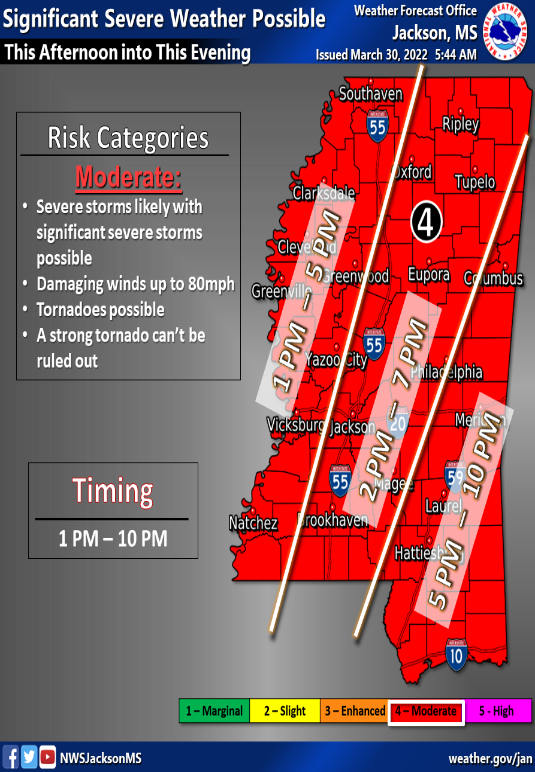
8 a.m.: Severe weather including 80 mph winds and tornadoes possible
Mississippi Emergency Management Agency officials said the entire state is at risk of severe weather with damaging winds of up to 80 mph and the potential for tornadoes.
The storm system is expected to pass through the state beginning Wednesday afternoon, with the potential for severe weather being the greatest between 1 p.m. and 5 p.m. in the western part of the state, 2 p.m. to 7 p.m. in central Mississippi and 5 p.m. to 10 p.m. in southeast Mississippi.
SEVERE WEATHER OUTLOOK: Potential for tornadoes, 80 mph winds. What to know
Shelters in Adams and Webster counties opened early Wednesday and others announced plans to open later in the day. Click here to find a shelter in your area.
No shelters have announced openings in the Jackson metro area.
Forrest and Lamar counties announced they would open shelters Wednesday afternoon:
Forrest County: 946 Sullivan Ave., Hattiesburg, 1 p.m.
Lamar County: 105 Central Industrial Row, Purvis, 2 p.m.
Area schools announced they would switch to virtual learning for the day, including those in Jackson and Madison.
About 1,000 customers were without power throughout the state as of 8:30 a.m. Wednesday, poweroutage.us reported.
Mississippi weather radar
Do you have a story to share? Contact Lici Beveridge at lbeveridge@gannett.com. Follow her on Twitter @licibev or Facebook at facebook.com/licibeveridge.
This article originally appeared on Mississippi Clarion Ledger: Mississippi weather updates: Tornados possible, high winds expected
