Live updates: Winter storm continues in Kansas City, bringing travel hazards, power outages
A strong, cross-country winter storm is expected to bring several inches of snow to the Kansas City region as the system cuts across the central part of the United States, according to the National Weather Service.
The heaviest snowfall in the region is expected to fall north of U.S. 36 near St. Joseph. Some areas of northwestern Missouri could see 6 inches to a foot of snow, according to the latest forecast.
Meanwhile, there will be a significant drop off in snowfall totals between U.S. 36 and Interstate 70. The Kansas City metro is expecting to 6 inches of snow while areas further south will see even less. Butler, Missouri, could see between a trace and 2 inches of snow.
A winter storm warning has been issued for northwestern Missouri through 6 p.m. Tuesday. Meanwhile, the Kansas City metro is under a winter weather advisory.
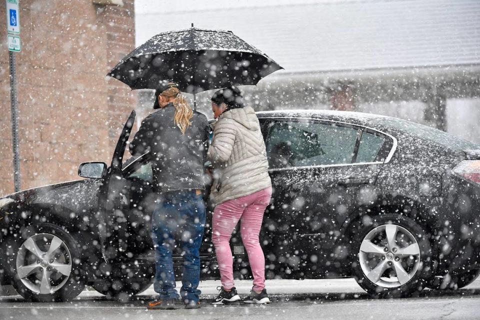
Strong winds could reduce visibility. Those who head out into the storm are urged to used caution on the roads as well as sidewalks and parking lots.
Evergy reports thousands without power
Updated 8:30 a.m.: Evergy has reported thousands of power outages so far as a winter storm coupling snow and strong winds continues to impact the Kansas City metro area Tuesday.
The utility company has reported more than 3,800 customers impacted by outages in Kansas City, and more than 4,700 customers affected in and around Raytown as of Tuesday morning.
More than 1,500 customers have been affected by outages around Sugar Creek and Independence.
In Johnson County, outages have affected more than 5,000 customers as of Tuesday morning, particularly in Mission and Overland Park, according to Evergy’s outage map.
Because of the continued storms, Evergy said customers should expect delayed restoration times in these areas.
How much snow has fallen?
Updated 8:13 a.m.: Several inches of snow has already fallen in the Kansas City area by Tuesday morning and more snow is on the way.
At Kansas City International Airport, 3.9 inches of snow fell during the last 24 hours ending at 6 a.m., according to the weather service.
Meanwhile, the National Weather Service measured 4.5 inches of snow at its office in Pleasant Hill as of 3 a.m., according to a post on X, formerly known as Twitter.
Much of the Kansas City area had between 4 and 6 inches of snowfall so far from the storm, according map of an analysis of local storm reports.
Snowfall totals are preliminary and will likely increase as another band of snow moves through.
More snow on the way
Updated 7:28 a.m.: A second swath of snow is moving into the Kansas City area and is expected to bring another 1 to 2 inches to the metro and surrounding areas, according to the National Weather Service. Some areas may see as much as 3 more inches from this band of snow.
The snow is expected to continue throughout the morning, coming to an end from west to east in the afternoon and early evening, the weather service said.
Northwest winds are expected to increase throughout the morning, reaching sustained speeds around 25 mph. Wind gusts up to 45 mph will be possible.
Patchy blowing snow from the strong winds could occasionally reduce visibility to a half mile during the day and make travel very difficult, the weather service said.
The winter storm warning for the Kansas City metro and areas to the north remains in effect until 6 p.m. Tuesday.
Several KC school districts cancel classes Tuesday
Updated: 9:50 p.m.: Kansas City Public Schools and several other districts announced a snow day for Tuesday.
The decision to call off classes entirely was also made by Independence, Kansas City, Kansas, Olathe and others across the Kansas City metro. Childcare programs and after-school activities were also being canceled in light of the weather.
Some districts were planned to have remote learning, including Raymore-Peculiar, Park Hill and Raytown.
USPS to Kansas Citians: Clear snow and ice
Updated 5:28 p.m.: The U.S. Postal Service wants Kansas Citians to help make Tuesday deliveries safer for mail carriers by shoveling snow and ice from sidewalks, stairs and near mailboxes.
Significant snow accumulation is predicted in parts of the Kansas City metro. The Postal Service says homeowners and businesses can help make deliveries faster and more efficient Tuesday by helping out with the snow.
Services may be delayed Tuesday in cases where streets and walkways are hazardous for carriers, the service says. Any curtailed deliveries Tuesday will be attempted Wednesday.
Snow emergency declared for KCK, Wyandotte County
Updated 4:21 p.m.: The Unified Government of Wyandotte County and Kansas City, Kansas, is declaring a snow emergency.
The emergency declaration begins at 10 p.m. Monday and is set to last through 5 a.m. Wednesday, according to a news release from the Unified Government. Public works crews were responding to the snowfall with treatment of roads throughout the county.
Services and programs were also to be affected by the storm.
Scheduled government meetings were canceled Monday. Delays of up to an hour were expected for public transit.
And on Tuesday, Unified Government offices and the KCK Municipal Court were to be closed to the public. The Wyandotte County District Court was also to be closed Tuesday in light of the storm.
Updated chance of snowfall exceeding certain amounts
Updated 3:40 p.m.: As snow continues to fall across the Kansas City metro and areas to the north, the National Weather Service has tweaked the chance of snow by certain amounts.
There is still some uncertainty in the amount of snow that will fall in the Kansas City area as well as long Interstate 70, according to the weather service’s latest update. Between 3 and 6 inches of snow is possible, with areas to the south expected to see much less.
Cities in northwest Missouri, from St. Joseph to the Iowa Border, are still expected to see the heaviest amounts — between 6 and 12 inches of snow.
See the updated city-by-city look at the chance of snowfall exceeding certain amounts in the Kansas City region.
Eastbound I-70 in western Kansas
Updated 2:50 p.m.: Both directions of Interstate 70 were closed Monday afternoon from Hays, Kansas to the Colorado state line, the Kansas Department of Transportation said on its travel advisory website.
Winter weather and reduced visibility was causing dangerous travel conditions.
“Many secondary roads also closed in northwest Kansas due to dangerous travel conditions,” the weather service said. “Travelers are cautioned not to drive around the road closures, barricades and gates.
Technical Trooper Tod Hileman posted a video on X that showed low visibility and icy road conditions along westbound Interstate 70 in Gove County.
“It got worse the farther I went west,” he said. “Be safe everyone.”
I -70 closed now at Hays to Colorado, east and westbound. If you were wondering why, look no further!
This is westbound I-70 in Gove County. It got worse the farther west I went. Be safe everyone. #kswx@KansasEmergency pic.twitter.com/PYCbufeo4f— Trooper Tod (@TrooperTodKHP) January 8, 2024
‘Get home safe’
Updated 2:46 p.m.: With the afternoon-evening rush hour about to get underway in Kansas City, the National Weather Service urged drivers to be careful and take their time.
“This afternoon’s commute may be extremely hazardous in some places . . . get home safe,” the weather service said Facebook.
The weather service also updated its forecast, saying there still remains some uncertainty in the amount of snowfall, including in the Kansas City area.
Between 3 to 6 inches of snow is expected for the Kansas City metro. Earlier, the weather service has issued a winter storm warning saying 4 to 7 inches of heavy snow was possible in Leavenworth, Wyandotte and Johnson in Kansas and Platte, Clay, Ray, Carroll, Chariton, Randolph and Jackson counties in Missouri.
Kansas City, as well as Leavenworth, Lansing, Overland Park, Olathe, Lenexa, Liberty, Riverside, Kearney, Independence and Kansas City, Kansas, were among the cities listed in the new warning.
Road conditions continued to deteriorate as snow continued to fall, the weather service said about 2:40 p.m. on X, formerly known as Twitter. Winds are expected to increase Monday night, leading to areas of blowing snow into Tuesday.
“It would be best to postpone travel” for drivers under the winter storm warning, the weather service said.
Road conditions
Updated 1:10 p.m.: As winter weather sweeps through the Kansas City metro area, officials are asking drivers to take care on the roads, as conditions deteriorate.
“Pay attention to weather conditions and make smart decisions regarding travel,” the Missouri State Highway Patrol said in a statement. It advised residents to stay home if possible.
For the latest on roads in your area, here are state, local and other resources to check road conditions in the Kansas City metro before you get behind the wheel.
Winter storm warning issued for KC
Updated 12:30 p.m.: The National Weather Service has issued a winter storm warning for the Kansas City area, including of Leavenworth, Wyandotte and Johnson in Kansas and Platte, Clay, Ray, Carroll, Chariton, Randolph and Jackson counties in Missouri.
The warning comes as the weather service adjusted upwards the amount of snow the Kansas City area is expected to receive from the storm.
The updated forecast indicates that Kansas City could see 4 to 7 inches of snow, along with wind gusts as high as 45 mph.
“Travel could be very difficult,” the weather service said. “Patchy blowing snow could significantly reduce visibility.”
The morning or evening commute could be impacted by the hazardous conditions, the weather service said.
Move your car
Updated 12:20 p.m.: Armour Road has been activated as an emergency snow route, North Kansas City announced Monday morning.
That means all parked vehicles must be moved from Armour Road between Fayette and Linn streets by 5 p.m. Monday.
City crews were placing mobile “Emergency Snow Route/No Parking” signs on both sides of Armour Road in that stretch Monday morning.
During a declared snow emergency, vehicles are prohibited from parking in that area on Armour.
Once the snow emergency has been deactivated, parking in that area is allowed to resume.
‘The snow has arrived!’
Updated 11:41 a.m.: Snow has started accumulating in southern Johnson County, according a post to X by the National Weather Service in Kansas City about 11:10 a.m.
“Be careful if you’re traveling west or southwest of the KC Metro area,” the weather service said.
The Olathe Police Department followed shortly afterwards, saying in a tweet, “The snow has arrived!”
The department provided a few safety reminders for those who planned to be driving the next few days. Those reminders included to drive slowly, leave plenty of room between you and the vehicle in front of you, do not use the cruise control and remember that four wheel drive doesn’t mean you can stop on slick roads.
Ten minutes later, the national weather service followed up with a posting saying there is a pronounced transition between accumulating snow and rain-snow mix on the eastern side of the Kansas City metro.
The post compared conditions shown on two traffic cameras about 4.5 miles apart.
11:20am: There is a pronounced transition between accumulating snow and rain/snow mix on the eastern side of the KC Metro. These are two traffic cams ~4.5 miles away from each other (K-7 at K-10 and K-10 at I-435). Note the difference in accumulation of #snow. #KC #Kansas #kswx pic.twitter.com/tNnParEMCg
— NWS Kansas City (@NWSKansasCity) January 8, 2024
Rain, rain-snow mix, and snow falling
Updated 10:45 a.m.: Rain, rain-snow mix and snow is now falling across the Kansas City region.
“Regardless of the type, the precipitation is here and will continue through the day and into the afternoon and evening,” the National Weather Service in Kansas City said on X, formerly known as Twitter.
The rain and rain-snow mix is expected to continue to build across portions of far eastern Kansas and western Missouri, the weather service said on Facebook. Meanwhile, all snow is occurring across northwestern Missouri.
“Expect rain and rain/snow mix to move into central and north central Missouri around noon and through the afternoon,” the weather service said. “You may have moments of all snow and a mix of snow and rain across the KC Metro area through this afternoon.”

School, organization cancellations begin
Updated 10:30 a.m.: The first snowflakes hadn’t even begin to fall, yet one school district had already canceled classes for Monday.
“Due to the forecasted inclement weather with snow/ice expected to begin tomorrow morning, there will be NO SCHOOL for USD 207 on Monday, January 8th,” the Fort Leavenworth school district announced Sunday night.
Meanwhile, the most popular question of the day as of 7:40 a.m. Monday was whether the De Soto school district would have school on Tuesday, Superintendent Corey Gibson said in a post on X, formerly known as Twitter.
“We will continue to monitor conditions and forecasts,” he said. Any changes will be shared as soon as a decision can be made.”
Greetings,
The most popular question of the day answered as of 7:40 a.m. Mon.(Jan. 8,24).We will continue to monitor conditions and forecasts. Any changes will be shared as soon as a decision can be made. (Video disclaimer: this is not how superintendents determine “snowdays” :) pic.twitter.com/vT7h6gM4z1— (@USD232super) January 8, 2024
Park Hill Schools said on X, “Yes, we are watching the weather. Happy Monday!”
An updated list of school and organization closings and delays around the metro is available here.
Where will the heaviest snow fall?
Updated 9:20 a.m.: Snowfall totals are expected to vary widely across the Kansas City region as the winter storm passes through, according to the National Weather Service.
Cities in northwest Missouri, from St. Joseph to the Iowa Border, will likely see the most snowfall. Between 6 and 12 inches of snow is possible.
Meanwhile, the Kansas City metro and areas along Interstate 70 are expected to see 3 to 6 inches. Areas further south will see much less.
See the city-by-city look at the chance of snowfall exceeding certain amounts in the Kansas City region.
Weather watches and warnings
A live data feed from the National Weather Service containing official weather warnings, watches, and advisory statements. Tap warning areas for more details. Sources: NOAA, National Weather Service, NOAA GeoPlatform and Esri.

