Updates: NWS confirms tornado in Marion County Tuesday night, sends crew to survey
Just days after a round of severe weather spawned at least nine tornadoes, Iowa found itself back in the bullseye for severe weather on Tuesday.
Much of the state was under a Level 3 (enhanced) or Level 4 (moderate) risk of severe weather Tuesday afternoon into evening. Much of the state experienced severe thunderstorms and large hail, while at least one tornado touched down near Pleasantville in Marion County.
NWS sends crews out to assess Marion County tornado
The National Weather Service based in Des Moines is sending out crews Wednesday to assess a tornado that touched down near Pleasantville in Marion County on Tuesday evening.
Donna Dubberke, a meteorologist with NWS, said the other tornado spotted on Tuesday near Malcolm in Poweshiek County has not yet been confirmed by the NWS.
"We had a funnel cloud report from there but have not confirmed that one yet," she said.
The assessment in Marion County will track the tornado's path, including where it started and ended, and also seek to assess the level of damage to the surrounding area.
While yesterday's storm did not spawn as many tornadoes as last week's, Dubberke said this most recent storm's long path all the way from southwest Iowa to northeast Iowa and the amount of hail that fell across the entire state makes it notable.
"Just looking at the map of where the reports all occurred, that is how I think people will remember the day," she said, "mostly as for all of the hail that fell."
Storms near the Quad Cities on Tuesday morning produced hail up to 4 inches in diameter, and later in the day up to 3 inch hail was reported in Osceola, Dubberke said.
Dubberke said looking ahead, Iowa's peak tornado season in May is quickly approaching.
"We don't really have an indication of how any particular severe weather season will play out," she said. "... For right now, it's sort of a typical severe weather season I would say. We've had a couple of tornado events so far and we're just getting into the peak of our severe weather season. So staying ready is always a good idea this time of year."
More: How to claim tornado relief in Iowa if your house or property has been damaged
Des Moines sees last of Tuesday's storm
As of 10:20 p.m., Des Moines will no longer need to brace for heavy storms. Those storms with hail and gusty winds are moving past the metro toward eastern Iowa heading into the late hours of Tuesday night, according to the National Weather Service's updated radar.
10:20PM Radar Update: A line of storms is pushing east with hail and winds being the primary threats. The Des Moines metro has seen the last round of storms for the night. #iawx pic.twitter.com/QcAZmA5tbV
— NWS Des Moines (@NWSDesMoines) April 5, 2023
Storms in eastern Iowa expected midnight through 6 a.m.
The National Weather Service out of the Quad Cities warned another round of storms will likely hit the area in eastern Iowa between midnight and 6 a.m. The storms are traveling west and could include large hail and potentially damaging winds. One or two tornadoes are also possible, NWS warned.
PLEASE SHARE! Severe storms are still expected through the night. The main threats are large hail and damaging winds. A tornado or two are still possible. #IAWX #ILWX #MOWX pic.twitter.com/bbNrZfNlge
— NWS Quad Cities (@NWSQuadCities) April 5, 2023
Des Moines police report pea-sized hail
A severe thunderstorm warning issued for Des Moines has been extended until 9:30 p.m., according to the National Weather Service. It could produce golf-ball size hail.
The Des Moines Police Department tweeted that officers are reporting pea-sized hail on the city's west side. Hail ranging from pea-sized to quarter-sized has been reported in the city since storms began late Tuesday.
A report of 1-inch hail in northeast Des Moines was submitted to the NWS at about 8 p.m.
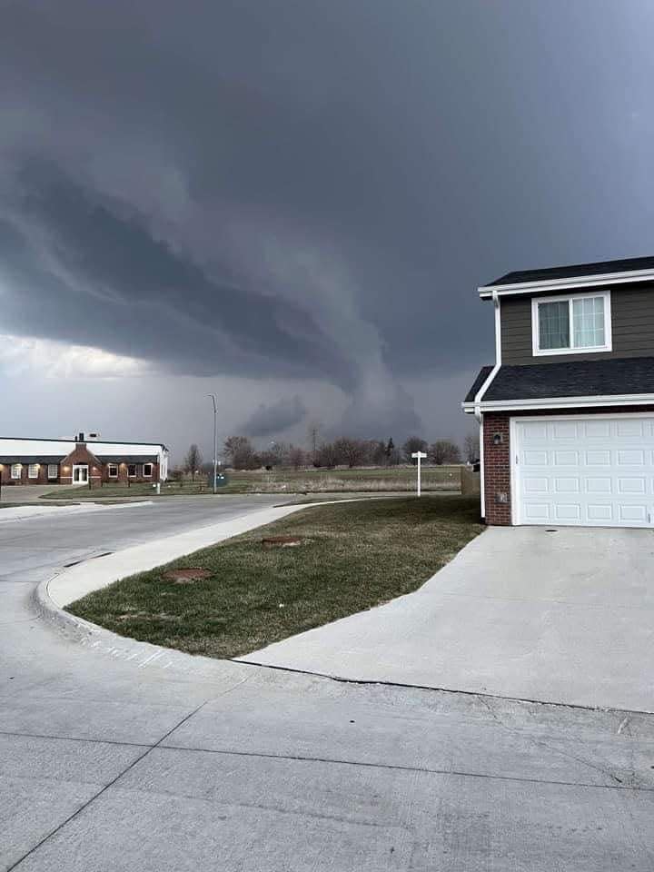
Storm chaser catches tornado near Knoxville
Trained storm spotter Clarence Smith captured video of a tornado as it moved through Marion County on Tuesday evening. The tornado was confirmed just before 7 p.m.
Final two minutes of the tornado near Knoxville, IA earlier this evening. #iawx pic.twitter.com/oQGpRc9dRe
— Clarence Smith (@clarencewlsmith) April 5, 2023
Possible tornado reported near Malcom
The National Weather Service observed a possible tornado at 7:54 p.m. in Poweshiek County near Malcom, about 6 miles north of Montezuma, traveling northeast at 50 mph.
A tornado warning is in effect in Poweshiek and Tama counties, including Brooklyn, Malcom and Hartwick, until 8:30 p.m. Quarter-sized hail is possible.
Tornado Warning including Brooklyn IA, Malcom IA and Hartwick IA until 8:30 PM CDT pic.twitter.com/EZL9CxUd88
— NWS Des Moines (@NWSDesMoines) April 5, 2023
Debris reported near Milo
After a tornado touched down near Pleasantville on Tuesday just before 7 p.m., spotters confirmed it left behind debris in southeast Milo. The extent of the damage is unknown.
Tornado confirmed near Pleasantville in Marion County
The National Weather Service issued a tornado warning at about 6:50 p.m. in the region including Pella, Knoxville and Monroe that expires at 7:30 p.m.
A confirmed tornado was located near Pleasantville, or 8 miles west of Knoxville, moving northeast at 55 mph at 6:58 p.m., according to the NWS. Weather spotters confirmed the sighting.
Tornado. West of Knoxville, IA. 7:07PM PK457 #tornado #iawx @NWSDesMoines pic.twitter.com/uJo8mqmREB
— Clarence Smith (@clarencewlsmith) April 5, 2023
Other locations in the path of this tornadic thunderstorm included Lake Red Rock, Elk Rock State Park, Monroe, Pella Municipal Airport, Pella, Reasnor and Sully.
The region could see up to ping pong-sized hail.
Tornado Warning including Pella IA, Knoxville IA and Monroe IA until 7:30 PM CDT pic.twitter.com/iHDL6G4I3n
— NWS Des Moines (@NWSDesMoines) April 4, 2023
See the NWS weather radar as storms move over Des Moines

As dark clouds move over Des Moines, areas south and west of the city are starting to see up to quarter-sized hail.
The National Weather Service reported between 5:40 and 5:54 p.m., 0.75-inch-sized hail fell in Earlham, just southwest of the city, while up to one-inch-sized hail fell in Boone.
Here's the NWS weather radar showing the storms trajectory as it moves over Des Moines:
6PM Radar Update: Storms have continued to form in central Iowa this evening. Large hail reports have been common with the storms to the west and south of Des Moines. #iawx pic.twitter.com/9GfkbiKzwv
— NWS Des Moines (@NWSDesMoines) April 4, 2023
Tornado watch in Des Moines, Iowa City, Ames central and eastern Iowa for Tuesday evening
A tornado watch has been issued for parts of Illinois, Iowa and Missouri until 10 PM CDT pic.twitter.com/lWCROHIIT8
— NWS Des Moines (@NWSDesMoines) April 4, 2023
A tornado watch has been issued until 10 p.m. for much of central and eastern Iowa. The watch area extends from west of the Des Moines metro area through the eastern border of the state, roughly south of U.S. Highway 20.
Forecasters with the National Weather Service believe supercell thunderstorms will develop across the state by 5 p.m. Several tornadoes, some of which could be strong, are likely in this area, along with wind gusts of up to 70 mph and softball-sized hail. Powerful straight-line winds also are possible.
More: What is a tornado watch? Tornado warning? Here's a look at the differences
What are the risks of today's potential storms?
National Weather Service models shows the storm is likely to develop along the west of Interstate 35 and will impact regions in central and eastern Iowa, including Des Moines, Cedar Rapids and the Quad Cities. The tornado-friendly weather originating out of southwestern Iowa is likely to spur a squall line, resulting in very powerful straight-line winds with the possibility of tornados and hail, the NWS said.
It estimates there is a 15% to 29% chance of tornadoes in the region, some of which could reach the level of EF2 or greater.
There also is a 30% to 44% chance that the region could experience at least quarter-sized hail, with some hail estimated to be the size of a baseball. There's also greater than a 30% chance winds reach above 58 mph, with some gusts nearing or exceeding 80 mph.
Another squall line is possible around midnight or later in the southeast Iowa counties, the NWS said.
Here's the latest SPC outlook and severe weather probabilities for tonight.
Highest risk from SW to Central to Eastern IA.
Tornadoes, large hail, damaging winds all possible.
Storms expected to move rapidly. Have a plan and be ready to take action if needed! #iawx pic.twitter.com/e8v31zb6Qg— NWS Des Moines (@NWSDesMoines) April 4, 2023
What is the forecast for Iowa today?
The NWS expects widespread severe thunderstorms across Iowa on Tuesday. The highest risk starts in central Iowa around 4 p.m. and continues until 11 p.m. Eastern Iowa will see a round of storms earlier on Tuesday and a second round, with a stronger severe risk, from about 6 p.m. to midnight.
Storms are expected to move quickly, at up to 45 mph.
In Des Moines, temperatures are expected to reach near 80 degrees this afternoon. Overnight, lows will drop to around 40 degrees.
How to prepare for a possible tornado
Before a tornado strikes, make sure that you have a safety plan, including multiple ways to receive weather alerts.
The weather service says it's always important to have an emergency plan in place in the event of severe weather, including designating a "safe place" in your home, preferably away from windows and in an interior room. Keeping supplies handy like flashlights, batteries, food, water, clothes and shoes is also recommended.
More: Tornado safety: What to do when a watch or warning is issued depends on where you are
This article originally appeared on Des Moines Register: Iowa tornado: NWS confirms one tornado Tuesday night in Marion County

