Live weather updates: Flash flood emergency in Broward. Officials urge to stay inside
We’ll have live updates through the day on the bad weather in South Florida. Here’s what to know:
Chances of rain in South Florida lessen in coming days
9 p.m.: After a deluge of rain causing mass flooding all over South Florida on Wednesday, the National Weather Service in Miami is predicting rain chances will lessen in the coming days.
Thursday’s forecast expects to see a 50% chance of rain, with potential for flooding, dropping to 30% by Thursday night. Rain chances will hold there through Friday and then a sunny day is predicted on Saturday.
However, Sunday will return the over-soaked region to a 30% chance of rain.
READ MORE: South Florida has seen three days of intense rain and flooding. When will it finally end?
Brightline halts trains due to weather
8:50 p.m.: Brightline high-speed trains between Miami and Fort Lauderdale have been suspended, the company tweeted. It is unclear when service will resume again. Fort Lauderdale, especially Fort Lauderdale-Hollywood International Airport, is seeing extreme flooding.
FLL airport has also shutdown all services due to weather.
Fort Lauderdale Airport (pics from a friend of a friend) @NWSMiami pic.twitter.com/qnqGHs0EWh
— Brooke Silverang (@WPBF_BROOKE) April 13, 2023
Flash flood emergency issued for parts of Broward
8:20 p.m.: The National Weather Service in Miami issued a flash flood emergency for Broward cities until 11 p.m. A higher level alert than a warning, forecaster say the emergency is considered a life-threatening situation.
The cities affected include Fort Lauderdale, Sunrise, Lauderhill, Hollywood and Dania Beach. Residents in and near those cities are advised to immediately move to elevated ground.
A flash flood EMERGENCY is in effect for areas near Hollywood, Dania Beach, and Fort Lauderdale. This is a life threatening situation. https://t.co/gJWhKmGsnq
— NWS Miami (@NWSMiami) April 13, 2023
The Fort Lauderdale Fire Department is urging motorists to stay off the road and for residents not to leave their homes unless absolutely necessary.
Broward fire station floods, firefighters evacuate
6:50 p.m.: Broward Sheriff Fire Rescue Station 32 was evacuated as heavy flooding in the area seeped into the building. Firefighters and other personnel at the Fort Lauderdale station are being moved to other locations, Fire Rescue Battalion Chief Michael Kane said.
There will be no impact to emergency and non-emergency call response times, he added.
Broward flash flood warning extended
6:30 p.m.: The flash flood warning issued for parts of Broward has been extended to 9:30 p.m. The cities affected include Fort Lauderdale, Hollywood and Sunrise.
Flash Flood Warning including Fort Lauderdale FL, Hollywood FL and Sunrise FL until 9:30 PM EDT pic.twitter.com/WcsjuhBRbX
— NWS Miami (@NWSMiami) April 12, 2023
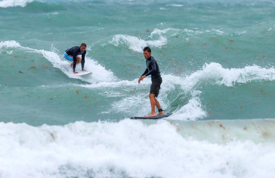
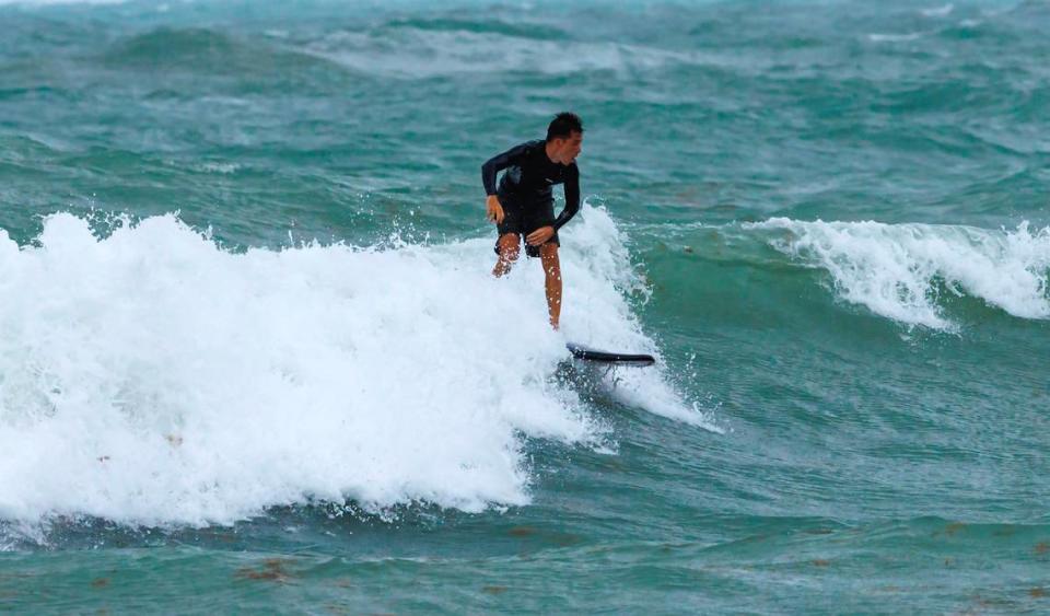
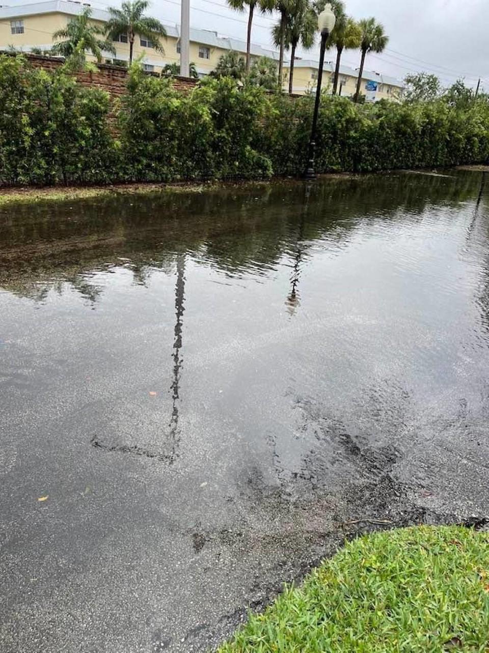
Photos: Sunny Isles Beach doused in heavy rains, but surfers see opportunity
6:20 p.m.: Pictures from the streets of Sunny Isles Beach show stranded cars in knee-deep water as the coastal city receives the same weather treatment much of South Florida saw Wednesday.

However, surfers took advantage of the waves at the Bal Harbour Lighthouse while a rip current risk remained in effect until Thursday evening.
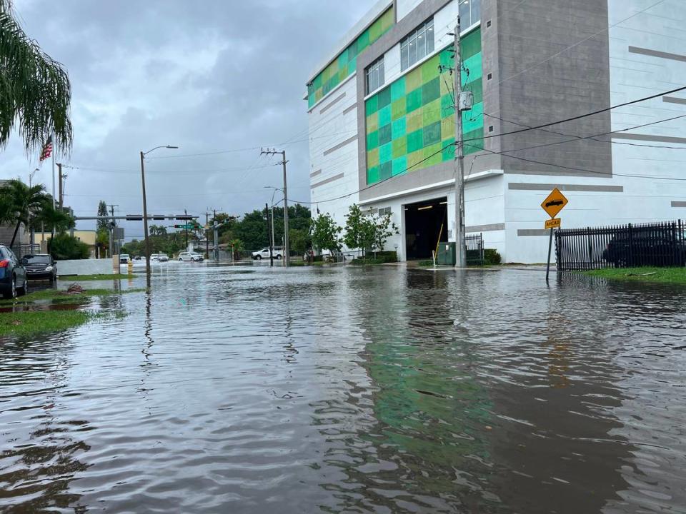
City of Miami works to reduce flooding
6:10 p.m.: In response to the flooding, the city of Miami installed temporary stormwater pumps at these seven locations: Mary Brickell Village, Northeast 23rd Street, North Bayhomes Drive, Northeast 13th Street and North Bayshore Drive, Northeast 18th Street and North Bayshore Drive, Morningside, and Northwest 32nd Street and 21st Avenue.
Several social media posts and Miami Herald reporters have described streets flooded with knee-deep water causing traffic delays and impassable areas. Miami is currently under a flash flood warning until 7:45 p.m.
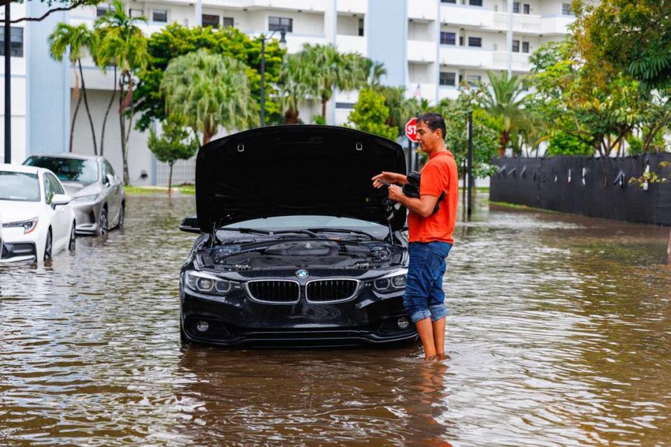
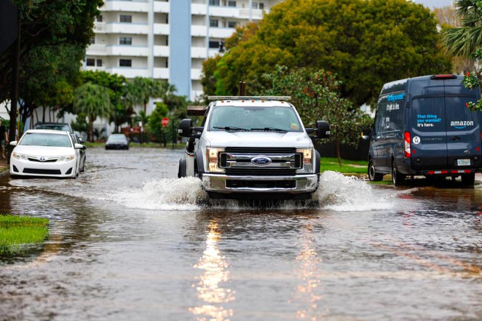
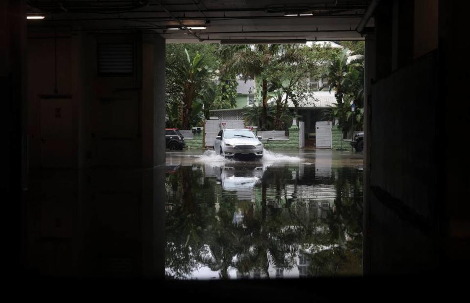
Photos: Rain floods Miami-Dade, Broward streets
6 p.m.: Photos and video posted to social media show flooded streets and heavy rain in Miami-Dade and Broward. Here’s what the roads-turned-murky rivers looked like:
READ MORE: Rain is falling and streets are flooding in Miami. See for yourself what it looks like
Weather causes Broward road closures
5:50 p.m. Rush hour traffic and weather conditions have forced the closure of the Henry E. Kinney Tunnel in Fort Lauderdale. The downtown area is also seeing issues for the same reasons.
So much rain in fowntown Fort Lauderdale. We got a swimmer at rush hour on Broward Boulevard @wsvn @nbc6 @SunSentinel @WPLGLocal10 @Susannah_Bryan pic.twitter.com/RXg67i3yrt
— Adam Horowitz (@AHorowitzLaw) April 12, 2023
Flash flooding, strong winds may hit parts of Miami-Dade, Broward
5 p.m.: The National Weather Service issued a flash flood warning and a special weather statement for several Miami-Dade cities.
Under the special weather statement, the NWS says much of west Miami-Dade will see up to 40 mph winds until 5:15 p.m. Cities include Hialeah, Kendall, Sweetwater and Coral Gables.
The flash flood warning is in effect until 7:45 p.m. and includes Kendall, Miami, Coral Gables and Miami Springs. Forecasters advise to move immediately to higher ground and avoid walking or driving through flood waters.
A flash flood warning was also issued for Broward until 6:45 p.m. Cities include Pembroke Pines, Hollywood and Miramar. Fort Lauderdale, Sunrise and Lauderhill are under a flash flood warning until 8:15 p.m.
Flash Flood Warning including Miami FL, Kendall FL and Coral Gables FL until 7:45 PM EDT pic.twitter.com/UIj18uW68u
— NWS Miami (@NWSMiami) April 12, 2023
Fort Lauderdale Airport halts flights
4:30 p.m.: Arriving and departing flights at Fort Lauderdale-Hollywood International Airport have been temporarily halted due to heavy rain and windy conditions, the airport said on Twitter. Flights will resume when weather improves.
Travel #alert: Due to heavy #rain and windy conditions over the #FLL airport, arriving and departing flight activity has been temporarily halted until the weather improves to resume safe operations. Please check with your airline for the most up-to-date flight status. #Besafe
— Fort Lauderdale-Hollywood Int'l Airport (FLL) (@FLLFlyer) April 12, 2023
READ MORE: Fort Lauderdale-Hollywood International Airport halts all flights due to severe weather
South Florida sees several inches of rain, NWS estimates
4 p.m.: Early estimates from the National Weather Service’s Miami office suggest South Florida saw six inches of rain in two days, and it’s still coming down and adding up. The highest total was 6.35 inches in Cutler Ridge, with the western edge of Miami second at 5.91 inches.
South Broward saw a maximum of 5.20 inches in Pembroke Pines and 4.93 inches in Davie.
READ MORE: Rainfall estimates are in as a rainy week continues to flood South Florida cities
Flash flood warning
3:40 p.m.: Several cities in central Broward are under a flash flood warning issued by the National Weather Service in Miami Wednesday afternoon. The warning runs to 6:45 p.m. Cities include Fort Lauderdale, Hollywood, Davie, Plantation, Sunrise, Lauderhill and Dania Beach.
READ MORE: Weather alert: Flash flood warning issued for parts of Miami-Dade and Broward
Miami streets turn into rivers as rain comes down
3:30 p.m.: Persistent rainfall turned streets into murky rivers in one of the city of Miami’s most flood-prone neighborhoods, Shorecrest, near Biscayne Bay. Knee-deep water on Northeast 10th Avenue isn’t stopping drivers, like a USPS delivery truck.
Surfside is also seeing streets filled with rainwater with residents and cars wading through.
Now Surfside @wsvn @fox_sheldon @OfficialJoelF pic.twitter.com/IllkIw8Vbe
— Super Cars Miami Beach (@supercarsmb) April 12, 2023
Tornado warning for parts of Broward, Miami-Dade
3:05 p.m.: The National Weather Service in Miami announced several Broward and Miami-Dade areas are under a tornado warning until 4 p.m. Pea-sized hail could also be seen. Cities under the warning include Davie, Pembroke Pines, Hollywood, Hallandale Beach and north unincorporated Miami-Dade.
Tornado Warning continues for Hollywood FL and Dania Beach FL until 4:00 PM EDT pic.twitter.com/7rkqye9utN
— NWS Miami (@NWSMiami) April 12, 2023
Funnel cloud possibility
12:52: National Weather Service issued a special weather statement concerning a strong thunderstorm threatening portions of southern Broward County through 1:15 p.m.
▪ Meteorologists tracked a strong thunderstorm capable of producing a funnel cloud over West Park, near Hollywood, moving northwest at 15 mph. Funnel clouds and winds in excess of 40 mph are the primary threats.
▪ Locations in the warning area include: Fort Lauderdale, Pembroke Pines, Hollywood, Miramar, Pompano Beach, Davie, Plantation, Sunrise, Tamarac, Margate, Hallandale, Miami Gardens, Lauderhill, Weston, Coconut Creek, North Miami Beach, Oakland Park, North Lauderdale, Aventura and Lauderdale Lakes.
A special weather statement has been issued for Fort Lauderdale FL, Pembroke Pines FL and Hollywood FL until 1:15 PM EDT pic.twitter.com/0WSnTZDZcT
— NWS Miami (@NWSMiami) April 12, 2023
Street flood advisory
12:35 p.m.: The National Weather Service in Miami issued a street flood advisory through 2 p.m. after one to two inches of rainfall from thunderstorms moving through Miami-Dade and Broward counties. Some one to three inches more are expected over the areas in the next hour or two as the storms head north.
“This additional rain will result in minor flooding. If the rainfall amounts increase more than forecast, then a flash flood warning may be needed for this area,” the weather service said.
Here are some of the areas that may see flooding.
Miami-Dade: Miami, Hialeah, Miami Beach, Surfside, Miami Gardens, North Miami, Doral, North Miami Beach, Aventura, Miami Lakes, Hialeah Gardens and Sunny Isles Beach.
Broward: Pembroke Pines, Hollywood, Miramar, Davie, Hallandale, Weston, Dania Beach and Cooper City.
Rain is persisting over parts of Northern Miami Dade County & SE Broward. Because of this @NWSMiami has issued a Street Flood Advisory for the potential of ponding of water on roadways in shaded area. If you must drive here, please remain alert and use caution. pic.twitter.com/ZXX53OwxFw
— Phil Ferro (@PhilFerro7) April 12, 2023
Traffic issues
1 p.m.: Heavy flooding on Northeast 191st Street in Aventura has forced a temporary road closure, Aventura police posted on Twitter. Police suggest alternate routes until the water clears.
#AventuraPolice ***TRAFFIC ALERT*** Heavy flooding on 191st has required a temporary road closure. Use alternate routes until further notice. Thank you. @cityofaventura pic.twitter.com/OLCINkvoUI
— Aventura Police (@aventurapolice) April 12, 2023
12:30 p.m.: The weather service reports that the intersection of Northwest 167th Street and Sixth Avenue has standing water on the roadway.
10:30 a.m.: Not surprisingly, rain-soaked roads mean slowdowns (and worse). Miami Herald reporter Grethel Aguila was heading north on Interstate 95 this morning and reports that stretches were completely backed up, especially near Opa-locka and the Miami Gardens area.
Updated: Planned construction in Broward County on University Drive South, beyond Broward Blvd. Right lane blocked. Last updated at 10:00 AM. https://t.co/j49dEeMovv
— FL511 Southeast (@fl511_southeast) April 12, 2023
The National Weather Service has issued a Flood Watch through 8PM Wednesday for Miami-Dade County. The Division of Emergency Management will continue to monitor this watch and update as needed. Please exercise caution while navigating through the streets of Miami. pic.twitter.com/OISHGBdlm2
— Miami Fire Rescue (@CityofMiamiFire) April 11, 2023
Keys marine warning
9:40 a.m.: The National Weather Service in Key West issued a marine warning for Gulf waters from East Cape Sable to Chokoloskee, 20 to 60 nautical miles out and Gulf of Mexico from West End of Seven Mile Bridge to Halfmoon Shoal until 10:15 a.m. Wednesday.
Special Marine Warning including the Gulf waters from East Cape Sable to Chokoloskee 20 to 60 NM out and beyond 5 fathoms and Gulf of Mexico from West End of Seven Mile Bridge to Halfmoon Shoal out to 5 Fathoms until 10:15 AM EDT pic.twitter.com/sqx9ptjT1k
— NWS Key West (@NWSKeyWest) April 12, 2023
What we’re saying about the rain
9:35 a.m.: “Here in Coral Gables, water continues to fall out of the sky and land all over the ground.”
— Dave Barry, on the scene.

9 a.m.: Wednesday will be a day fit for a frog.
“Weary of the weather? We’re not done yet,” says CBS News Miami meteorologist Lissette Gonzalez.
Get ready for a WET WEDNESDAY ahead! Keep your umbrella close. Scattered showers are soaking much of #SouthFlorida now Throughout the day heavy downpours will lead to more flooding. Stay with @CBSMiami for updates #CBSMiami pic.twitter.com/XuwxvKPGSq
— Lissette Gonzalez (@LissetteCBS4) April 12, 2023
The National Weather Service in Miami’s flood watch remains in effect through Wednesday evening for coastal Miami-Dade, Broward and Palm Beach.
“This amount of rain on already saturated soils from recent rainfall may result in flooding conditions, especially for poor drainage locations,” the service warns.
That frog caught in a weather service rain gauge even looks weary of the wetness.
2.72" and a friend.
That was the 24-hour rainfall at our office, with a 2-day total of 5.17".
Additional rounds of heavy rain are possible today, with Flood Watches remaining in effect for Metro/Coastal areas of Broward and Miami-Dade Counties through this evening. #flwx pic.twitter.com/HVKsKZ4FSb— NWS Miami (@NWSMiami) April 12, 2023
READ MORE: The rains and floods come and go in Florida. What’s left behind can ruin homes and lives
Rain in inches
8:45 a.m.: The weather service office on the Florida International University campus in Miami-Dade’s Tamiami neighborhood notched 2.74 inches of rain in a 24-hour period Tuesday, for a two-day total of 5.17 inches, meteorologists posted on Wednesday morning.
CBS News Miami meteorologist Lissette Gonzalez said Miami-Dade could see three to five inches of rain from 9 a.m. to 8 p.m. Broward could see two to four inches from 10 a.m. to 8 p.m. The Florida Keys could get an additional three inches of rain.
Miami-Dade could see three to five inches of rain from 9 a.m. through 8 p.m. Broward could see two to four inches of rain from 10 a.m. to 8 p.m. The Florida Keys could get an additional three inches of rain through 9 a.m. https://t.co/tcqsUwxvgu @LissetteCBS4
— CBS News Miami (@CBSMiami) April 12, 2023
When will the flood threat loom largest? Current forecast timing for the heaviest rain is late Wednesday morning into the late afternoon hours, the weather service said. Fueling the situation: numerous showers and thunderstorms developing out of a warm front.
4/12 @ 9:00am - Flood threat continues to increase across Miami-Dade and Broward counties this morning as numerous showers and thunderstorms develop out ahead of a warm front. Current forecast timing for the heaviest rain is late this morning into the late afternoon hours. #flwx pic.twitter.com/pYD13P8oBD
— NWS Miami (@NWSMiami) April 12, 2023
When will the rain end?
Today will likely be the wettest day of the week! Hang in there. We should see improvement by Friday and this weekend. @CBSMiami #CBS4 pic.twitter.com/DYbqtrBrAS
— Lissette Gonzalez (@LissetteCBS4) April 12, 2023
8:30 a.m.: Wednesday and Thursday may well be wetter than the earlier part of the week. And Miami-Dade County is urging residents to prepare for more rain and flooding as it works to protect critical infrastructure. Friday and Saturday should be clear. But then there may be more rain on the way. Read the forecast ahead here.
Do you have photos or videos of weather happening in your neighborhood? Send them to hcohen@miamiherald.com and we may post some on this live updates feature.

