Love hiking? See the top 6 spots in New York with the best trails
New York is a paradise for outdoor enthusiasts, with its diverse landscapes and stunning natural beauty. From enchanting waterfalls to majestic mountains, the Empire State offers a wide array of hiking trails for adventurers of all levels.
If you're ready to explore the great outdoors, here are the six best hiking trails in New York that should be on your bucket list, according to GORP – the Great Outdoor Recreation Pages – which is is one of the longest-standing outdoors-focused websites, established in the late '90s. It focuses on outdoor activities, destinations, gear and how-to guides for everything from camping to hiking to fishing and paddling.
"The popularity of hiking has exploded since 2020, and that means more people are trying to branch out and find new hiking areas," said GORP's editor, Alan Greenfield. "We tried to include the outstanding hiking trails of New York, while realizing that not everyone has the same hiking objectives. Variety is important."
Watkins Glen State Park
Level: Easy, short
Dark and damp, a cavernous trail leads hikers through a 400-foot-deep gorge along Glen Creek, Watkins Glen is the oldest state park in the Finger Lakes. A walk along a stone pathway, through chiseled tunnels, spiraled steps and stone bridges transports visitors into the unmistakable landscape, a world of natural stone, flowing water and misty spray. The park is best known for its most popular attraction, the Gorge Trail, which is about 1.5 miles long and spans the length of the park. The gorge follows the path of Glen Creek at the base of the 400-foot-deep gorge and features 832 stone steps. On the trail, you'll walk under two waterfalls: Cavern Cascade and the iconic Rainbow Falls.
The 1.1-mile-long Indian trail (also called the North Rim trail) is a gently sloping path that follows the north side of the gorge. At several spots you can see the gorge below, with partial views of Rainbow and Central Cascade, the park's tallest waterfall at 60 feet. There is also a suspension bridge 85 feet above the creek that connects to the South Rim trail, which is part of the Finger Lakes Trail.
In 2015, the park placed third in a nationwide USA Today contest, a Readers' Choice award for Best State Park. Nearby Letchworth State Park won top honors.
Overlook Mountain
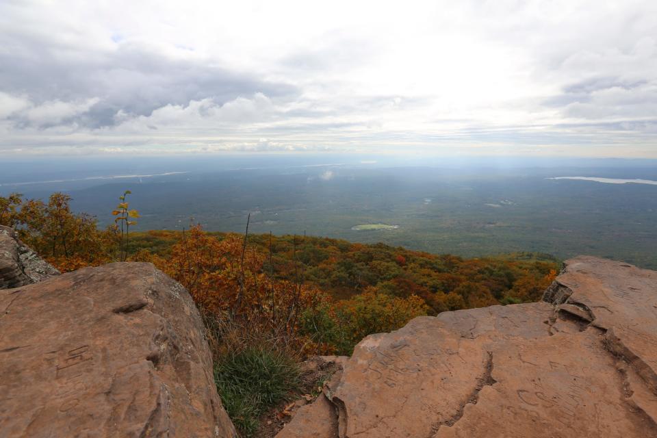
Level: Moderate, with an incline
The 4.8-mile trail to Overlook Mountain takes you to the remains of an old hotel that was once part of a resort getaway. Located near Woodstock in Ulster County, the out-and-back trail is actually an old gravel road that is a steady incline up the mountain rather than the typical forested path you'd expect to find on a mountainside.
An old fire tower that you can climb on the route. At the top of Overlook Mountain, you'll see spectacular views of the Catskill Mountains. The hike to Overlook Mountain might better be described as a walk, because there are electric power lines running the entire length of the old gravel road that makes up the trail. You will find that the trip down the trail to be pretty easy, but the experiences, the views, and the memories you’ll make while on the trail will be one of a kind.
Saranac Lake
Level: Ranging from easy to difficult, short to longer
Covering 31 miles, Saranac Lake is home to six mountains – the Baker, the St. Regis, the Scarface, the Ampersand, the Haystack and the McKenzie. Those who climb all six of these mountains (all between 3,000 and 4,000 vertical feet) are known as ‘Saranac Lake sixers.’
Baker Mountain is the easiest of the six to climb, with a two-mile stretch and a 900 foot climb on relatively gradual footing. On the other end, the Ampersand Mountain trail is about 5.5 miles, and closer to 1,800 feet of incline. The lake view from the top breathtaking. Hiking in Saranac Lake offers trails that range from family-friendly to challenging, from winding your way through pine-scented forests to walking past sparking brooks.
Saranac Lake is located in the middle of Adirondack Park and is also an excellent fishing lake.
Mount Marcy
Level: Challenging, longer
Mount Marcy boasts nearly 15 miles of trails on varied terrain and is located in Keene, Essex County, which is at the very heart of what is known as the Adirondack High Peaks.
The tallest mountain in New York at 5,343 feet, it has four different trails to hike to the summit and by many is considered a challenging hike that should be attempted only by experienced hikers. The shortest trail – the Hoevenberg Trail – is also the most popular and heavily used and is 7.4 miles one way. The Johns Brook Trail is 9 miles and begins from the garden parking on the north side of the mountain in Keene Valley. There are steeper paths closer to Marcy's summit.
The summit's massive rock dome boasts some of the best views in the Northeast. Here, you can see summits of 43 high peaks throughout the Adirondacks. On a clear day hikers can see Mount Royal in Montreal, which is nearly 65 miles north of Marcy. Be sure to tread lightly, though, as Marcy is home to endangered alpine vegetation. Walk only on designated paths and stay on open rock.
Cascade and Porter Mountains
Level: Moderately difficult to strenuous, not terribly long
The 5.6-mile out-and-back trail, located near Lake Placid, is incredibly popular.
Out of the 46 mountains in the Adirondacks, Cascade and Porter are among the easiest mountains to hike up, so expect others on the trail, especially between May and October. Despite the crowds, the trek to the summit is worth the trip. The trail, with a 2,300-foot incline, has a unique view of a waterfall and some unparalleled fly fishing. Once at the summit of Cascade, it is only another mile to reach Porter's summit. It's rather easy to climb both mountains in a single hiking outing.
Be sure to check weather conditions before hitting the trails because weather changes and intense cold conditions occur frequently in this area. It is often muddy in the spring. Winter hikers should bring snowshoes and traction/spikes to maneuver the path on snow and ice.
Finger Lakes Trail
Level: Easy and long for thru-hikers
The Finger Lakes Trail is a 1,000-mile trail system that spans New York, starting at Allegheny State Park and extending to the Catskill Forest Preserve. The main trail is about 850 miles with several spur trails, including to Niagara Falls, Bristol Hills and Letchworth State Park. The trail is almost equally on private and public land, including through existing state parks and forests.
Thru-hikers can camp along the trail, typically at primitive, designated campsites. The trail, mostly a flat footpath, also overlaps with the North Country Trail, which leads hikers from Pennsylvania through the Empire State to the Adirondack Park.
For folks who are looking for day hikes or multi-day treks, the FLT is a great destination. You will want solid maps and navigation, as the length of the trail and its many spurs and connections can make it easy to get off course.
This article originally appeared on Rochester Democrat and Chronicle: Love hiking? See the top 6 spots in New York with the best trails

