Low mountain snow totals draw concern over what's ahead for Montana summer
The weather midway through 2023-24 winter has been divided into two narratives. East of a line that bisects North Dakota’s Red River Valley temperatures through January and February have been abnormally warm, averaging nine- to 11-degrees above average. West of that line across the Dakotas and Montana it's been cold, driven largely by a mid-January arctic air breakout that dropped temperatures to 30 and 40 degrees below zero.
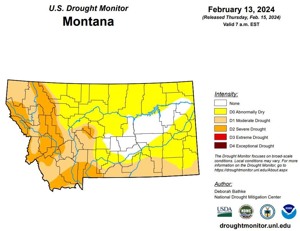
What unites these two halves is the lack of snowpack. From Montana’s continental divide on east across the Great Lakes, the region’s snowpack is critically low, leaving climatologists concerned over implications for the summer ahead.
On Thursday the National Oceanic and Atmospheric Administration (NOAA) held its monthly Climate and Drought Summary and Outlook for the North Central United States including Montana. At that presentation Kanas State Climatologist Matt Stittel highlighted both the differences and the similarities of the two regions.
“For Minnesota, Wisconsin, and Michigan; they’ve all experienced their warmest December and January on record running 9 to 11 degrees above normal,” Stittel pointed out. “Wisconsin experienced its 10th warmest January on record, and Minnesota its 11th warmest with records going back to 1895. As it stands now, these three states have a very good chance of setting records for their all-time warmest climatic winter – December, January, and February.”
Contrast that with what happened further west. Across the Dakotas, Montana, and Wyoming January’s temperatures were a bear. Overnight lows in some areas averaged 25-degrees below average due in large part to the river of arctic air that flooded the region in mid-January.
“There were dozens of new record lows for the month of January that were set during this arctic outbreak (Jan. 12 – Jan. 19)," said Stittel. “Two of these were cold enough to set all-time station records. At Dillion, Montana, it was -47 degrees, and Limon Colorado it was -30. The coldest reading that I could find from this arctic outbreak was a bone chilling -54 degrees. That was in Chester, Montana, on January 13.”
What unites the region is how dry it’s been. While the Great Falls area has been blessed by 1.57 inches of precipitation this far in February, it does not make up for the 0.26 inches it received for the entire month of January. The snowpack deficit is as critical in the upper Great Lakes area as it is in the northern Rocky Mountains.
“Parts of the upper peninsula of Michigan are 60 inches to 80 inches below normal in terms of snowfall,” Stittel said. “And there’s very little to no ice on the Great Lakes entirely. Overall, the amount of Great Lakes ice is only 4% of the total area. Lake Erie is completely ice free right now, 0%. Normally at this time of the year 40% of the Great Lakes should be covered in ice. These are all record low minimums.”
The Rocky Mountain west faces an equal snow deficit. No drainage basin in Montana currently holds as much as ¾ of the snow/water equivalent it does in an average year. The best current situation is in northwest Montana’s Kootenai Basin where the snowpack currently holds just 73% of the water it normally would midway through February. The mountains above the Missouri River basin currently carry less than 70% of the water they would in an average year, and it only gets worse as you move north. The Sun/Teton/Marias River basins are all below half of their water retention average.
“Montana really stands out here because those percentages are running from 46% to 67% of normal,” Stittel said. “The Teton Pass Ski Resort (northeast of Great Falls) announced recently that they were going to close for the season because there simply isn’t any snow. They were only open for four days this winter. The gentleman who owns the resort said they have the lowest levels at the ski resort in the last 55 years.”
“Right now, in the area above Fort Peck the current snowpack is only at 64% of normal. So right now, we are running below 2015. That was the year in which the maximum snow water was only around 12 inches. It is concerning now that we are running as far below as we are. There’s certainly time to increase those totals, but if we don’t have any more snow any time soon this is going to be very important. We certainly need all the snow we can get.”
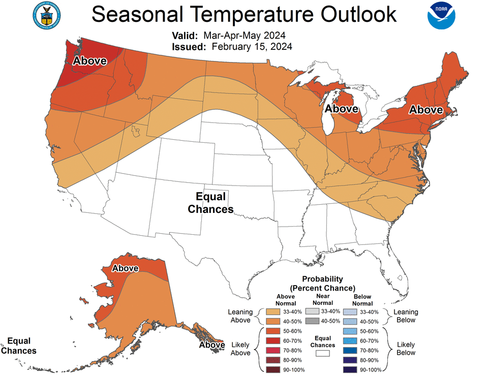
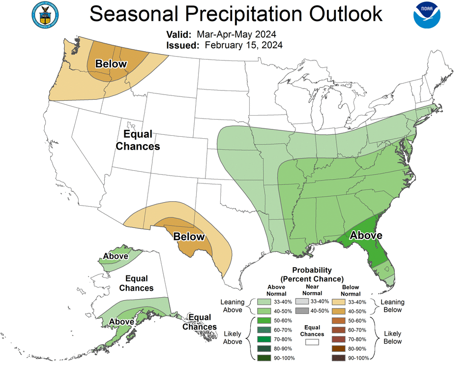
So, what does this mean for the spring and summer ahead? Climatologists expect that warm and dry conditions will continue throughout spring but may well change, as global weather conditions over the east-central Pacific morph during the summer.
“We’d certainly like to see more moisture in western Montana over the next few weeks, but we don’t see it at this point,” said Stittel. “Above normal temperatures are forecast pretty much everywhere with the exception of far western Montana. The probability of Minnesota, Wisconsin, and Michigan setting their all-time warmest winter records looka really good. The probability for a warmer than average April and May is also likely for Montana and other midwestern states along the Canadian border. Unfortunately for northwest Montana, below normal precipitation is probable there.”
However, the El Nino weather model that has dominated the warmer, drier winters over the last few years looks like its about to change. What will follow that is just a meteorologist’s educated guess, but could mean a colder, wetter fall and winter in the year ahead.
“Often there’s a lag between El Nino and La Nina just because the whole earth’s atmosphere takes time to readjust. If the La Nina does occur, we may not see any impacts from that until the Fall. Overall, that means the opposite of what we’re seeing this year.”
This article originally appeared on Great Falls Tribune: Short snowpack forebodes low stream flows in summer/fall season ahead

