Major coastal flooding warning in Seacoast NH, Maine: 'Serious threat to life and safety'
Coastal communities in New Hampshire and Maine are at risk of experiencing a second major flooding event in four days as a weekend storm approaches, with forecasts calling for the possibility of steady rainfall and high winds at high tide.
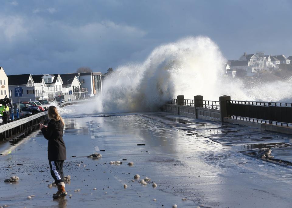
Officials are advising against travel to the coastline on Saturday as municipal and emergency crews battle the incoming storm and lingering effects of Wednesday’s storm surge.
National Weather Service meteorologists in Gray, Maine, expect about 1.25 inches of rain throughout Seacoast New Hampshire and southern Maine on Saturday. Wind gusts are expected to hit 50 mph along the coastline and 35 to 40 mph inland.
Communities further inland and parts of Strafford County may see a bit of snowfall, though the system is expected to be purely rain before mid-morning Saturday.
The storm comes on the heels of a system that blew through the Seacoast and southern Maine on Wednesday, bringing at least 2.5 inches of rain with wind gusts topping out at 74 mph at the Isles of Shoals, and widespread flooding, according to the National Weather Service. In Hampton, Police Chief Alex Reno ordered Ocean Boulevard closed from Seabrook to North Hampton as neighborhoods filled with a steep pool of water.
High tide a big factor in flooding risk for Saturday
New Hampshire state officials are warning about the danger at high tide, which will be at 12:19 p.m. Saturday in Hampton.
“With a second storm arriving in New Hampshire in less than a week’s time, it’s important that residents and visitors continue to take steps to keep themselves and their families safe,” said Robert Buxton, director of New Hampshire's Homeland Security and Emergency Management. “Stay informed of changing weather conditions and listen to instructions from local officials.”
Though projected rainfall totals for Saturday are less than what the region experienced Wednesday, high tides in Hampton are expected to reach 13.7 feet, said meteorologist Jon Palmer. That rivals Wednesday’s peak Hampton high tide of 13.66 feet reported to the National Weather Service.
“A lot of the impacts that we saw from Wednesday's coastal flooding could be possible this weekend. We’re really expecting generally the same thing pretty much across our whole coastline down in Hampton all the way up to mid-coast Maine,” Palmer said. “Tides are going to be really high across our whole coast and we could see some pretty serious flooding all the way up to the Rockland area. It’s going to be everywhere.”
Previous coverage: Homeowners at Hampton Beach clean up after storm surge
The National Weather Service is advising coastal communities in Maine and New Hampshire that Saturday's storm could result in “moderate to locally major” coastal flooding. In the aftermath of Wednesday’s storm, Palmer gave the flooding seen in areas like Hampton the same classification.
“A storm system will move across the area early Saturday morning, with gusty to damaging winds expected along the coast Saturday morning,” NWS reported. “High winds could create high storm surge, which combining with the highest astronomical tide of the month may bring substantial splash over, inundation and beach erosion.”
Hampton police planning for major flooding: Hampton Beach will be closed
Hampton Police Chief Alex Reno said they are planning for a major coastal flooding in the Hampton area on Saturday.
High tide on Saturday afternoon is at 12:20 p.m. Astronomical tides, he said, are nearly one foot higher than on Wednesday.
"Major beach erosion and coastal inundation has increased vulnerability," he said. "We anticipate flooding to begin within a few hours prior to high tide. The storm surge is predicted to be 2.5 to 3 feet, with inundation of 1 to 3.5 feet.
Reno said roadway access into Hampton Beach will be closed down starting at 10 a.m. Saturday and will reopen as the waters recede.
"We urge anyone in low-lying areas that typically flood to move vehicles to higher ground for the duration of the event," he said. "We also urge securing of items on your property that may float away in flood waters."
Reno said those who live in homes prone to flooding should seek higher ground or shelter during the storm.
"We also urge people to move from the area early to avoid being stuck and requiring emergency service rescue," Reno said.
Reno also asks people to avoid Ocean Boulevard and the sea wall.
"Ocean waves that are crashing over the walls carry dangerous debris such as large rocks, wood, traps, and other harmful items that could cause serious injury if you are struck with them," Reno said.
Reno said the state of NH and town emergency operations centers will be open during the storm. Anyone with storm-related damage to their property should call 211 to report the damage.
The town of Rye, state Department of Transportation and Seacoast emergency services are advising visitors and residents to avoid the areas of Route 1A in Rye, North Hampton, Hampton and Seabrook.
Rye is asking all boaters and surfers to avoid the water. Vehicles parked in locations used for surfing are subject to a parking ticket or towing depending on storm cleanup operations. Additionally, Rye has closed the sidewalk between the Rye, North Hampton town line north to South Road until further notice.
Rye police are asking residents and community members to avoid the intersections of Washington Road at Ocean Boulevard and Ocean Boulevard at Church Road, as those locations are still flooded from the previous storm. Rye is also requesting no vehicle or pedestrian traffic at these intersections along town roads.
What is the timing of Saturday's rainstorm?
The storm is anticipated to arrive around 1 a.m. Saturday and begin winding down by lunchtime, though rain showers are possible in the second half of the day. High winds could produce a few power outages in the Seacoast.
Mirroring Wednesday’s storm, the air could be warmer for January, with current forecasts calling for Saturday temperatures to surpass 50 degrees Fahrenheit.
Splash over and high tides carried debris and sea foam into the roadways of coastal communities on Wednesday, affecting parked cars and drivers.
Similar effects could take place on Saturday.
Officials urge people to stay away from coastline
“The two general tips we have for the public this weekend is that though we understand a lot of people are excited to see really high waves along the coast, we would strongly discourage people from going out of their way to go to the coast,” Palmer noted. “In addition, please listen to any evacuation orders that may happen.”
In Maine, the York County Emergency Management Agency issued an advisory on Thursday warning against travel to the coast on Saturday.
“We urge individuals to avoid traveling to the coast this weekend,” said Megan Arsenault, the agency’s deputy director, in a prepared statement. “Municipal officials are actively cleaning up from Wednesday’s storm damages and this weekend’s hazards could pose a serious threat to life and safety.”
“It is crucial to adhere to road closures enacted for public safety,” added Deputy Fire Chief Clif Whitten of the Old Orchard Beach Fire Department. “Do not attempt to cross barricades without consulting authorities first. Disregarding these precautions not only endangers your safety but also puts the lives of first responders at risk.”
The agency stated any residents who lost flood protection mechanisms during Wednesday’s storm could be particularly vulnerable to further damage on Saturday.
New Hampshire provides safety tips
The following is advised by the state Homeland Security and Emergency Manage
Stay informed by signing up for local alerts.
Find the latest road conditions at newengland511.org.
Slow down and move over for emergency vehicles and never crowd the plow.
Clear all snow and ice off your car, including your roof, around lights, and license plates before traveling.
If flooding occurs, get to higher ground immediately.
Just 6 inches of moving water can knock you down, and 1 foot of water can sweep your vehicle away. Use a stick to check the firmness of the ground in front of you.
Never move or drive around barriers. It can put you, other people and first responders in danger.
If floodwaters rise around your car but the water is not moving, abandon the car and move to higher ground. Do not leave the car and enter moving water. Just 6 inches of water can reach the bottom of most passenger cars causing loss of control and possible stalling.
Plan two ways out of your home in case of emergency.
Clear the driveway and front walk from ice and snow. This will provide easy access to your home.
Stay away from downed wires and call 911.
Use flashlights, rather than candles, for emergency lighting.
Check on neighbors and others who may need help.
This article originally appeared on Portsmouth Herald: Coastal flood warning in Seacoast NH, Maine

