Major storminess in the West can snarl pre-Thanksgiving travel but could also end the wildfire season

As the Thanksgiving and winter holiday seasons get underway, AccuWeather meteorologists warn that travel across the West can be slowed by multiple strong, moisture-packed storms moving ashore over the next few weeks.
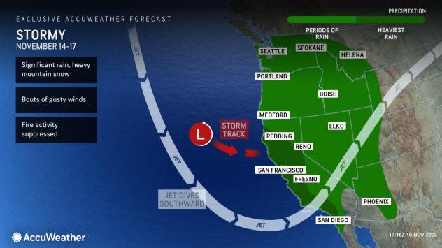
The period of stormy weather will at first be limited to the Pacific Northwest into this weekend, but then it will expand south, with impacts coming to California and the interior Great Basin region beginning next week. Next week's storms could be the first significant ones of the winter season, packing heavy rain, mountain snow and strong winds.
While detrimental to travel in the run-up to the Thanksgiving holiday, the storminess will have a silver lining: It could help put a lid on the wildfire season across a large portion of the West.
 |
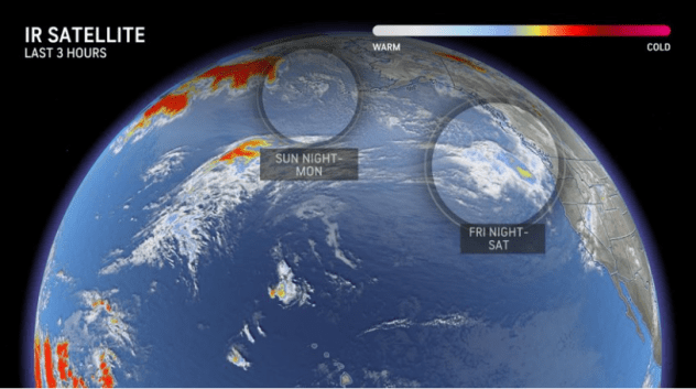
The return to wet, white and windy weather in the West actually began earlier this month when a pair of storms tracked through the Northwest and northern Rockies. AccuWeather meteorologists say those systems, and the next two storms expected to arrive in the same area later this week into the weekend, are just the beginning of what will be a stormy month.
The first storms impacted the Pacific Northwest on Thursday and brought a round of locally heavy rain to places such as Portland and Seattle that is expected to last into the weekend.
Packing moisture from the Pacific Ocean, the initial systems brought an inch or more of rain to several locations, adding to what has already been a wet start to the month in Seattle. Through Nov. 8, 4.09 inches of rain had fallen at Seattle-Tacoma International Airport, which is about 2.5 inches above the historical average for the first eight days of the month.
Unlike the storms earlier in the month, chillier air will be more prevalent into the weekend, resulting in lower snow levels that could make for some treacherous travels through the Cascade passes. In the last storm, snow levels were over 5,000 feet, but they could be as low as 3,500 feet this time around, bringing several inches of accumulation to the mountain as well as slowing travel there.
With Veterans Day commemorations and parades set to take place in the region, including the 58th annual parade and observance in Auburn, Washington, on Saturday afternoon, participants and spectators will want to have rain gear handy, if those events go on as scheduled.
"Neither of these storms headed toward the Northwest will be able to push down into California, aside from a few showers that can move into the far northwestern part of the state," said AccuWeather Senior Meteorologist Heather Zehr.
 |
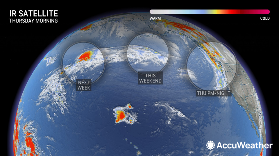
The pair of storms headed toward the West into next week, as seen on infrared satellite imagery from Friday evening, Nov. 10, 2023. (AccuWeather) |
By next week, however, the storm track that has been steering systems exclusively into the Northwest will begin to sink south through California, increasing the chance of rain from multiple storms and bringing the state its first stretch of rainy weather in months.
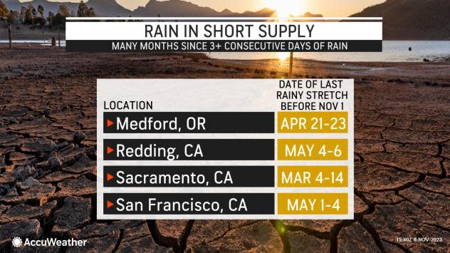
In the San Francisco Bay Area and the interior northern valleys of California, it has been about six months since it has rained for three or more consecutive days. That appears to be on the table beginning next week.
"Chances are looking good that California will pick up their first powerful storm of the wet season during the middle and end of the week," Zehr said. "The storm will feature abundant moisture and could be an atmospheric river event, packing heavy rain and the risk of flooding and mudslides."
 |
An atmospheric river features a nearly continuous flow of moisture off the Pacific into the West that can last several days. Strong, gusty winds can also accompany storms along an atmospheric river.
Ski resorts in the Sierra Nevada have also been anxiously awaiting the first major snow of the season, and that too appears to be on tap with this round of storminess. According to the U.S. Forest Service's snow depth map, only a few inches of snow are on the ground in the highest elevations of the Sierra -- that can change in a big way soon.
"Heavy snow is also likely to develop in the Sierra," pointed out Zehr. "At first, though, snow levels can be high due to warm air being funneled northward through California ahead of the storm."
The prospects of not just this first significant storm producing snow, but the storms that may follow into the succeeding week will have snow observers in the Sierra reaching for their yardsticks.
"The snow will most likely be measured in feet in the Sierra," added AccuWeather Lead Long-Range Forecaster Paul Pastelok.
 |
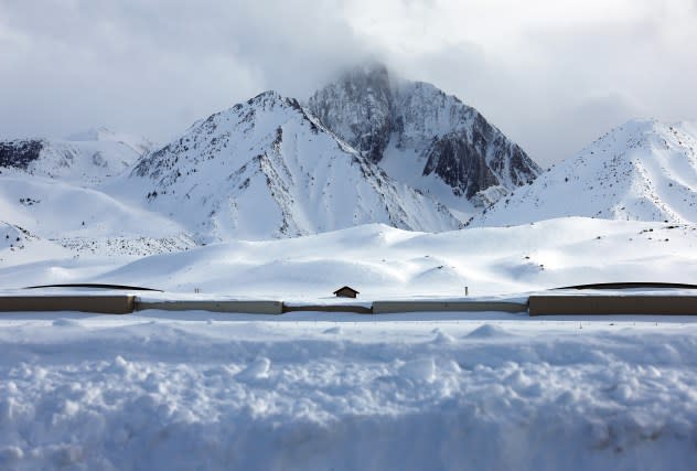
Clouds pass above the snow-covered Sierra Nevada mountains, with Mammoth Yosemite Airport buildings standing below, in the wake of an atmospheric river event which brought heavy snow to higher elevations on March 12, 2023 near Mammoth Lakes, California. (Photo by Mario Tama/Getty Images) |
The dip in the storm track could also bring some rain to Southern California during the second half of next week, potentially marking the first major rainmaker for the highly populous region since the middle of August. In Downtown Los Angeles, only 0.05 of an inch of rain has fallen since Aug. 22. While that period represents the heart of the dry season, it is still only 6% of the historical average of 0.85 of an inch.
Similar to the wet and stormy weather setting up over the southern Plains and South later this week into this weekend, the return of a wetter pattern across more of the West will come with a set of pros and cons, AccuWeather's team of long-range forecasters says.
While all of California and much of the interior West have been drought-free for months following a record-setting wet season last winter, wildfire season is currently ongoing. Any rain in the forecast will be good news in stunting the possibility of more fires.
"The series of storms that will likely impact California next week could prove very beneficial regarding wildfire concerns through the remainder of the season," AccuWeather Meteorologist Brandon Buckingham said. "They could even end up effectively ending wildfire concerns for the season."
 |
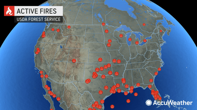
According to the InciWeb, several dozen fires are burning across the West.
"In California specifically, only 319,070 acres have burned as of Nov. 8, which is only a fraction of the average acres burned to date in years past," said Buckingham. "With the impending storm next week, it is very likely that the state will experience a well-below-average wildfire season."
On the flip side, the increased storminess on the West Coast may actually increase the risk of wildfires for a time around the Four Corners region as the wind picks up ahead of the storms.
"If next week's storm does not press into the Four Corners, there can be a multiday stretch of windy and dry conditions, elevating the risk for wildfires there," added Buckingham. "On the flip side, if rain does advance into the area from the storm, which likely would occur into Friday, it can put a lid on the season here, too."
 |
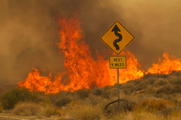
Flames rise from the York Fire on Ivanpah Rd. on Sunday, July 30, 2023, in the Mojave National Preserve, Calif. Crews battled “fire whirls” in California’s Mojave National Preserve this weekend as a massive wildfire crossed into Nevada amid dangerously high temperatures and raging winds. (AP Photo/Ty O'Neil) |
AccuWeather is also closely monitoring a potential late-season tropical system that can form in the Caribbean Sea and move up through the Greater Antilles and off the Southeast coast later next week. While thousands of miles away, this storm could actually impact the overall weather pattern farther west.
"The pattern across the country around Thanksgiving cannot be set until we know what happens with this potential tropical system," said Pastelok. "If it ends up forming and coming into the western Atlantic, it can slow down the timing of other storms across the country by at least three days."
That slowdown in the pattern could allow storminess to linger in the West right through the week including Thanksgiving, potentially imperiling travel on the days leading up to the holiday by highway and air.
Pastelok is also keeping an eye on storms in Asia and the Bering Sea, as well as any abundance or lack of cold in northern North America, which can dictate how low temperatures will be and how far south the storm track can get in the West, potentially opening up Southern California to impacts leading up to Thanksgiving.
Want next-level safety, ad-free? Unlock advanced, hyperlocal severe weather alerts when you subscribe to Premium+ on the AccuWeather app. AccuWeather Alerts™ are prompted by our expert meteorologists who monitor and analyze dangerous weather risks 24/7 to keep you and your family safer.
