East Coast blizzard rages overnight, 50+ cm snow possible
A major winter storm rolling across the East Coast to end the week will produce blizzard conditions and drop half a metre of snow on parts of the region by Saturday morning.
Areas expecting snowfall and gusty winds will see difficult to near-impossible travel conditions as a result of the reduced visibility and snow-covered roads. 50+ cm of snow is possible for parts of Newfoundland by the end of the storm.
The dangerous conditions will last for another 24 hours for some.
PHOTOS: Blizzard conditions blast Newfoundland
This storm arrives less than a week after another impactful storm hit Atlantic Canada, knocking out power to hundreds of thousands of homes and businesses across the Maritimes.
While that earlier storm featured unseasonably warm air, the current system roaring over the region has enough cold air to pack a wintry punch.
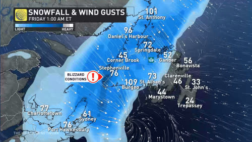
Powerful winds and heavy snowfall will lead to blizzard conditions through the remainder of the storm, with the highest snow totals and longest spell of near-zero visibility focusing on western Newfoundland and Nova Scotia’s Cape Breton.
Heavy snow and blustery conditions will persist overnight Thursday into the day Friday. Snow will eventually spread across Newfoundland through the day Friday, with light snow reaching St. John’s by the evening.
Freezing rain is likely as rain transitions to snow, leaving a dangerous coat of ice beneath the eventual blanket of snow.
Snowfall will taper off from west to east by Saturday morning.
WINTER 2024: El Niño will play a critical role in the weeks ahead
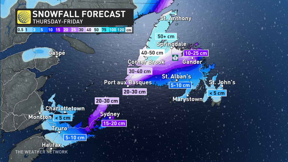
Widespread snowfall accumulations of 30-50+ cm are expected across western Newfoundland, with the hardest-hit areas likely from Corner Brook north across the Great Northern Peninsula.
Nova Scotia’s Cape Breton is in for a decent wallop, as well, with 15-20 cm expected through Friday near Sydney and higher totals yet for higher elevations. Elsewhere, several centimetres of snow is in the forecast for most of northern Nova Scotia and Prince Edward Island.
Conditions will remain blustery and colder as the storm departs the region. Fair weather and milder temperatures are in the cards for Christmas Eve and Christmas Day across the Maritimes, with temperatures in the middle to upper single digits. Readings will remain closer to seasonal across Newfoundland.
Stay with The Weather Network for the latest forecast as you plan your holiday weekend.

