Major winter storm brewing with snow, ice and rain to blast Northeast


- Oops!Something went wrong.Please try again later.
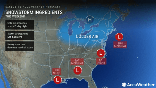
Millions in the Northeast could soon experience their first widespread significant winter storm of the season and maybe years. A cross-country storm, which will begin by bringing rain and snow to the West Coast midweek, is forecast to intensify in the eastern U.S. late in the week, dishing out a major storm in time for the weekend. For many locations in the Interstate 95 corridor, this could be the biggest snowfall in two winters.
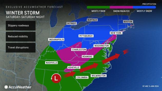
AccuWeather meteorologists anticipate major travel disruptions on the roads and at the airports from the storm in the Northeast due to a wide variety of precipitation on the way for this weekend. The anticipated timing of the storm may allow for better travel on Friday night and Saturday morning, as opposed to Sunday.
Property owners may want to brush the dust off their snow shovels and snow blowers and have ice-melting compounds ready. Highway departments and townships may also want to review their plan of action ahead of the storm.
After spreading snow across the southern Rockies and into the southern Plains Thursday and Friday, the storm is set to strengthen across the Southeast into early Saturday, tapping into moisture from the Gulf of Mexico.
 |
"The storm is expected to blossom across the Southeastern states to start the weekend, likely bringing along a swath of heavy rain and thunderstorms before pulling northward," Meteorologist Brandon Buckingham said.
As the storm moves northeast, it is forecast to collide an area of colder air in place across the Great Lakes and Northeast, allowing for a zone of snow to unfold.
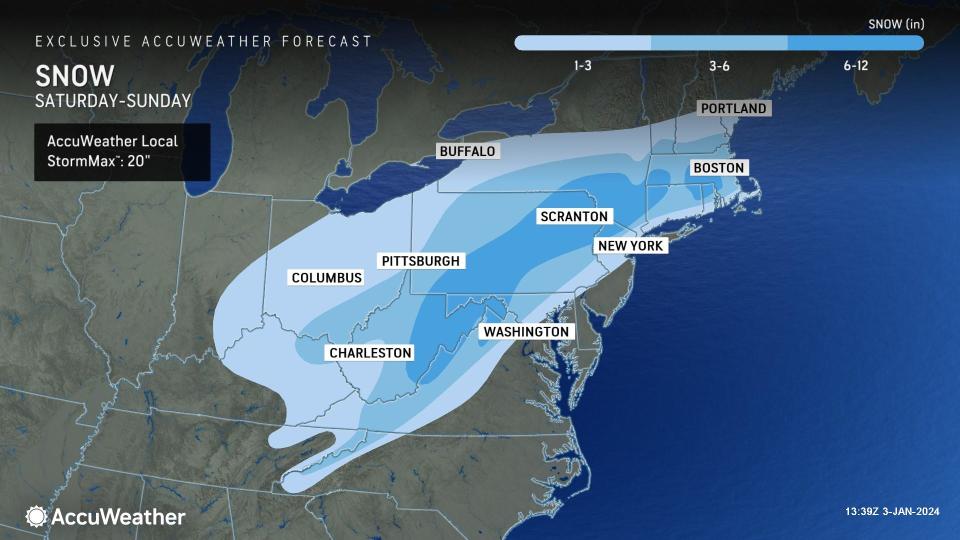
The area of the snow is likely to expand rapidly once the storm's moisture reaches the central and southern Appalachians, as well as parts of mid-Atlantic and southern New England by late Saturday. Motorists venturing along Interstates 64, 68, 70, 76, 79, 80 and 81 should expect travel conditions to quickly transition deteriorate, transitioning from dry to wet, slushy and snow-covered into Saturday night.
 |
Snow is forecast to spread from south to north as the storm shifts from the southeastern U.S. to off the mid-Atlantic Coast. A strengthening storm would also allow for an area of more than 6 inches to unfold in the interior Northeast, and perhaps even in pockets of southern New England.
How much snow ends up falling along the I-95 zone from Washington, D.C., to Philadelphia, New York City and Boston will depend on the track and strength of the storm. Many storms that approach from the south in this manner tend to pull warm air in from the Atlantic Ocean, often leading to an abbreviated period of snow or wintry mix. Water temperatures in the nearby Atlantic are generally in the 40s F, so an east-to-northeast wind from the water will bring that milder ocean air inland. A more northerly wind during the storm could prevent the warming effect of the Atlantic.
"There is a chance that accumulating snow can fall all the way to the Atlantic coast in the Northeast, depending on if cold air holds its ground to the north and the storm takes a track out to sea, rather than right along the coast," Buckingham said. In this case, winds would be more from the north and a wedge of cold air is more likely to remain in place.
 |
"The effects of the warmer ocean water could help contribute to a sharp variation in snowfall totals as you go from places like Central Park in New York City and Center City Philadelphia outward towards the suburbs," said AccuWeather Senior Meteorologist Courtney Travis. Higher snowfall totals are most likely for the northern and western suburbs of both these cities, with lesser amounts to the south and east.
"The most significant wintry effects from the storm will be limited to about 12 hours or so from late Saturday into Sunday evening," Travis explained.
This is because the storm should keep moving rather than stall and intensify. Storms that linger have the potential to bring a few feet of snow. However, because this storm is likely to keep moving, a general 6-12 inches is likely where snow falls with locally higher amounts. Where rain takes over quickly, little to no accumulation of snow is likely. A wintry mix or ice could limit snowfall accumulation to a few inches or less.
If the storm keeps rolling along to the Northeast, rather than turning out to sea off the mid-Atlantic coast, road conditions are likely to deteriorate in New England and upstate New York, including the New York Thruway, the Massachusetts Turnpike and portions of I-89, I-91, I-93 and I-95 on Sunday and Sunday evening. However, a track that takes the storm off the mid-Atlantic coast and out to sea could result in little or no snow for the northern parts of New York state and New England.
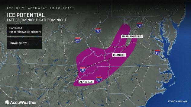
The wedge of cold air in the Northeast may also be pulled southward, allowing for ice over interior portions of the mid-Atlantic. Depending on whether mostly freezing rain occurs versus sleet, a buildup of ice may occur on trees and power lines in some locations.
 |
Even just a little bit of sleet or freezing rain could leave any untreated roadways and sidewalks slippery and cause travel delays.
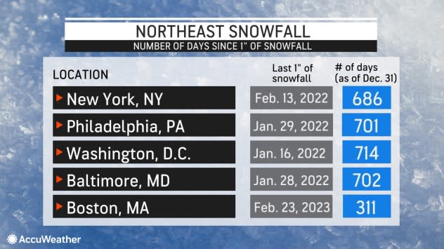
For snow lovers in the Interstate 95 corridor, it has been a long wait for even an inch of snow. In fact, early 2022 was the last time most locations from the New York City area to central Virginia. This storm could change that.
 |
The last time there was an inch of snow from a single storm in New York City was on Feb. 13, 2022, or 689 days as of Jan 3, 2024. For Philadelphia, the last time there was a snowstorm that brought at least an inch of snow was on Jan. 28-29, 2022, or a whopping 704 days, as of Jan. 3. Washington, D.C., has not picked up close to an inch of snow since Mar. 12, 2022, when 0.9 of an inch fell.
The lack of heavy snow over such a long period could have some motorists out of winter driving practice. As a saving grace for most commuters, this storm will focus on the weekend rather than the busy weekdays.
 |
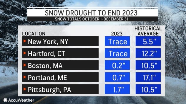
As the snow drought continues along much of the I-95 in the mid-Atlantic, snow has also been very lean across the central Appalachians, Great Lakes region and coastal New England. Many locations have received less than a third of their historical average snowfall, with some areas under 10% of the average.
Even in one of the snow capitals of the Northeast, Buffalo, New York, less than 6 inches of snow has fallen from Oct. 1 to Dec. 31, compared to a historical average of 25.3 inches.
AccuWeather will continue to provide updates on the storm through its various media sources, including the AccuWeather APP, website and the AccuWeather Network, and its radio, TV and newspaper affiliates.
Want next-level safety, ad-free? Unlock advanced, hyperlocal severe weather alerts when you subscribe to Premium+ on the AccuWeather app. AccuWeather Alerts™ are prompted by our expert meteorologists who monitor and analyze dangerous weather risks 24/7 to keep you and your family safer.
