Winter weather advisory for Greater Akron on Friday, heavy snow possible
So far the odds have been in our favor when it comes to major snowstorms this wintery season.
It seems the odds may have run out.
The National Weather Service says the latest storm is expected to track roughly along state Route 30 putting Akron on the edge of a chance for some fairly significant snowfall as a mix of rain and snow is expected.
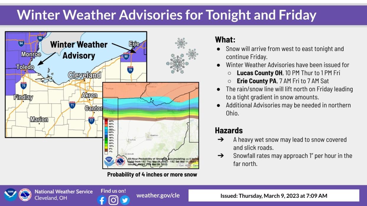
A winter weather advisory has been issued for Medina, Summit and Portage counties from 4 a.m. Friday through 7 a.m. Saturday.
It is possible as much as 4 inches of snow could fall in the northern areas of the impacted counties.
The weather service puts the odds of Greater Akron receiving 4-plus inches of snow at 30 percent.
If the storm system tracks a bit farther south, the odds increase for heavy snow and less rain.
A wobble to the north lessens the odds as more rain will mix in.
Either way, it looks like northern Ohio will see some snow on Friday into Saturday, with the potential for more snowfall in the traditional snowbelt thanks to an ice free Lake Erie.
The weather service says the snowfall might be heavy at times early Friday morning, with as much as half an inch an hour is possible.
There is expected to be a lull Friday afternoon, when temperatures warm above freezing.
What's the forecast for northern Ohio?
Thursday night: Snow likely before 5am, then rain, possibly mixed with snow. Low around 33. East wind 6 to 10 mph. Chance of precipitation is 80%. Total nighttime snow accumulation of less than a half inch possible.
Friday: Rain and snow before 1 p.m., then rain between 1pm and 4pm, then snow, possibly mixed with rain after 4 p.m. High near 37. East wind 7 to 14 mph becoming west in the afternoon. Chance of precipitation is 100%. New snow accumulation of around an inch possible.
Friday Night: Snow showers, mainly before 1 a.m. Low around 27. Northwest wind 10 to 17 mph. Chance of precipitation is 80%. New snow accumulation of less than one inch possible.
Saturday: A chance of snow showers, mixing with rain after 10 a.m., then gradually ending. Cloudy, with a high near 35. North wind 6 to 10 mph. Chance of precipitation is 30%. New snow accumulation of less than a half inch possible.
Saturday night: Mostly cloudy, with a low around 24. Light and variable wind.
Sunday: A chance of rain and snow showers before 1 p.m., then rain showers likely. Mostly cloudy, with a high near 40. Chance of precipitation is 60%. New snow accumulation of less than a half inch possible.
Sunday night: Rain showers likely before 1am, then rain and snow showers likely. Cloudy, with a low around 32. Chance of precipitation is 70%.
Monday: A chance of rain and snow showers. Cloudy, with a high near 38. Chance of precipitation is 40%.
Monday night: A chance of snow showers. Mostly cloudy, with a low around 23. Chance of precipitation is 50%.
Tuesday: A chance of snow showers before 1 p.m. Mostly cloudy, with a high near 32. Breezy. Chance of precipitation is 30%.
Tuesday night: Partly cloudy, with a low around 21. Blustery.
Wednesday: Sunny, with a high near 42.
Wednesday night: Mostly cloudy, with a low around 29.
Thursday: Mostly cloudy, with a high near 49.
This article originally appeared on Akron Beacon Journal: Winter weather advisory for Akron: Heavy snow possible Friday

