New map shows Manatee County manufactured homes sustained major damage from Hurricane Ian
Manatee County officials braced for the worst in the days leading up to Hurricane Ian's landfall when many forecast models predicted the storm could smash straight into Tampa Bay.
Ian's eye passed about 22 miles from Manatee, and the county was largely spared from the Category 4 storm. Agricultural communities in East Manatee were devastated by heavy winds and the worst of the county's flooding. Myakka Elementary was the last school to return to session in the school district.
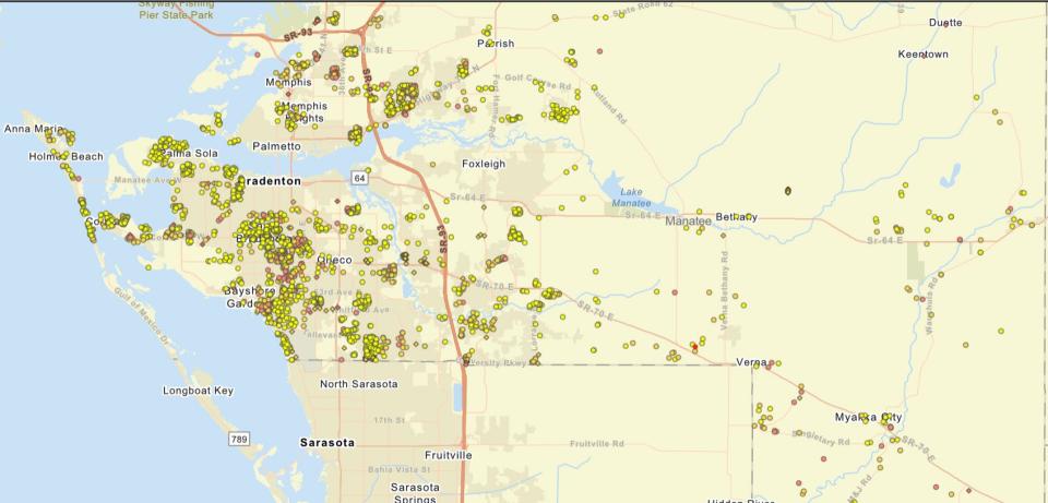
A new map by Manatee County shows that most of Hurricane Ian's structural damage occurred in western Manatee County, where winds battered more populated areas in older parts of the community and many manufactured home parks.
More Hurricane Ian: Farmers, others in Manatee County face millions in damage from Hurricane Ian
Hurricane deaths: Hurricane Ian-related deaths climb in Sarasota, Manatee counties. Here’s what we know.
And: Aerial video shows massive flooding in Manatee County, Florida
The map is still being updated with new data, so the numbers are not final, but it shows that 1,791 residential buildings and 273 commercial buildings were damaged by the storm countywide as of Wednesday afternoon.
Manatee County is among several local governments using Crisis Track disaster management software to track hurricane-related damage and report it to state and federal agencies. The county is able to produce a map with the data that sorts damaged buildings into four categories: destroyed, major, minor or affected.
Manatee County Code Enhancement Supervisor Kris Weiskopf said officials had to use a pen, paper, and GPS-enabled cameras during previous storms, but that the new software has made the process faster and more streamlined.
"We were much more effective in being able to report damage, numbers, and dollar amounts of damage than the old ways," Weiskopf said. "Even as of the Irma days back in 2017, we were talking paper and cameras."
The map shows many of the buildings that sustained "major" damage were located in many of of the county's mobile home communities like Trailer Estates Park, Heather Hills and Twin Oaks in Southwest Manatee County, Colony Cove in Ellenton, and Coach House Mobile Home Park in Palmetto.
"Those area is heavily populated, anywhere from that south county area to U.S. 301 and Samoset, those are heavily populated areas," Weiskopf said. "The further you get out east, the homes get more sparse."
"Overall, the county was lucky in the minimal damage that we sustained," he said. "Most of the damage, dollar-wise, and number-wise, was all in the 'affected' category."
Pat Wenzel, a building department official with the city of Bradenton, said most buildings in the city were spared. He did not see any flooding or much of the wind damage sustained in communities just south of the city limits. He said most of the debris in the city was from damaged trees, some rooftops, and structures like lanais.
He said storm damage can sometimes be confounding, and unlike the nearby manufactured home parks that sustained significant damage, he said the two parks inside the city limits were largely spared.
"The Manatee Mobile Home Park and Braden Castle, two very old mobile home parks, I only heard of one trailer that lost its roof," Wenzel said. "Braden Castle seems to have gotten by with nothing. No damage whatsoever. It's a strange old park."
This article originally appeared on Sarasota Herald-Tribune: Hurricane Ian: Map shows major damage to Manatee manufactured homes

