Mapped: The wildfires devastating British Columbia in Canada
Canada is again battling an outbreak of deadly wildfires, with British Columbia forced to declare a state of emergency after a number of severe blazes broke out in the area surrounding Vancouver.
The predominantly rural region under threat stretches south of the country’s border with the United States into northern Washington and east into the neighbouring province of Alberta, where the cities of Calgary and Edmonton are situated.
Severe fires are also burning around Yellowknife in the Northwest Territories.
Fortunately, the fires in British Columbia showed some signs of easing on Sunday, giving hope to firefighters who have been at the forefront of an "epic" battle, although authorities are warning of a long road to recovery.
More than 35,000 people have been driven out of their homes in the western Canadian province since the fires began late last week, forcing the federal government to deploy the military to help with the relief efforts.
British Columbia has also banned non-essential travel to ensure adequate accommodation is available to people displaced by the fires.
The Pacific coast province could get some rains this week from the moisture of Tropical Storm Hilary, which made its historic arrival in California on Sunday, bringing some relief to a province in the grip of a severe drought.
Jason Brolund, fire chief of West Kelowna, one of the worst affected areas by the fires, said conditions have improved which is helping firefighters put “boots on the ground”.
“We haven’t been challenged with extraordinary fire behaviour. We are dealing with things like we are used to seeing. However, we are dealing with them on an epic scale,” Chief Brolund told the Canadian Broadcasting Corp.
Still, he warned of difficult days ahead.
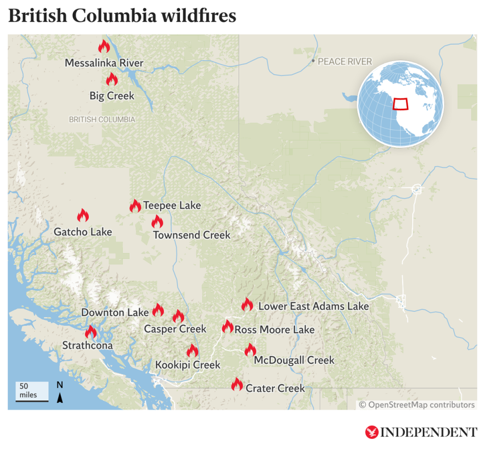
The map below presents locations in British Columbia worst hit by the wildfires as of Monday 21 August.
For a more complete picture of the national situation, Natural Resources Canada has its own interactive live map illustrating the current state of play as it continues to evolve.
Forest fires are far from uncommon in Canada but the spread of blazes and disruptions seen already this summer underscore the severity of its worst wildfire season yet, which some experts have blamed on the climate crisis.
About 54,054 square miles of land, roughly the size of New York state, have been scorched nationwide this year, with smoky haze extending as far as the US East Coast and New York City in June.
Government officials project that the fire season could stretch into autumn because of widespread drought-like conditions.
The wildfire burning out of control in Yellowknife, the capital of the Northwest Territories, has similarly turned the remote interior city into a smoky ghost town with almost all of its 20,000 residents evacuated.
Some 400 Canadian armed forces personnel are helping the province’s government deal with the fire, which remains “fluid”, a statement issued by National Defence on Sunday said. Fires continue to burn about nine miles from the city and it is currently unclear when it might reach it.
Local officials told reporters on Sunday there is no timeline yet for bringing back the evacuated residents to their homes in Yellowknife unless it is safe to do so.
Additional reporting by agencies

