Significant warmup ahead for midwestern, northeastern US following invasion of extreme polar cold
Temperatures can swing upward by as much as 80 degrees Fahrenheit from the lowest levels amid the polar vortex invasion as the midwestern and northeastern United States are treated to a taste of March to start February.
January ended on a brutal note in the Midwest and Northeast as deadly Arctic cold invaded. Record lows were broken as the cold led to widespread school closures, major travel disruptions and even the suspension of mail service.
The departure of the polar vortex will be followed by a change in the weather so dramatic that many residents will be wondering if the calendar has been flipped ahead to March instead of February.
After being held below zero for one to three consecutive days, temperatures from central Minnesota to northern Illinois can trend upward to the 30s and 40s this weekend.

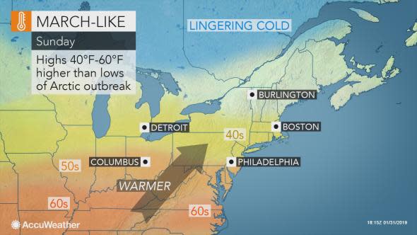
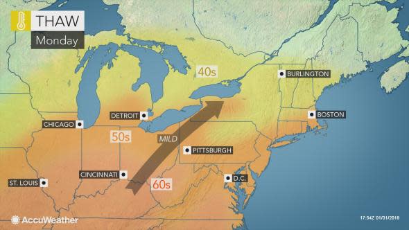
The warmth is also expected to surge across all of the Midwest, mid-Atlantic and into New England Sunday into early next week.
On the warmest day, highs to around 60 are anticipated northward to the Interstate 70 corridor from St. Louis to Washington, D.C. Even Philadelphia can flirt with the 60-degree mark.
Highs in the 50s may have residents in Chicago, Detroit, New York City and Boston replacing winter jackets with lighter spring attire.
This change will mean an average positive swing of 40 to 60 degrees from the lowest actual temperatures endured during the polar vortex's invasion to the highs at the peak of the warmth.
For Chicago, Minneapolis and other parts of the Midwest that endured the harshest cold of the Arctic outbreak, the upswing in temperatures can be as high as 70 to 80 degrees.
"While the warmth is encouraging, there are some pitfalls that can derail the extreme warmth that is being projected," according to AccuWeather Senior Meteorologist Dave Dombek.
"The places where there is snow and ice cover, we have to be concerned that the warmup stops short of expectation," Dombek said.
Wind blowing in off colder bodies of water, a thick cloud cover and cold air becoming trapped in the deepest valleys can also limit the warmth in some communities.
"On the other hand, the warmth can easily be achieved or even overachieved where the ground is bare," according to Dombek.
Download the free AccuWeather app to find out temperature trends in your community.
A break from the cold is definitely great news for residents dealing with higher heating costs, frozen pipes and animals and kids cooped up due to concerns over frostbite and hypothermia.
On the days when the warmth is not spoiled by rain, fog or drizzle, streets may be filled up with residents taking walks or enjoying other outdoor activities in the fresh air.
"The sudden warmup could lead to ice jam flooding on some rivers as large chunks of ice break loose and jam the flow of water downstream," according to AccuWeather Meteorologist Bill Deger.
"Such flooding can be sudden and lead to bridge closures and travel delays," Deger said.
"Fortunately we do not expect long-lasting heavy rain to hit at the same time with the warmup," according to AccuWeather Senior Meteorologist Alex Sosnowski.
"This should allow a more gradual thaw and minimal amount of ice-jam issues in the short term," Sosnowski said.
More potholes may be unearthed as temperatures rebound.
AccuWeather meteorologists are also concerned for freezing drizzle to develop across parts of the Midwest this weekend.
Since roads and sidewalks can stay colder longer than the air temperature after an Arctic outbreak, the drizzle can create icy patches on untreated surfaces even well after thermometers have cracked the freezing mark.

This danger can shift to northern Pennsylvania, upstate New York and neighboring parts of New England on Sunday.
Despite the turn to milder weather, Dombek reminds everyone from skiers hoping for more snow, to warm-weather fans wishing for early spring, that winter is far from over.
"Think back to times in early August when it is cool, can you really say that summer is over? No," he said. "That is the case now for winter. It is way to soon to say that winter is over."
That will be evident as the warmth will be gradually be trimmed from west to east across the nation's northern tier next week.
The core of the Arctic outbreak to target the United States next week is expected to be focused on the northern Rockies and northern Plains, according to AccuWeather Lead Long-Range Meteorologist Paul Pastelok.
The colder weather will be far from as extreme as what was endured this week farther east. However, for folks in Montana and the western part of the Dakotas, this blast will be colder since this week's blast was centered over the Midwest.
As the colder weather returns, it will feel typical for the second weekend of February in the Northeast and mid-Atlantic.
This week's episode of Everything Under the Sun covers two topics. First, host Regina Miller talks to Punxsutawney Phil's handler, John Griffiths for a fun look at the history and tradition of Groundhog Day. Then Regina discusses the polar vortex with AccuWeather's long-range team. What is it and what impact will it have on the length of the winter cold? Tune in to find out!