Massive 'atmospheric river' to bring heavy rains, winds, flooding across California
After a brief lull in precipitation Tuesday, forecasters are warning of another "atmospheric river" expected to bring heavy rains and winds to an already saturated California.
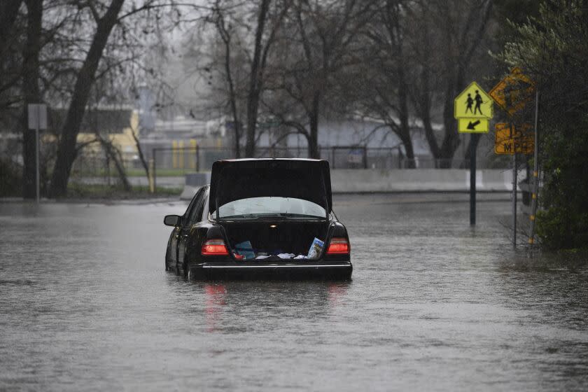
The National Weather Service is warning of "widespread flooding" and strong winds across the state Wednesday and Thursday, with the most dangerous conditions expected in Northern California — a region that has already seen significant flooding and power outages this week.
"It's going to be a very impressive storm Wednesday and Thursday," said Rich Thompson, a National Weather Service meteorologist in Oxnard. "An atmospheric river moving over the entire state of California."
Weather officials are tracking a strengthening cyclone, or "bomb cyclone," moving across the Pacific toward California's northern coast, creating a strong band of moisture and cold front.
The hazard risks and heavy precipitation will be felt “just about everywhere from the Monterey Bay area northward, with some risks even extending south into Los Angeles County," UCLA climate expert Daniel Swain said in a briefing Tuesday.
The heaviest rainfall is likely to be focused in the north and central coastal ranges and the Sierra foothills north of the Bay Area, he said.
Among the chief concerns are strong winds, high rainfall rates and the potential for landslides and flooding, including urban and creek flooding in areas already soaked. Swain said residents who have seen signs of landslides and debris flow over the last several days should remain alert.
“The Wednesday night storm at least is definitely one that could produce new mudflows or exacerbate existing ones,” Swain said. “For tomorrow night, that might be a good night to be vigilant or activate whatever plans you have for storms like that, if you live in that kind of terrain.”
In the short term, the next surge of heavy rain is expected to move onshore California on Wednesday, January 4th. A Moderate Risk of Excessive Rainfall has been issued for the northern and central California coast, where numerous flash floods and runoff concerns are likely. #CAwx pic.twitter.com/jC8A8Jy5uj
— NWS Weather Prediction Center (@NWSWPC) January 3, 2023
The state has already seen multiple days of significant rainfall, first from a massive New Year's Eve system and then a smaller storm that moved in Monday night.
Northern California fared the worst in the New Year's storm, with substantial flooding forcing rescues and some evacuations, and thousands of Californians losing power in parts of Sacramento and San Francisco. More than 2,000 in Sacramento remained without power Tuesday, according to the Sacramento Municipal Utility District.
City and state officials were calling Tuesday's break between storms a chance to prepare for the worsening weather, handing out sandbags in many Northern California cities, working to clear storm drains and downed trees, and asking residents to prepare homes and evacuation plans.
“We already have some ongoing flooding in the area ... and we're expecting more heavy rain," said Scott Rowe, a meteorologist with the National Weather Service in Sacramento.
The Sacramento Valley can expect 2 to 3 inches of rain from Wednesday through Friday, while some areas in the foothills could see up to 6 inches — on top of the multiple inches from days prior, he said. San Franciscans can expect to see at least 2 more inches of rain from the midweek storm.
Flood Watches have been posted across the Bay Area and much of NorCal Wednesday into Thursday with the next atmospheric river. pic.twitter.com/IU8wZxPaBo
— NWS Bay Area 🌉 (@NWSBayArea) January 2, 2023
Along the narrow creek that separates San Mateo and Santa Clara counties in the Palo Alto area, residents braced for the incoming storm, still reeling from Saturday’s deluge.
On New Year’s Eve, the typically dry creek swelled over its banks, flooding patios, streets, parking lots and stores throughout East Palo Alto, Palo Alto and Menlo Park — including the entrance of Menlo Atherton High School’s Performing Arts Center.
At the Chaucer-Pope Bridge — a small, two-lane span connecting Menlo Park and Palo Alto — water rose just inches shy of its 24-foot capacity. The volume of water moving through the creek on Stanford University’s property — at 7,420 cubic feet per second — exceeded the 1998 record of 7,200 cubic feet per second.
On Tuesday, work crews and residents were out preparing for the next storm.
Rowan Lee was shoveling sand from a pile on Palo Alto Avenue into bags, which she and her family then carried across the street to their Palo Alto house, which flooded Saturday.
She said they were alerted Saturday of the flood risk only 30 minutes before the creek spilled over its banks.
“It got into our garage,” she said, but the rest of the house was spared.
Stanford’s Lake Lagunita, which has been dry for years, was partly filled Tuesday from the recent rainwater, attracting geese and ducks.
Cities across the peninsula were providing sandbag pickups for residents, while urging people to stay home and keep street gutters clean as the storm moves in early Wednesday.
San Francisco Mayor London Breed warned residents that the storm could inflict a heavy toll.
“We were under the impression we could anticipate not even an inch of rain” before the New Year's Eve system, she said. Instead, the city received 5.5 inches of rain, “the second-largest amount of rain in a 24-hour period," Breed said.
“It was so out of range, but we were still able to respond,” she said. Despite being unprepared, Breed said, the city reacted swiftly: cleaning storm drains, providing sandbags, addressing downed trees, mudslides and flooding.
Meteorologists are anticipating 2 to 3 inches of rain for the midweek storm, along with dangerously strong winds, the mayor said. She urged people to use 911 only for life and death emergencies, and said the 311 lines should be utilized for non-life-threatening situations, such as flooding.
A flood watch has been extended across much of the state, from parts of Orange County up through northwest California, beginning Wednesday and stretching through Thursday evening, with warnings of "excessive rainfall" that will probably cause even more flooding. Earlier rains raised water levels on the Cosumnes River near Sacramento to record heights, breaching three levees and inundating nearby areas.
Certain burn scars in northwest California and into the central Sacramento Valley have been upgraded to a flash flood watch. While burn scars and other flood-prone regions are particularly vulnerable, there is growing flooding potential in urban areas and around small streams, as well as for some rivers, said Eric Boldt, a National Weather Service meteorologist in Oxnard.
The looming storm is expected to also bring heavy winds to the state — up to 50 to 60 mph for the Sacramento Valley, Rowe said. A high-wind warning for Wednesday and Thursday was also issued for the greater Bay Area and central coast, warning of gusts up to 70 mph.
In the mountainous northeast — from Sequoia National Park through the greater Lake Tahoe area and toward the Oregon border — the National Weather Service has issued a winter storm warning for Wednesday and through Friday morning, with forecasts showing heavy snowfall dropping up to 4 feet of snow and wind gusts up to 55 mph.
Rowe warned that people should expect widespread tree damage and possible power outages.
Southern California also saw heavy rains this week but was spared the widespread disruptions — even with the Los Angeles area recording 2 to 5 inches from the New Year's storm, and then a quarter-inch late Monday from the smaller storm, according to the National Weather Service.
Thompson called Tuesday a "temporary drying out" for the L.A. area, before the rain picks back up again Tuesday evening, becoming heavier through Thursday. He said most of Los Angeles County could see an additional 2 to 4 inches of rain during those days, with some areas getting up to 6 inches.
"We're definitely looking at a lot of rainfall for this," Thompson said.
With high winds also expected, forecasters predicted rush hour Thursday morning could become a nightmare, with minor flooding, the potential for fallen trees and other debris on the road, and possible power outages. Winds in Southern California are expected to reach 30 to 50 mph in the coasts and valleys, and up to 60 mph in the Antelope Valley and mountains.
Impactful weather continues...
Light precip. across northern Sacramento Valley today
Strong system arrives Wed-Thu with strong winds, heavy rain & mountain snow
Friday lingering showers & residual flooding impacts
Weekend & beyond...unsettled weather likely continues. #CAwx pic.twitter.com/insN99azAP— NWS Sacramento (@NWSSacramento) January 3, 2023
"Thursday morning could be quite a challenge for people trying to get to and from work or other places," Boldt said.
Thompson also warned of hazardous coastal conditions during the storm, with high surf Thursday and Friday that could cause coastal flooding and beach erosion.
But even at the end of the week, weather officials are warning that the moist weather pattern is likely to continue for the foreseeable future, though the timing and intensity of these systems are not yet certain.
"As we get into Sunday and early next week, there's still potential for some wet events, just not as strong as what we're expecting Wednesday and Thursday," Boldt said. "We'll continue to see rainfall going into next week."
Officials advise people to sign up for county emergency alerts, fuel up vehicles and charge devices in case of power outages and be prepared to evacuate, especially if homes are in flood-prone regions.
Times staff writers Hayley Smith and Brittny Mejia contributed to this report.
This story originally appeared in Los Angeles Times.

