Massive weekend storm to pack a punch for millions in eastern half of US


Even though a large weekend storm may end up being a "late bloomer" in terms of disruptive conditions, it will have impacts in an area of the eastern half of the United States, including an estimated 180 million people, as areas of heavy rain, strong winds, snow and severe thunderstorms develop, AccuWeather meteorologists say.
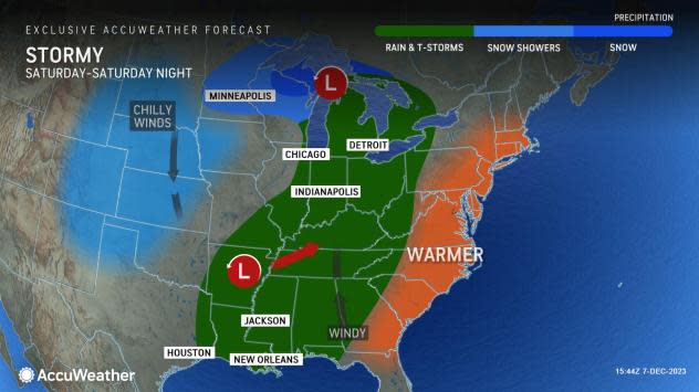
The storm will strengthen, but that process will be delayed until it advances from the Mississippi Valley to the Atlantic coast, where it can pack a punch, AccuWeather Meteorologist Joseph Bauer said.
 |
"The strengthening delay will limit the amount of wind the Great Lakes region experiences and the amount of rain and snow that falls over much of the Central states," Bauer said.
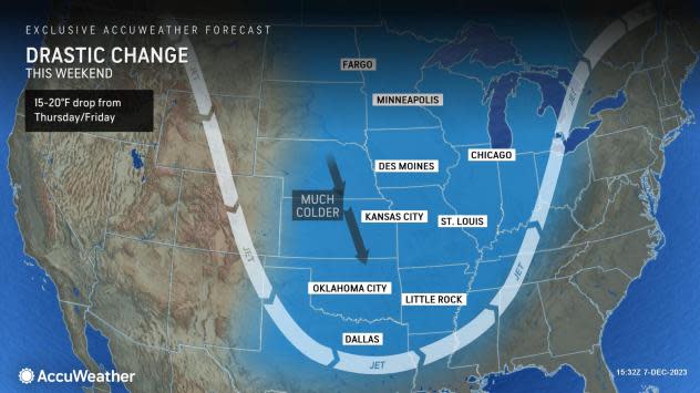
One of the big factors against much snow from a more moderate storm as opposed to a powerhouse system is the extent of warm air in front of the storm. Temperatures will surge well above the historical average for early December -- in some cases, temperatures will peak 15-25 degrees above average. A strong or quickly strengthening storm would be able to manufacture cold air while a weaker one would not.
With this in mind, the overall extent of snow and the amount of snow that falls in the Central states will be generally limited to parts of the northern Plains and the Upper Midwest.
 |
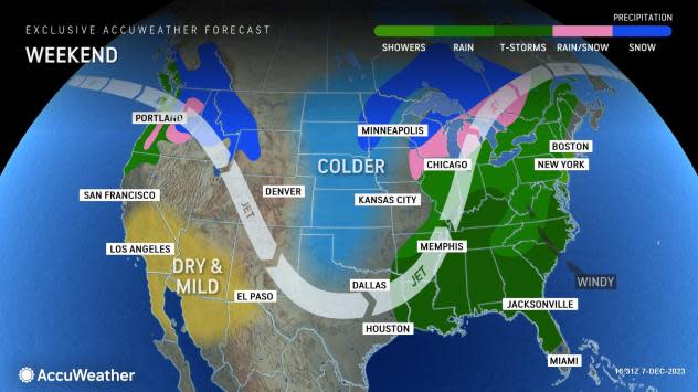
A general 1-3 inches of snow will fall on eastern parts of the Dakotas and western Minnesota, as well as a zone from western and northern Wisconsin to the Upper Peninsula of Michigan. Within both zones, a pocket of 3-6 inches of snow is likely to occur.
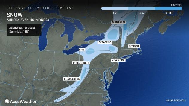
The highest chance of accumulating snow will be in parts of the Appalachians and the interior Northeast as the cold air rushes in behind a strong cold front Sunday afternoon into Sunday night, AccuWeather Meteorologist La Troy Thornton said.
Portions of western, central and northern New York, northern Vermont, northern and western Pennsylvania, as well as the ridges from western Maryland to West Virginia, may pick up several inches of snow during Sunday night as the colder air charges into the back side of the rain.
 |
One zone that has a higher chance of picking up 6 inches of snow during Sunday night is from northern Vermont to southern Quebec.
Much of the rain may be sporadic and showery over part of the Mississippi Valley.
However, AccuWeather meteorologists remain concerned about severe weather over a broad area from the central Gulf coast to the Ohio Valley on Saturday and Saturday night. Warm air and less cloud cover may compensate for a less intense storm system, leading to powerful thunderstorms and perhaps a few tornadoes.
 |
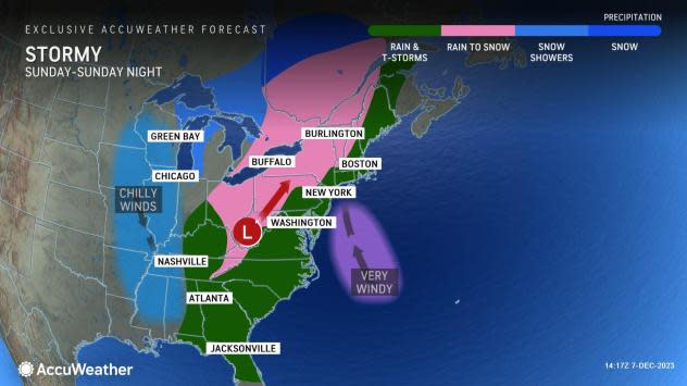
As the storm progresses northeastward, it will gain strength and pull moisture from the Gulf of Mexico later Saturday then from the Atlantic Ocean by Sunday. The surge in moisture will lead to more fuel for thunderstorms and rain on the eastern half of the Mississippi Valley to the Appalachians and Atlantic coast while the strengthening storm and trailing cold front will generate much stronger winds from the Appalachians to the Atlantic coast during the latter part of the weekend.
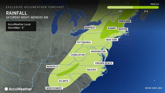
At the very least, a period of heavy rain, accompanied by strong winds and thunder and lightning in some cases, will shift eastward from the Florida Panhandle to Ohio, western Pennsylvania and western New York during Saturday night to an area spreading from northeastern Florida to eastern New York during the day Sunday.
 |
The heavy rain, thunderstorms and strong winds will pivot across much of New England during Sunday night as powerful storms push through South Florida.
Winds will be screaming a couple thousand feet up from the ground on Sunday and Sunday night along the Atlantic coast, AccuWeather Meteorologist Grady Gilman said.
"High winds in the lower part of the atmosphere may be dragged down to ground and sea surface level in the form of powerful gusts ranging from 40-60 mph along the Interstate-95 zone from Sunday afternoon to Sunday night," Gilman added. A narrow zone with wind gusts between 60 and 70 mph is most likely along the New England coast and in eastern Long Island, New York.
 |
There is an AccuWeather Local StormMax™ wind gust of 85 mph with the storm in coastal New England. At this strength, tree damage can occur, which can block some roads, trigger widespread power outages and cause significant property damage. Strong southerly winds can lead to flooding along south-facing exposed beach communities as well as the locations along inland bays.
During a several-hour period, the rain may pour down at the rate of 0.50 of an inch to 1 inch per hour at times.
"Heavy rainfall will accompany the frontal passage and can cause flooding on streets and highways along with reduced visibility," Gilman said, adding, "Significant ground and air travel delays are likely as the heavy rain, strong winds and thunderstorms come together in the East from Sunday to Sunday night."
Warmth will surge northward ahead of the storm, and colder air will lunge southward in its wake over the entirety of the eastern half of the U.S. Following the storm, temperatures will return to near or slightly below the historical average for early December.
 |
The storm will not be at its peak as it affects Chicago with periods of rain and breezy conditions Friday night into early Saturday morning as temperatures fall through the 40s. Blustery conditions with seasonable temperatures are in store on Sunday, with a high in the mid-30s F.
Around Atlanta, Saturday will be breezy and warm, with a couple of showers and a high in the 60s ahead of the risk of heavy rain and strong thunderstorms. Airline delays are possible from Saturday night into Sunday. Windy and much cooler conditions are in store starting late Sunday, with temperatures plunging through the 50s and into the 40s through the night.
Saturday will be a fine day for outdoor activities and travel around New York City, with a high well into the 50s. However, Sunday will turn out stormy, with heavy rain and strong winds developing as temperatures peak near 60. Major travel disruptions are likely from Sunday afternoon through Sunday night. Shifting winds will bring in colder air by Monday morning.
 |
Like New York City, weather conditions around Boston on Saturday will be dry and balmy, including for the Army-Navy NCAA football game at Foxboro, Massachusetts. Temperatures will peak in the lower 50s. Rain will hold off Saturday night, but very stormy conditions are in store late Sunday and Sunday night, with high winds and heavy rain that will lead to major travel problems. Temperatures will climb through the 50s into Sunday evening before falling back by Monday morning.
Both days of the weekend will reach 80-degree warmth with building humidity around Orlando. Much of the time will be rain-free, but thunderstorms from Sunday afternoon to Sunday evening may be locally severe. Much cooler and less humid air will sweep in by Monday, when highs will only be in the mid-60s.
Want next-level safety, ad-free? Unlock advanced, hyperlocal severe weather alerts when you subscribe to Premium+ on the AccuWeather app. AccuWeather Alerts™ are prompted by our expert meteorologists who monitor and analyze dangerous weather risks 24/7 to keep you and your family safer.
