Massive winter storm to blast more than 30 states with snow, rain or wind


A storm on AccuWeather meteorologists' radar for over a week will gain strength and size as it rolls from the southwestern United States to the Great Lakes region through Tuesday. As it does, major travel disruptions will expand as the storm produces a vast area of snow, drenching rain, strong winds and even violent thunderstorms.
An even more potent and disruptive storm will enter the Northwest early this week. This new Pacific storm will have Arctic air to work with as the atmosphere becomes fully energized by this weekend in the Central states.
 |
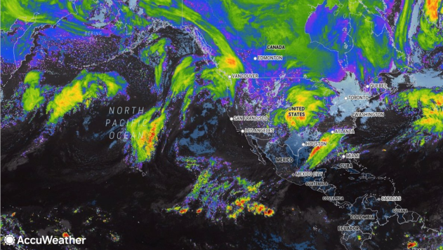
This image of the North Atlantic (right), North America (center) and the northern Pacific Ocean (left) was captured on Monday, Jan. 8, 2024, and shows a long line of storms (bright colors). (AccuWeather Enhanced RealVue™ Satellite). |
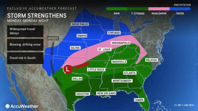
At peak, the storm, from Monday to Tuesday, will sprawl over much of the eastern half of the nation, encompassing more than 30 states.
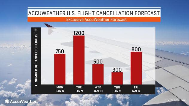
Due to the storm's far-reaching impacts, significant travel delays are likely on the highways. Flight delays and cancellations are likely at the major hubs and smaller regional airports from portions of the southern Plains to the Midwest, South and Northeast. Ripple-effect flight delays and cancellations due to deicing operations, ground stops and displaced crew and aircraft can occur throughout the U.S.
 |
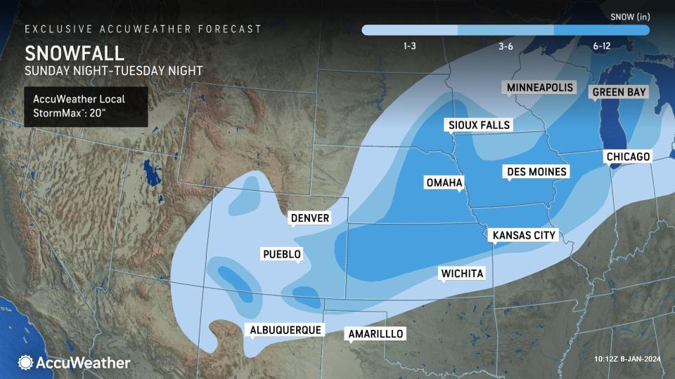
After the storm negotiates the interior West, a long swath of 3-12 inches of snow will extend for about 1,500 miles from the mountains of the Southwest to the upper Great Lakes region during the first couple of days of the week. As the storm's snow shield expands to the northeast, it will cover vast stretches of interstates 25, 40, 70, 80, 35, 29, 55 and 94. Motorists venturing along these highways may have to contend with snow, slush and blowing and drifting snow for hundreds of miles.
 |
The heaviest snow, with 6-12 inches and an AccuWeather Local StormMax™ of 20 inches, will extend from central Kansas to northern Michigan. Portions of the Chicago and Kansas City, Missouri, metro areas will be within part of this heavy snow and highly disruptive travel zone. Other major Midwest cities likely to be within the thick of the heavy snow include Topeka, Kansas; Omaha, Nebraska; Des Moines, Iowa; Madison, Wisconsin; Rockford, Illinois and Milwaukee.
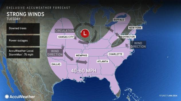
As the storm strengthens within this zone, winds will increase and average 20-40 mph with gusts from 40-60 mph and locally stronger. Winds this strong can lead to sporadic power outages and airline delays where winds blow perpendicular to the runways. Blowing and drifting snow will become a problem in open areas. There is the potential for localized blizzard conditions, where the snow remains or becomes dry and powdery over portions of the central and southern Plains and the Great Lakes region.
 |
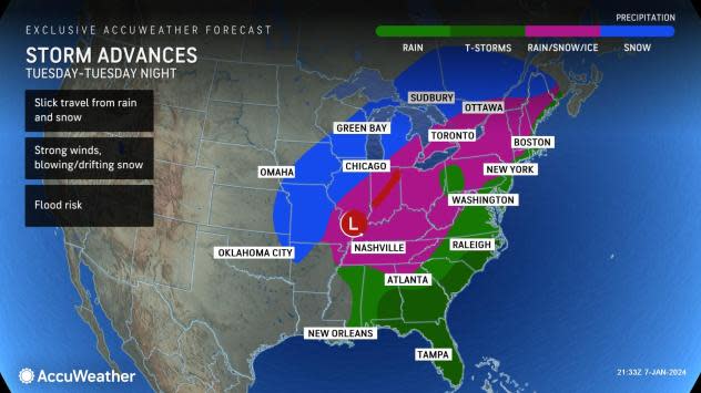
Near and just south and east of the storm track, cold air at the onset and the immediate wake may result in heavy wet snow that changes to drenching rain and then back to snow. This is most likely from portions of central Missouri to central Illinois, northern Indiana, northwestern Ohio and the southeastern part of the Lower Michigan Peninsula. The metro areas of St. Louis and Detroit may fall within this weather battle zone where cold air and warm air exchange hands.
 |
Farther to the south and east, over much of the middle and lower Mississippi Valley and the Ohio Valley, much of the storm's legacy will be drenching rain, increasing winds and even thunderstorms. Enough rain may fall with and without thunder, leading to localized flash flooding.
In portions of the Northeast, where heavy snow from the storm the past weekend is on the ground, surging warm air, heavy rain and strong snow-eating winds will lead to a rapid runoff from Tuesday to Wednesday. Small streams and rivers will be on the rise with the potential for a serious flash flood event.
In the South Central and Southeast states, the rain will benefit drought-stricken areas. However, the risk of flash flooding and the potential for severe thunderstorms in portions of the I-10 to I-20 corridors will also exist from Monday to Tuesday.
 |
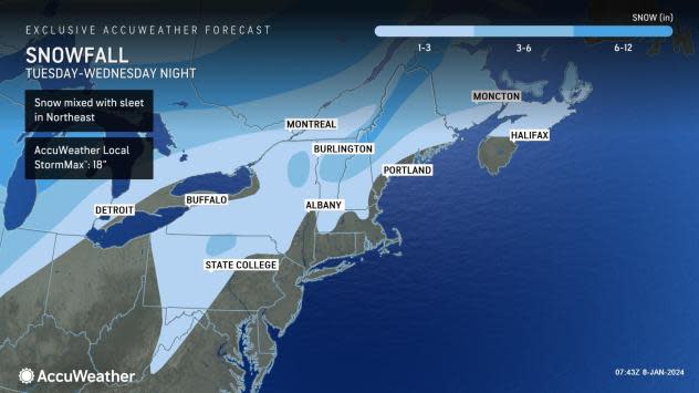
Accumulating snowfall is expected to continue to spread northeastward out of the Plains into the Great Lakes and northern New England from Tuesday to Wednesday night. Forecasters say that a general swath of 1-3 inches of snow can occur across parts of the interior Northeast, while 3-6 inches of snow can accumulate in areas of the Adirondacks, Green and White Mountains into southeastern Canada.
In some Northeast locations, forecasters say snow can mix with sleet at times. The AccuWeather Local StormMax™ for accumulating snowfall across the interior Northeast and upper New England is currently 18 inches.
 |
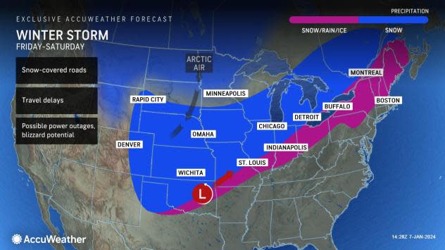
AccuWeather meteorologists continue to monitor the stormy pattern well behind the storm for early next week. Early indications are that Arctic air will surge southward from the Northwest to the North Central states as a new storm rolls in from the Pacific Ocean.
This new storm, slated to hit the middle of the nation during the second weekend of January, could evolve into one of the most intense snowstorms in recent years from parts of the Plains to the Midwest. Depending on the storm's track and strength, travel-stopping and dangerous blizzard conditions may once again unfold over multiple states from Texas to Michigan next weekend.
 |
Updates on the storms for the start of the week and next weekend will be available on AccuWeather's Network, APP, website and many of AccuWeather's local radio, television and newspaper affiliates.
Want next-level safety, ad-free? Unlock advanced, hyperlocal severe weather alerts when you subscribe to Premium+ on the AccuWeather app. AccuWeather Alerts™ are prompted by our expert meteorologists who monitor and analyze dangerous weather risks 24/7 to keep you and your family safer.
