It may get frosty before summer arrives in these parts of Canada
The calendar shows that summer is just a few short weeks away, but that doesn't mean the end of the chilly temperatures.
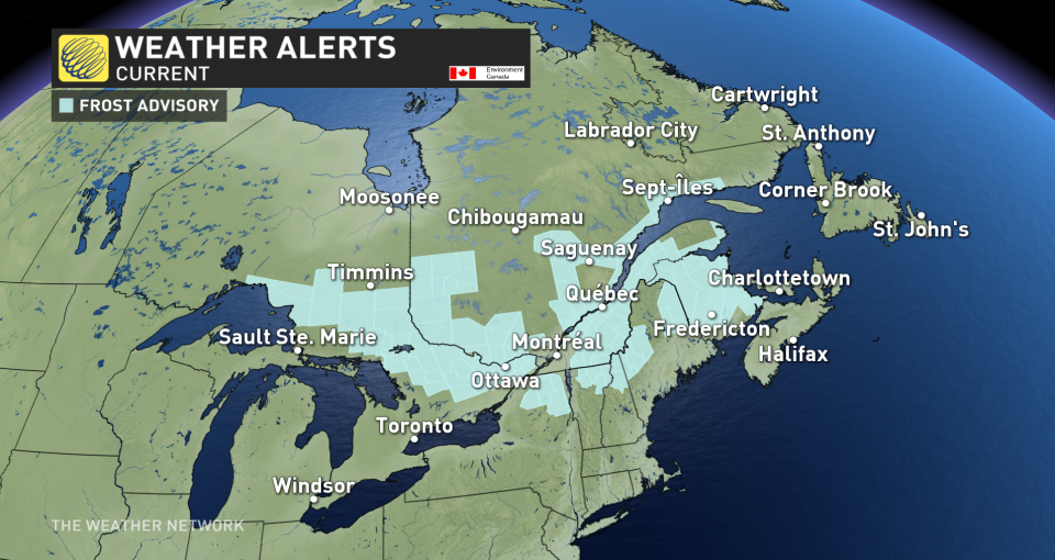
In fact, for parts of Eastern Canada, overnight lows will dip to values that could bring on frost in the next several days. The expected chills have prompted Environment and Climate Change Canada (ECCC) to issue frost advisories across parts of Ontario, Quebec and New Brunswick.
SEE ALSO: What's the temperature 'sweet spot' for swimming in lakes and rivers?
Frost advisories are issued when temperatures are expected to reach the freezing mark during the growing season, leading to potential damage and destruction to plants and crops.
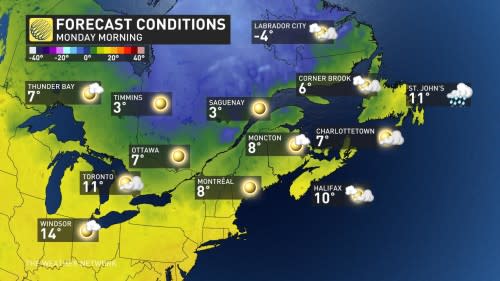
Monday morning
Areas: Eastern Ontario, Quebec and New Brunswick.
Timing: The temperatures will bottom out close to 6 a.m. local time, then the patchy frost will quickly melt. ECCC has frost advisories in place from Wawa, Ont., to Moncton, N.B.
Weather: Clear skies behind a cold front triggers the chilly temperatures
Wednesday to Thursday morning
A heavy frost returns to northeastern Ontario by Wednesday morning as a sharp cold from tracks in.
Another trough gives temperatures near the freezing mark, even across southern Ontario, including Barrie and the Dundalk Highlands, by Thursday morning. Algonquin Park will be a frosty affair, and regions across northeastern Ontario will likely fall below the freezing mark.
Some lingering morning frost for Friday is in the cards across Ontario, Quebec and parts of Atlantic Canada as the trough becomes cut off from the main flow, keeping temperatures seasonably chilly.
Prepare
When you’re driving, pay attention to when your car’s thermometer falling to three degrees or lower, as temperatures near the ground are likely cooler.
Frost may damage some crops in frost-prone areas. Cover up plants, especially those in frost-prone areas.
Storm analysis
After the cold front slides through by Monday, a trough gets left behind in southern Ontario and Quebec. You’ll notice the effects of the trough at the surface by Thursday, pushing temperatures as much as 10 degrees below normal across Quebec, and 5-8 degrees below normal across southern Ontario.
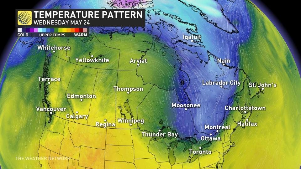
A bizarre temperature reversal is in store for Atlantic Canada, with Newfoundland actually trending above normal on Thursday, while the Maritimes suffer under the trough.
It means parts of Newfoundland will surge close to 20 degrees while other provinces farther west struggle to get much into the double digits for highs.
Stay tuned to The Weather Network for the latest forecast updates for Eastern Canada.
With files from Tyler Hamilton, a meteorologist at The Weather Network.

