May snowfall brings 1 to 3 inches to Appleton, Oshkosh, Green Bay and Door County
It's been spring for a while, at least according to the calendar. But over Monday and Tuesday, many parts of northeastern Wisconsin will be reminded that Wisconsin winter can be stubborn.
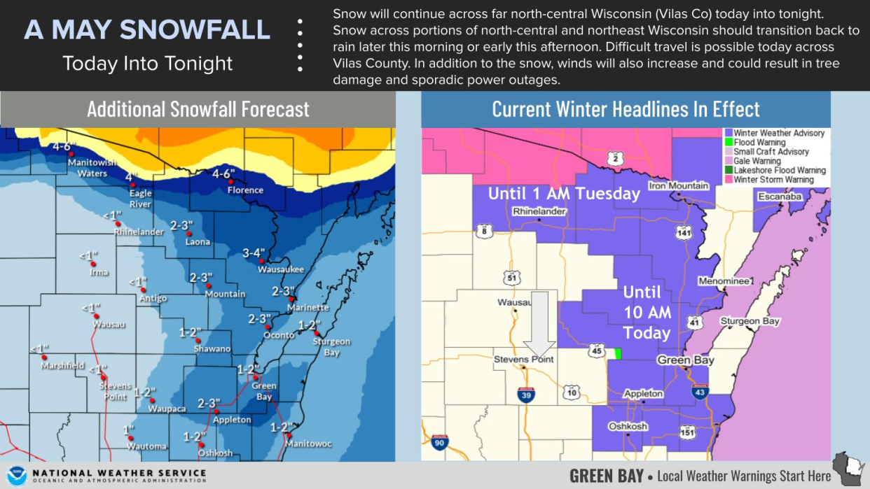
One to three inches of slushy, wet snow is expected Monday for Green Bay, Appleton, Oshkosh, Door County and Oconto, with trace amounts of snow elsewhere and even more snow farther north, according to the National Weather Service.
And while the snow is forecast to wrap up by mid-morning Monday, you'll likely still need your jacket Tuesday as cold temperatures persist across northern Wisconsin.
Here's what we know about this sudden burst of snowy, wet weather.
How much snow will we get?
Central Wisconsin is forecast to see only trace amounts of snow. Further east, Appleton, Green Bay, Oshkosh, Door County, and Oconto could see 1 to 3 inches of snowfall by the end of Monday morning. South of Oshkosh, the snow is expected to get thinner on the ground and slushier.
Further north, along the border between Wisconsin and Michigan, communities like Eagle River, Rhinelander and Ironwood, Mich. are seeing 6 to 8 inches of snow, with potential for 4 to 6 more inches Monday and Tuesday.
How often does it snow in May?
The weather service in Green Bay said in a Facebook post, "Since 1887, Green Bay has recorded measurable snow on 22 days during the month of May. To put it into perspective, that is 22 days out of 4,217 days, or 0.4%."
So a May snowfall is not unheard of, but it is unusual. "Usually, (the city of Green Bay) will get flurries here and there that don't last very long," said meteorologist Timm Uhlmann, "but measurable snow isn't super common."
Uhlmann said the latest May snowfall in Green Bay was recorded May 28, 1947 when 3 inches of snow fell on the city.
What's causing this, and what's next?
A low-pressure system separated itself from the polar jet stream and is now lingering over the Great Lakes, pulling colder air from Canada, Uhlmann said.
These events are common in Wisconsin, and a similar system last week resulted in wet, rainy weather.
"We usually get at least one in the spring and fall," he said.
What's unusual is that this time, he said, temperatures are cold enough for snow.
Because this system has been moving slowly, cold temperatures are expected to persist into Tuesday, according to the NWS. Much of the region is forecast to get highs in the 40s Tuesday with the potential to break records for cold days in May.
Monday is also expected to see wind speeds of up to 40 miles per hour during the afternoon and evening, gradually dying down over Tuesday.
Here's a look at Green Bay weather radar
Can't see the image? Click here.
Rebecca Loroff is a breaking and trending news reporter for USA TODAY NETWORK-Wisconsin. Contact her at rloroff@gannett.com.
This article originally appeared on Appleton Post-Crescent: May snowfall brings 1 to 3 inches to Appleton, Oshkosh, Green Bay and Door County

