McKinney Fire destroys 87 homes; team continues to survey wildfire damage in Siskiyou County
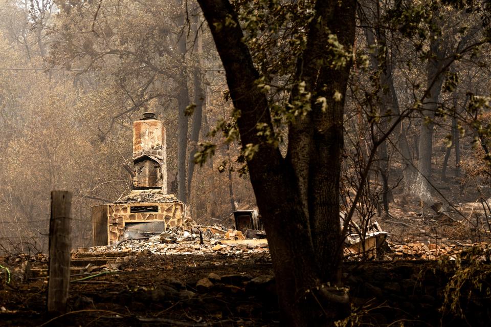
A partial assessment of the damage caused by the McKinney Fire found California's deadliest and largest wildfire of the year has destroyed 87 homes and 45 other buildings.
Four structures sustained minor damages, while 134 other structures were not damaged. The assessment on Friday was more than 50% complete, according to the Siskiyou County Office of Emergency Services.
Four people have died in the fire.
The week-old McKinney Fire was up to 59,636 acres. Friday's size grew by 968 acres from Thursday.
Timber, brush and tall grass that got wet from this week's thunderstorms will continue to dry out as temperatures increase and humidity decreases, Klamath National Forest officials said.
Containment remained at 10% but crews were expected to gain more containment Friday, the officials said.
"The fire remains hot around the entire perimeter with cooling observed in some interior locations," officials said in a statement.
Bulldozers have built contingency lines around much of the fire's boundary to protect at-risk communities in case the firefighters' lines don't hold, the officials said.
However, firefighters again were up against unfavorable weather and potentially gusting winds that could fan the flames.
"Thunderstorms continue to creep into the forecast with isolated cells, potentially creating outflow winds that could produce erratic gusts up to 30 mph," fire officials said.
Mop-up operations are underway in the Walker Bridge area of Klamath River and other communities along Highway 96 from near its junction with Highway 263 to Seiad, east toward Yreka and Scott Bar, and Horse Creek on the west, officials said.
Meanwhile, the Yeti and Alex Fires are a combined 5,036 acres in western Siskiyou County.
The Yeti Fire is burning on the Klamath National Forest between Seiad and Happy Camp, south of Highway 96.
Fire officials say Highway 96 is open through the Yeti Fire area, but is closed east of the fire at the junction of Highways 96 and 3 due to the McKinney blaze.
Crews were able to conduct strategic firing operations along the southeast portions of the Yeti Fire on Thursday along Grider Creek Road to stop the fire’s spread toward Seiad Valley, Klamath National Forest officials said.
Crews working on the fire's southwestern side were preparing for firing operations from the intersection of China Grade, Grider Ridge and Grider Creek roads moving west.
"Firefighters brushed the fire-facing side of the road — removing burnable fuels and stacking them on the opposite side — in order to facilitate a successful burn operation and reduce the fire intensity," fire officials said.
Firefighters also were patrolling the Highway 96 corridor and building contingency lines north of Seiad Valley.
Western Siskiyou County residents can attend a Saturday meeting about the Yeti and Alex fires. The public meeting will be at 7 p.m. Saturday at Happy Camp High School.
In other fire updates:
Meamber Fire: Near Meamber Creek and Scott River roads, northwest of Fort Jones in Siskiyou County, remains at 63 acres and is 85% contained.
Shackleford Fire: Off Shackleford Road and Big Meadows Creek, west of Fort Jones in Siskiyou County, remains at 31 acres and is 95% contained.
Smokey Fire: Firefighters have gotten a handle of the blaze, which started Thursday morning just north of the McKinney Fire about 2 miles south of the Oregon border. The 34-acre fire is off Beaver Creek and Forest Road 48N01, west of Hilt and north of Yreka.
Firefighters working on the McKinney Fire were able to quickly respond to the Smokey Fire and stop its forward spread.
"Firefighters have control line and hose lays completely around it and aircraft continue to be utilized in the area as needed," fire officials said Friday morning.
The cause of that fire is under investigation.
An interactive structure status map from the McKinney Fire is available at Siskiyou County Office of Emergency Services webpage: co.siskiyou.ca.us/emergencyservices.
Michele Chandler and Mike Chapman write for the Redding Record Searchlight/USA Today Network. Follow Michele on Twitter at @MChandler_RS, call her at 530-338-7753 or email her at michele.chandler@redding.com. Email Mike at michael.chapman@redding.com Please support our entire newsroom's commitment to public service journalism by subscribing today.
This article originally appeared on Redding Record Searchlight: McKinney Fire damage: 87 homes destroyed as team continues its survey

