McKinney, Yeti Fire updates: McKinney Fire destroyed 87 homes; new evacuation warnings out
This story is provided free of charge as a public service to our communities. Please support local journalism and subscribe.
9:45 p.m. Friday UPDATE
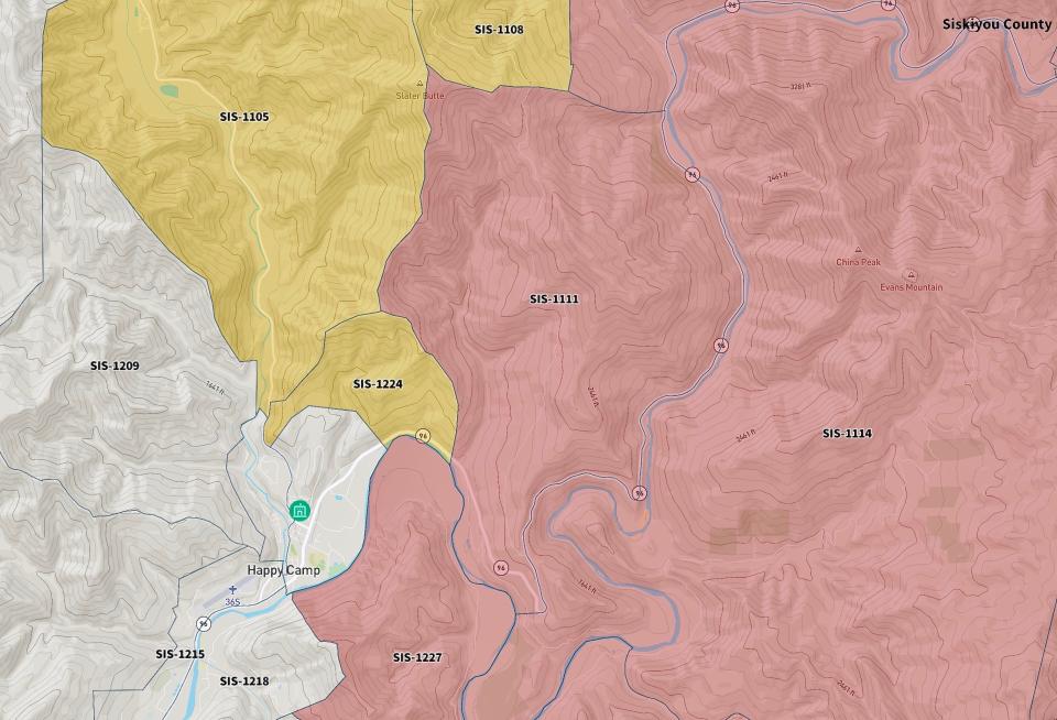
Due to fire activity east of Happy Camp, the Siskiyou County Sheriff’s Office placed the following zones under evacuation warning earlier today:
ZONE SIS-1221
NORTH OF China Grade Road, Indian Creek Road
SOUTH OF Highway 96, Indian Creek Road
EAST OF Indian Creek Road
WEST OF Mill Road
ZONE SIS-1212
NORTH OF Buckhorn Road, Indian Creek Road
SOUTH OF Indian Meadows Drive, Indian Creek Road
EAST OF Buckhorn Road
WEST OF Indian Creek Road
ZONE SIS-1215
NORTH OF Highway 96, Lower Elk Creek Road, FR 17n16
SOUTH OF FR 17n16, Lower Airport Road, Buckhorn Road
EAST OF Lower Elk Creek Road
WEST OF 2nd Avenue, Indian Creek Road
ZONE SIS-1218
NORTH OF Forest Route 15n12
SOUTH OF Highway 96
EAST OF Highway 96
WEST OF Forest Route 45n85, Elk Creek Road
ZONE SIS-1230 A
NORTH OF Cougar Creek
SOUTH OF Forest Route 45n85
EAST OF Highway 96, Lower Elk Creek Road, FR 15n12
WEST OF Forest Route 45n19
2:30 p.m. Friday UPDATE
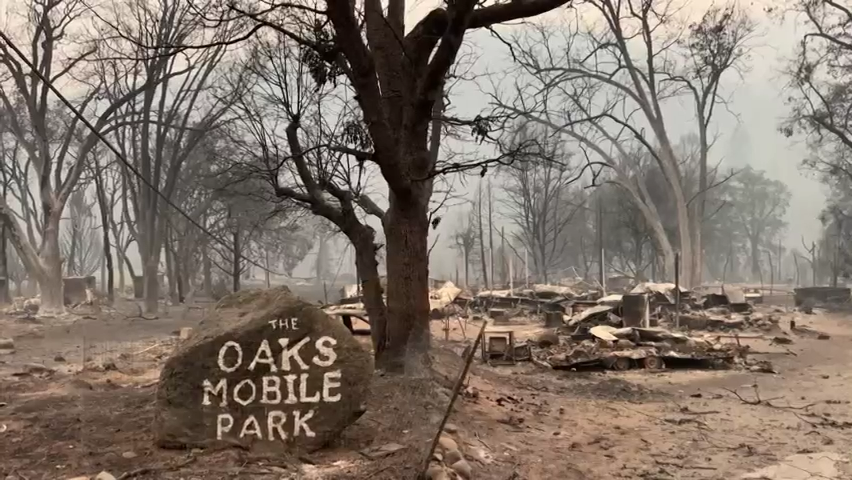
The McKinney Fire has destroyed 87 homes and 45 other structures, fire officials said Friday afternoon.
Another 134 structures were not damaged, while four more sustained minor damage.
Crews have inspected a total of 274 structures so far.
The count represents findings from the initial damage assessment phase, which is more than 50% complete, the Siskiyou County Office of Emergency Services said.
An interactive structure status map is available at Siskiyou County Office of Emergency Services webpage: https://www.co.siskiyou.ca.us/emergencyservices.
9:45 a.m. Friday UPDATE
Western Siskiyou County residents can attend a Saturday meeting about the Yeti and Alex fires.
The public meeting will be at 7 p.m. Saturday at Happy Camp High School.
Fire officials say the Yeti Fire moderated from Thursday night into Friday morning due to cooler temperatures and little wind.
9:30 a.m. Friday UPDATE
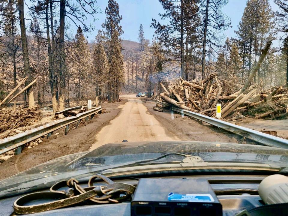
The incident management team in charge of the McKinney Fire says firefighters continue to make "great progress" around the perimeter of the 59,636-acre blaze.
Crews are directly fighting the flames and aggressively digging fire lines, and tying in those control lines with previous lines, officials said.
"Crews continue to get depth on containment lines on the west side of the fire," officials said.
Bulldozers have built contingency lines around much of the fire's boundary to protect at-risk communities in case the firefighters' lines don't hold, the officials said.
However, firefighters again were up against unfavorable weather and potentially gusting winds that could fan the flames.
"Thunderstorms continue to creep into the forecast with isolated cells, potentially creating outflow winds that could produce erratic gusts up to 30 mph," fire officials said.
Mop-up operations are underway in the Walker Bridge area of Klamath River and other communities along Highway 96 from near its junction with Highway 263 to Seiad, east toward Yreka and Scott Bar, and Horse Creek on the west, officials said.
9 a.m. Friday UPDATE
Firefighters have gotten a handle on the Smokey Fire, which started Thursday morning just north of the McKinney Fire about 2 miles south of the Oregon border.
The 34-acre fire is off Beaver Creek and Forest Road 48N01, west of Hilt and north of Yreka.
Firefighters working on the McKinney Fire were able to quickly respond to the Smokey Fire and stop its forward spread.
"Firefighters have control line and hose lays completely around it and aircraft continue to be utilized in the area as needed," fire officials said Friday morning.
The cause of that fire is under investigation.
8 a.m. Friday UPDATE
The week-old McKinney Fire is up to 59,636 acres. The size grew by 968 acres from Thursday.
Timber, brush and tall grass that got wet from this week's thunderstorms will continue to dry out as temperatures increase and humidity decreases, Klamath National Forest officials said.
Containment remained at 10% but crews are expecting to gain more containment Friday, the officials said.
"The fire remains hot around the entire perimeter with cooling observed in some interior locations," officials said in a statement.
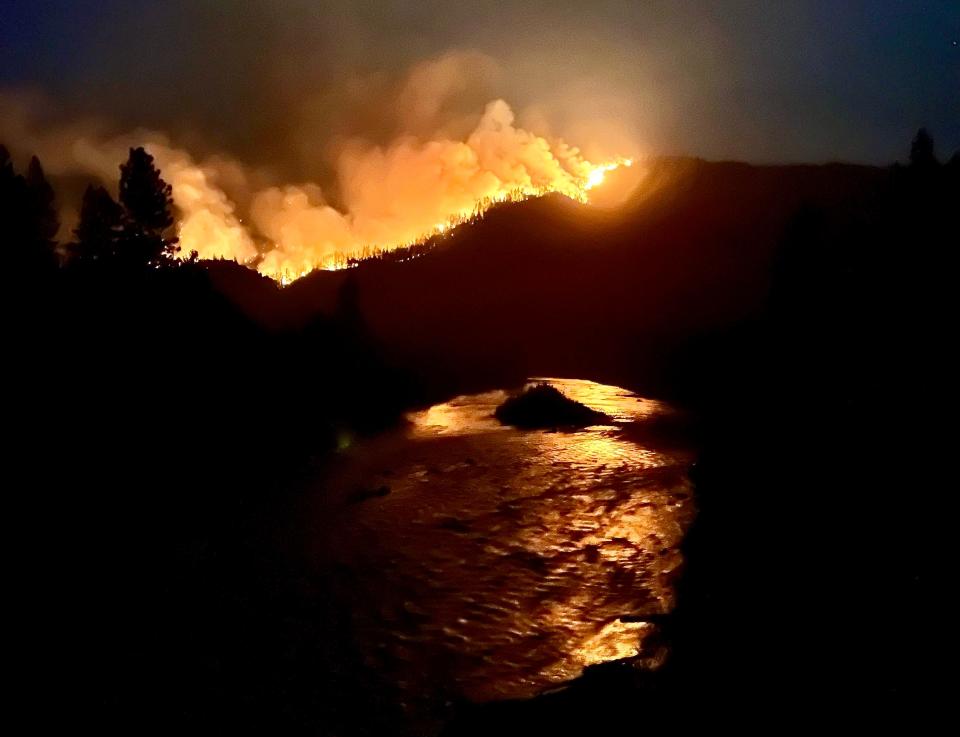
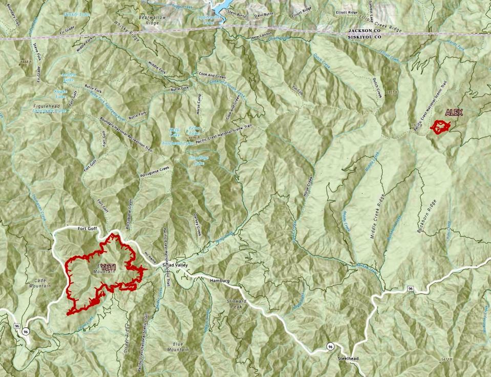
Meanwhile, the Yeti and Alex Fires are a combined 5,036 acres in western Siskiyou County.
The Yeti Fire is burning on the Klamath National Forest between Seiad and Happy Camp, south of Highway 96.
Evacuation orders and warnings are in effect for the Yeti Fire, officials said. For the latest on evacuations, go to https://community.zonehaven.com/.
Fire officials say Highway 96 is open through the Yeti Fire area, but is closed east of the fire at the junction of Highways 96 and 3 due to the McKinney blaze.
Crews were able to conduct strategic firing operations along the southeast portions of the Yeti Fire on Thursday along Grider Creek Road to stop the fire’s spread toward Seiad Valley, Klamath National Forest officials said.
Crews working on the fire's southwestern side were preparing for firing operations from the intersection of China Grade, Grider Ridge and Grider Creek roads moving west.
"Firefighters brushed the fire-facing side of the road — removing burnable fuels and stacking them on the opposite side — in order to facilitate a successful burn operation and reduce the fire intensity," fire officials said.
Firefighters also were patrolling the Highway 96 corridor and building contingency lines north of Seiad Valley.
In other fire updates:
Meamber Fire: Near Meamber Creek and Scott River roads, northwest of Fort Jones in Siskiyou County, remains at 63 acres and is 85% contained.
Shackleford Fire: Off Shackleford Road and Big Meadows Creek, west of Fort Jones in Siskiyou County, remains at 31 acres and is 95% contained.
6 a.m. Friday UPDATE:
Siskiyou County, already under siege from the McKinney Fire, is dealing with a new threat — the lightning-caused Yeti and Alex Fire Complex burning in western Siskiyou County. Threats from those fires prompted Sheriff Jeremiah LaRue to order residents in the Happy Camp area to evacuate on Thursday.
There's also a fresh fire for the county fire crews and area residents to contend with.
The Smokey Fire ignited Thursday morning off Beaver Creek and Forest Road 48N01, west of Hilt in Siskiyou County.
The Yeti Fire sits between Happy Camp and Seiad Valley, west of the McKinney Fire, while the Alex Fire is closer to the Oregon border.
A comprehensive assessment of buildings damaged by the McKinney Fire got underway on Thursday, the Siskiyou County Sheriff's Office said. About 50 volunteer search and rescue members are participating.
Members of search and rescue teams are expected to check more than 200 structures over the next few days in areas that have burned, said Siskiyou County Sheriff Jeremiah LaRue.
"We are checking to see if anybody is deceased," he said, while county officials are performing damage inspections to determine if it is safe for people to return to their homes.
So far the McKinney Fire has burned through 58,668 acres as of Thursday night, with 10% containment, fire officials said. That's up from 57,519 acres on Wednesday.
Four people have lost their lives in the wildfire, which leveled the small town of Klamath River. All told, more than 3,000 people have been displaced. Some residents have been able to return to their homes as conditions have improved.
After some recent rains, the weekend weather outlook calls for mostly sunny, hot, dry, and breezy weather through Sunday. Temperatures are expected to range from 95 to 105 degrees, with minimal humidity and light winds.
After several areas in Yreka and Hawkinsville were downgraded from evacuation orders to evacuation warnings, some residents have been able to return to their homes.
A local assistance center containing critical government services for residents who have been impacted by the fire is expected to open soon.
Fire officials stressed the situation still remains unsettled and have urged residents to stay vigilant and ready to quickly evacuate if necessary.
8:32 p.m. Thursday UPDATE
A community meeting for people impacted by the McKinney and Yeti fires will be held at the Siskiyou Golden Fair grounds in Yreka on Aug. 5 at 7 p.m., the Siskiyou County Sheriff's Office said.
The meeting will take place at 1712 Fairlane Rd. in Building One, on the left through the main gate.
Questions can be sent ahead of time to 2022.McKinney@firenet.gov.
The meeting can also be accessed on the following platforms:
YouTube at bit.ly/McKinneyFireYouTube
12:45 p.m. Thursday UPDATE
Mandatory evacuation orders have been issued by the Siskiyou County Sheriff's Office for fire activity east of Happy Camp due to the Yeti Fire.
"This area is being evacuated due to proximity to the fire. Residents in the evacuation order area should evacuate immediately," fire officials said.
Go to https://bit.ly/3QbjsHE for the map. Here are the zones:
MANDATORY EVACUATION ORDERS:
𝗭𝗼𝗻𝗲 𝗦𝗜𝗦-𝟭𝟭𝟭𝟭
North of Gordons Ferry Road, Highway 96
South of Forest Route 19n01
East of Forest Route 19n01, Highway 96
West of Highway 96
𝗭𝗼𝗻𝗲 𝗦𝗜𝗦-𝟭𝟮𝟮𝟳
North of Forest Route 45n85
South of California Highway 96, China Grade Road
East of Elk Creek Road
West of Forest Route 45n85, China Grade Road
NEW EVACUATION WARNING:
𝗭𝗼𝗻𝗲 𝗦𝗜𝗦-𝟭𝟮𝟮𝟰
North of Highway 96
South of Highway 96
East of Indian Creek Road
West of Highway 96
A temporary evacuation point is being set up at the Karuk Tribal Wellness Center, 627 Jacobs Way, in Happy Camp. For questions, call 530-598-5593.
Also, the shelter at Weed Community Center is closing and being relocated to Yreka to the Kahtishraam Wellness Center located at 1403 Kahtrishraam.
In another development, the Siskiyou County Office of Emergency Services says there's a Verizon outage in the fire area and gave instructions for using 911.
"We are aware of the outage. If you are a Verizon customer, you can still call 9-1-1 if you have an emergency. 9-1-1 continues to work even when your cell phone does not have reception. You can also turn on Wi-Fi calling if you have access to Wi-Fi," OES officials said. "Please only call 9-1-1 if you have a true emergency."
Also, a fresh fire called the Smokey Fire started Thursday morning off Beaver Creek and Forest Road 48N01, west of Hilt in Siskiyou County.
Animal sheltering is available for:
Dogs at 2216 East Oberlin Road in Yreka, 530-842-0829
Cats at 200 S. 11th St. in Montague, 541-531-1086
Livestock at 1712 Fairlane Road in Yreka (access from Sharps Road at horse barns), 530-340-1038
All found animals (with no known owner) within the evacuation zone will be posted at: https://www.co.siskiyou.ca.us/animalcontrol/page/mckinney-fire-lost-found-animals
The evacuation zone map can be accessed on Zone Haven at community.zonehaven.com.
11:30 a.m. Thursday UPDATE
Also burning in western Siskiyou County are the lightning-caused Yeti and Alex fires.
The Yeti Fire is between Happy Camp and Seiad Valley, west of the McKinney Fire, while the Alex Fire is closer to the Oregon border.
The Yeti Fire was 4,626 acres while the Alex Fire was 151 acres, according to a Klamath National Forest update. The fires are threatening 336 structures and have 0% containment as of Thursday morning.
About 800 personnel are assigned to both fires, amounting to 16 crews, 48 engines, five dozers, 14 water tenders and seven helicopters.
Motorists on Highway 96 can expect to see trees burning in the Yeti Fire, officials said.
"While activity in this area picked up Wednesday, crews are along the highway to catch any embers that try to push the fire over the river," officials said.
Crews are building primary fire lines but also constructing secondary lines to protect the communities of Seiad and Happy Camp.
9:30 a.m. Thursday UPDATE
Another community meeting is planned for Friday night at the Siskiyou Golden Fair grounds in Yreka.
Fire officials say details on the time and specific location will be announced shortly.
Questions can be sent in advance to 2022.mckinney@firenet.gov.
In a McKinney Fire update, officials said Tuesday's thunderstorms dropped between 1 to 3 inches of rain on the eastern flank of the blaze with the higher amounts falling on the eastern one-third.
The western half of the fire didn't get any measurable precipitation.
On Wednesday morning, heavy equipment started clearing debris and mud in multiple drainages from flooding that blocked the lower-lying portions of Humbug Creek Road so access could be restored for firefighters.
Many pockets of heat remain despite the rainfall, officials said, and they warn that fire activity on the east side is expected to pick back up.
Pipeline Gap in the northwest has a high potential for the fire to spread. Another active area is near Mill Creek Road in the southwest portion, officials said.
Air tankers and helicopters flew Wednesday to help firefighters limit the fire's spread in those two areas.
8:40 a.m. Thursday UPDATE
A comprehensive assessment of buildings damaged by the McKinney Fire will get underway today, the Siskiyou County Sheriff's Office said.
About 50 volunteer search and rescue members will participate.

"Our crews are still working diligently to do a thorough assessment of structures damaged by the fire," the sheriff's office said.
Meanwhile, the Yeti and Alex Fire Complex has grown to 4,626 acres with 0% containment.
8:15 a.m. Thursday UPDATE
The McKinney Fire grew to 58,668 acres overnight, according to an update by the California Department of Forestry and Fire Protection..
The new size represents an increase of 1,149 acres from Wednesday.
6 a.m. Thursday UPDATE
About 3,000 people have been displaced by the McKinney Fire, which saw containment rise on Wednesday for the first time since the fire started on Friday afternoon.
The fire has so far burned through 57,519 acres, fire officials said at a community meeting held in the town of Fort Jones on Wednesday night. Containment had reached 10% by Wednesday, officials said.
Smoke is expected to linger in the Yreka area for the next several days as the fire continues to burn, smoke analyst John Iiames said at the meeting, which drew dozens of people.
"We will get smoke because it's too big a fire, it will not dissipate," said Iiames. "We're not going to get winds from the north for a while. It will just kind of sit and then come on down" over communities impacted by the wildfire, he said.
While thunderstorms and heavy rain doused portions of the fire on Tuesday — and unleashed severe flash flooding and destructive flows of mud and debris in some areas — the McKinney Fire continues to burn.
Dennis Burns, a fire behavior analyst who helps model where the fire is likely to head next, said the majority of the wildfire area received less than one-tenth of an inch of rain this week. So the fire is still alive and producing smoke.
"We would've been better off to have one inch of rain over three days than the three inches of rain that we got in one hour yesterday," Burns said at the community meeting. "All it did was it gave us a pause."
A rain-damaged bridge led to one firefighter being injured, Klamath National Forest Supervisor Rachel Smith said in a Facebook post. The firefighter received treatment at Fairchild Medical Center and was released late Tuesday night, she said.
Members of search and rescue teams are expected to check more than 200 structures over the next few days in areas that have burned, said Siskiyou County Sheriff Jeremiah LaRue.
"We are checking to see if anybody is deceased," he said, while county officials are performing damage inspections to determine if it is safe for people to return to their homes.
Four people have lost their lives in the wildfire, which leveled the small town of Klamath River.
Wednesday also brought some positives.
After several areas in Yreka and Hawkinsville were downgraded from evacuation orders to evacuation warnings, some residents could return to their homes, the Siskiyou County Office of Emergency Services said.
As of Wednesday night, 17 people remained in a shelter in Weed, down from 59 on Tuesday, Siskiyou County Office of Emergency Services Director Bryan Schenone said.
A local assistance center containing critical government services for residents who have been impacted by the fire will be opening in the next day or so, Schenone said.
Officials stressed the situation still remains unsettled and urged residents to stay vigilant and ready to quickly evacuate if necessary.
"This is sleeping giant right now," said Darryl Laws, unified incident commander with the California Department of Forestry and Fire Protection. About 2,200 firefighters are working on the blaze, said Laws.
While the McKinney Fire's cause remains under investigation, Smith said earlier this week that it was "clear this fire was not caused by lightning."
A specialized U.S. Forest Service team is on site trying to identify a cause for the wildfire, Smith said.
Michele Chandler covers criminal justice issues for the Redding Record Searchlight/USA Today Network. Follow her on Twitter at @MChandler_RS, call her at 530-338-7753 or email her at michele.chandler@redding.com. Please support our entire newsroom's commitment to public service journalism by subscribing today.
This article originally appeared on Redding Record Searchlight: McKinney, Yeti Fires: McKinney Fire has destroyed 87 residences

