Metro-east gearing up for potentially severe weather Friday. Here’s the latest forecast
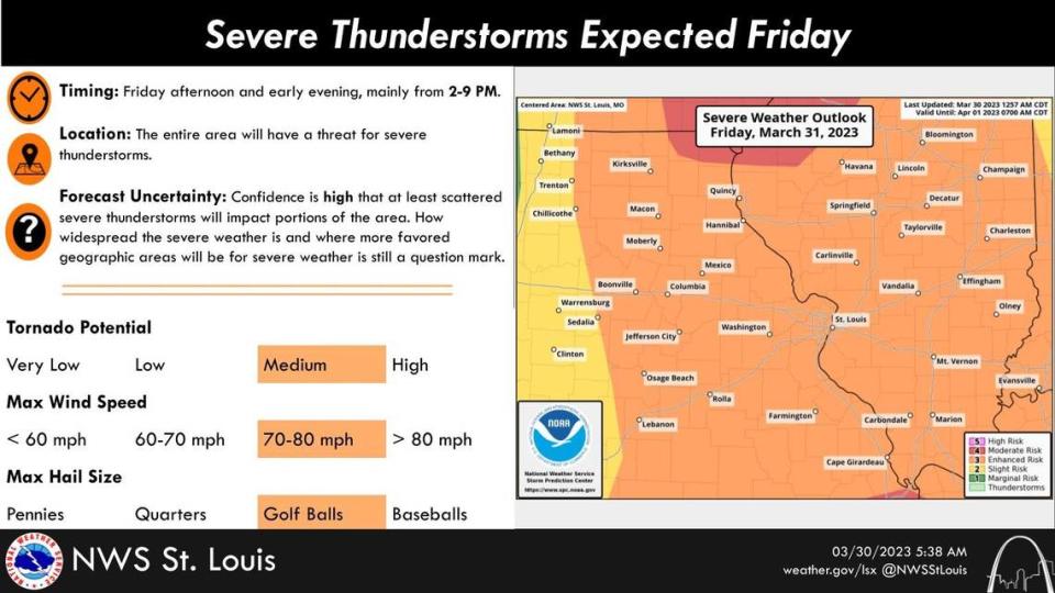
The metro-east remains in the crosshairs of potentially severe weather Friday.
Jared Maples, a meteorologist with the National Weather Service of St. Louis, said Thursday morning a strong line of storms will move into the area around 7 p.m. Friday that could produce hail and possibly tornadoes, to go along with high winds.
“It looks like we’re going to have a cold front entering central Missouri early Friday afternoon with showers and thunderstorms developing and projecting east forming into an elongated line,” he said. “They’ll be moving at a pretty fast clip — 60-65 miles per hour and even slightly higher speeds in some areas. Typically, the speeds are more around 40-50 mph.”
“What typically happens in storms like these is that hail becomes less of a threat. Wind becomes the main threat and tornadoes embedded in the line of storms are still a threat. Winds could reach 70 miles per hour or more.”
Maples said some pockets of rain could materialize before the main event and, if so, those would be isolated.
He then added, at this point, tornado formation remains a secondary threat, noting EF-0 or EF-1 tornadoes that quickly spin up and die out are possible. However, if the combination of the violent air associated with the storm and the wind on the ground reaches maximum potential, then Maples said the potential exists for larger-scale tornadoes to develop.
“In this case, with the model and development and how it’ll evolve, there’s a pretty good chance an EF-0 or EF-1 tornado would pop out along these line of storms,” he said. “Somewhere along that line you’ll have some circulation that’ll spin up or be embedded in the storm. That leads into the question of does it tap into the environment to where storms will produce tornadoes that’ll touch the ground?
“That’s where we’ll have to wait to see. The conditions are primed for it. Once they develop, how long do they stay on the ground and do damage? Are they sustained? That’s where the caveat lies. It’s really hard to pinpoint there. The indications are it could happen. Just the statistics and climatology involved, there’s a pretty good chance of something on the low end developing.”
Maples offered this additional tornado information.
“For higher tornadoes, such as an EF-3, the potential for them to develop drops off because they’re so rare,” he said. “To get a strongly rated tornado you have to have something for it to damage and for it to hit something. The Central Plains can have some nice, organized, strong super cells, and they produce large tornadoes but don’t hit anything so they’re not rated. But then something that’s only 100 yards wide but passed through a densely populated area and caused a lot of damage, it’s an EF-3.”
All in all, Maples said Friday’s storm will be fast moving and out of the area likely within an hour, with some lingering showers possible.
“The line itself will probably be around an hour long, maybe even shorter with the speed it’s trucking at,” he said. “Behind that, we’ll get some pretty gusty winds of 40-50 miles per hour into Saturday.”
The metro-east is under a wind advisory from 1 p.m. Friday to 1 p.m. Saturday.
Flash flooding, power outages, downed trees
Since Maples expects the storm to move quickly, he’s not particularly concerned about flash flooding. He said rain totals likely would be around a quarter inch to a half inch.
“With the speed of the storm, it’s not going to have a lot of residence time over one area,” he said. “Within the storm itself, it’s going to look ominous and come down fast and heavy but not last long.”
Power outages and downed trees, however, are threats.
“Any time you have winds of this magnitude, power outages are a concern ... even with the wind behind the storm into Saturday,” Maples said. “Some of the flowering trees are starting to have some signs of life ... they could suffer some damage. With this set up wind will be a real problem.”
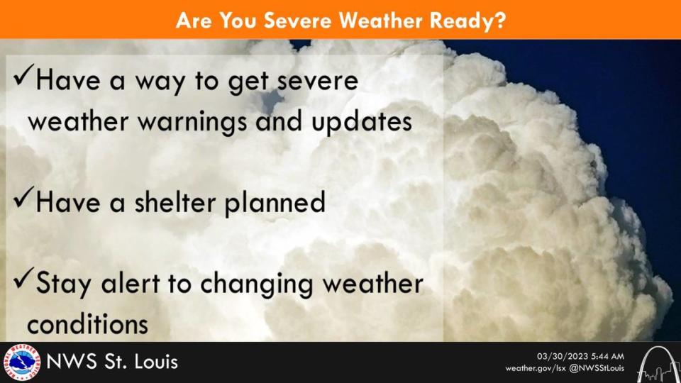
Safety tips
Earlier this week, Brad Charboneau, also an NWS meteorologist, recommended people review their severe weather action plan ahead of Friday’s storm and, if feasible, actually practice these drills.
“Think about where you’ll go and what you’ll do if there’s a severe thunderstorm and you’re at home or at work — and if there’s a tornado warning, where you’ll go,” he said Tuesday. “If you have time, go through your severe weather drill and practice where you can go to keep safe through a thunderstorm or tornado warning. That’s really the best thing you can do. Even if we don’t have severe weather on the horizon this is a good time to do it.”
Maples offered related safety tips, especially for people without basements. Moreover, he suggested having a plan in place prior to the storm to take up shelter with a nearby neighbor or family member who does have a basement.
“Talk to neighbors you might have a rapport with or family or friends and try to get a plan set in place before the event comes,” Maples said. “Say to them, ‘If I need shelter can I come to your place and seek shelter and spend time at your house while the storms go through?’ The first step is to get agreement. Then, keep an eye on the weather and updates and a best estimate of when things will impact your location within a couple hours. Keep an eye on the warnings and watches.
“That way when it starts to bear down, you can make a quick decision. If you’re driving to get shelter, just spend a few hours at that person’s location. That way you don’t have to make that decision and be in a car and in a worse spot out in it rather than already being in a safe structure.”
Additional suggestion, final piece of advice
For people who do not have this option, Maples offered these tips.
“If you can’t get to someone else’s home, then determine the innermost portion of the house such as a hallway closet or a bathroom. These are typically smaller rooms usually enclosed with strong structural materials,” Maples said. “That compact caging often is what helps keep that enclosure in one piece.
“Bathtubs are a huge advantage because they’re basically a shell. Put a mattress or soft pillows over you to shield yourself from outside debris hitting you.”
Whatever a person’s disposition, Maples strongly recommended being proactive instead of reactive.
“Some people may think having a plan in place is overblown. However, talk to people who maybe thought it was overblown in the beginning but had that plan in place to where it was second nature ... instead of having to think about it and not having those extra seconds which could be the difference between being injured or killed.”
The National Weather Service recommends keeping plugged into the forecast as it develops at www.weather.gov. Their Facebook page is www.facebook.com/NWSStLouis.

