Heat advisory issued as South Florida prepares to break temperature records
If Thursday felt unbearably hot in South Florida, Friday has turned the broiler up a notch.
The National Weather Service in Miami issued a heat advisory that runs from noon to 8 p.m. Friday to warn of heat index values that will make temperatures feel 109 degrees.
The worst of it — unless you love to scorch — will be felt in inland, coastal and metro Miami-Dade, Broward and Palm Beach counties and also in far South Miami-Dade, like Homestead and Florida City.
The hot temperatures along with high humidity could cause heat illnesses, the weather service said.
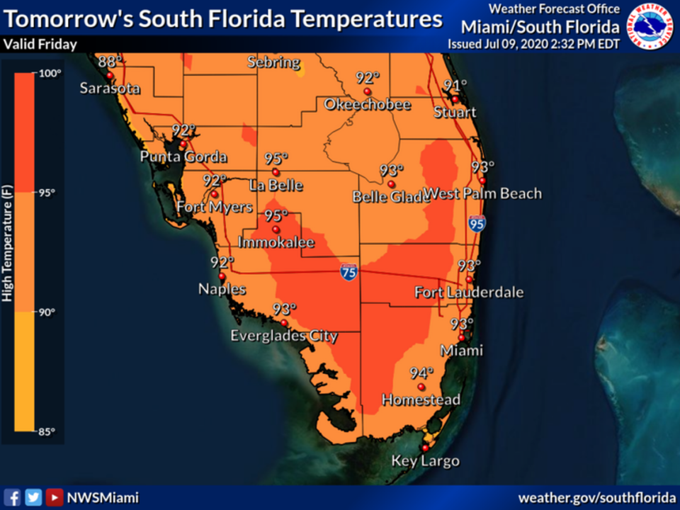
The high Friday is expected to be 92 degrees and it was already 90 by 11 a.m. in Kendall.
The hot spell that broke heat records in Miami and Fort Lauderdale on Thursday will stick around in the weekend and linger early into next week, too.
Heat records set
The National Weather Service recorded 96 degrees in Miami and 98 degrees in Fort Lauderdale around 4:15 p.m on Thursday — record temperatures that the cities hadn’t seen since 1995 and 1963, respectively.
But in most of South Florida, temperatures Thursday afternoon felt up to 10 degrees hotter, according to the weather service’s heat indexes, which factor in humidity with the actual air temperature.
Forecasters said Friday will look very similar to Thursday, with high temperatures across the area in the mid 90s and storms in the late afternoon.
The weekend and early next week are also expected to be hot and wet, with temperatures Saturday through Wednesday hovering in the lower 90s along the coast and reaching the mid to upper 90s in the interior area, according to the NWS.
Heat indexes could reach 109 degrees in some hot spots, forecasters said.
“Generally, during the hotter spells of the summer, we see the index between 100 and 105. But we are stuck in a pattern that promotes the warmer temperatures,” said Sean Miller, an NWS meteorologist. “The strong sea breezes are coming in later and, as a result, we are heating up faster.”
Tips on staying safe during heat waves
As highs soar to the 90s and it will feel like the 100s this afternoon, here are some HEAT SAFETY TIPS: Stay hydrated. Limit outdoor activity. Take frequent breaks if you need to be outside. Never leave children or pets in unattended vehicles. #LookBeforeYouLock @CBSMiami #CBS4 pic.twitter.com/EFf4ApeqXT
— Lissette Gonzalez (@LissetteCBS4) July 10, 2020
The National Weather Service suggests:
▪ Drinking plenty of fluids.
▪ Stay in an air-conditioned room and out of the sun, if possible.
▪ Check up on relatives and your neighbors to make sure they are OK. (If venturing out do so, remember you are supposed to wear a mask in Miami-Dade and Broward given the surging COVID-19 cases.)
▪ Young children and pets should never be left unattended in vehicles. Pets and animals left outside, like dogs and cats, can suffer from heat stroke, too.
▪ Reschedule strenuous activities outdoors, such as work or exercise, to early morning or evening hours if you can — and wear lightweight and loose fitting clothing.
▪ If you are overcome by the heat get to a cool and shaded location.
“Heat stroke is an emergency. Call 911,” the weather service says if you, or someone you see, is suffering from symptoms of heat stroke. According to the Mayo Clinic, these symptoms could include nausea, flushed skin, high body temperature or altered mental behavior.
Rain on the way
Reduced humidity overnight should offer a break from the heat, with temperatures in the mid to upper 70s across most of the area and in the lower 80s along the east coast.
Expect “a wet and unsettled pattern” with heavy rainfall, frequent lightning and locally strong wind gusts every afternoon Friday through Wednesday, forecasters said.
The storms are caused by low pressures over the Gulf and Atlantic waters, according to the weather service.
Miami-Dade County will see a 70 percent chance of afternoon rain on Saturday and likely thunderstorms on the coast on Sunday, while in Broward on Sunday will be cloudy with a 30 percent chance of rain on the coast and a 60 percent chance in the metro area.
Forecasters warn that the storms could cause localized flooding, mostly around the east coast metro area. Small hail, waterspouts and damaging wind gusts could also develop with some of the larger storms.

