When will Miami and Fort Lauderdale see the nastiest weather? What the forecasters say
Updated: This story has been updated to include Wednesday’s weather warnings which, in the Miami and Fort Lauderdale areas could include severe thunderstorms. These storms could include golf ball-sized hail, heavy downpours and wind gusts of 60 mph, according to the National Weather Service in Miami.
Unsettled weather could make your Tuesday miserable in Miami-Dade and Broward.
Strong to severe storms are possible Tuesday, with some lingering storms possible Wednesday, according to CBS News Miami meteorologist Lissette Gonzalez.
What will the strongest storms bring?
Alert day today and tomorrow! The rain chance is highest today and stays high tomorrow for your Wednesday. Thursday the rain chance decreases. But scattered storms possible late week into weekend. @CBSMiami pic.twitter.com/3TZDPtJVfF
— Lissette Gonzalez (@LissetteCBS4) April 25, 2023
“We could see damaging wind, hail, lightning heavy rain that could lead to flooding tomorrow — yet another alert day as we remain unsettled with the potential for more storms,” Gonzalez said in her Tuesday weather broadcast.
According to the National Weather Service in Miami’s hazardous weather outlook, Tuesday’s scattered to numerous thunderstorms over the eastern half of South Florida could feature wind gusts to 60 mph within its gusty winds. The hail could be half-dollar sized. A brief tornado or two is possible, as are several tornadic waterspouts over the Atlantic waters and Lake Okeechobee region through Tuesday.
When will the worst weather arrive?
Unsettled weather continues across South Florida, as numerous showers and thunderstorms may develop this afternoon. Warm temperatures in the low to mid 80s can be expected today, while mild overnight temperatures range from the mid 60s to lower 70s. #FLwx pic.twitter.com/B0sy5bqrdL
— NWS Miami (@NWSMiami) April 25, 2023
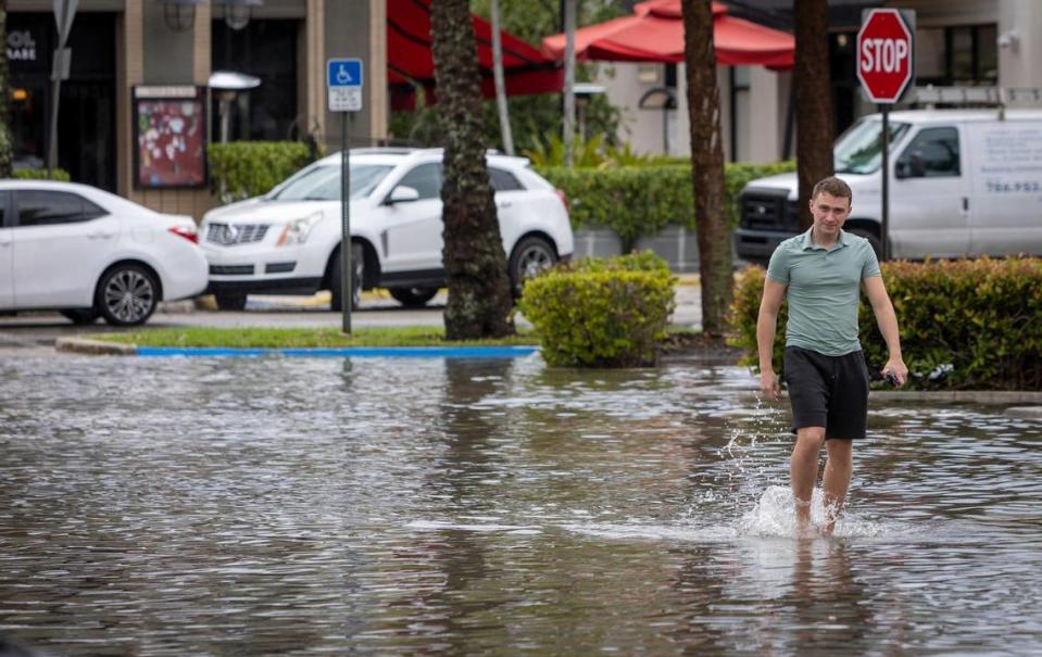
Some rounds of rain already teased parts of Aventura, Hallandale Beach, Sunrise and Weston Tuesday morning, Gonzalez said. “The timing for the worst weather is likely between 2 to 8 p.m.,” she said about the 70% chance of rain.
Aventura had a taste on Monday with reports of flooded streets and some disabled cars around Northeast 188th Street, about a mile south of the mall, the Miami Herald reported.
The weather week forecast
Scattered to numerous thunderstorms are still in the forecast through Friday in South Florida and the Keys, the weather service said.
“Thursday’s looking a little quieter, not as wet, then Friday into the weekend we’ll see the potential for passing storms with a high near 90 Saturday,” Gonzalez said.
The chance of these storms, which, like Tuesday’s could be strong to severe with heavy rain, hail and gusty winds, according to the weather service.
After Tuesday’s 60% chance in the Florida Keys, the storm chances are possible but not as likely as in South Florida, according to the National Weather Service in Key West.
MIAMI-DADE:
▪ Wednesday, 50%. Severe thunderstorms with golf ball-sized hail possible and 60 mph gusts. Funnel cloud or brief tornado possible within the thunderstorms.
4/26 - Heads up, South Florida! Strong to severe thunderstorms will be possible this afternoon and evening. Severe hail, wind gusts and localized flooding will be the biggest hazards through tonight. Stay weather aware and make sure you have a way to receive warnings!#flwx pic.twitter.com/3s9i2ULzQu
— NWS Miami (@NWSMiami) April 26, 2023
▪ Thursday, 20%.
▪ Friday, 20%.
▪ Saturday, 30%.
▪ Sunday, 40%
▪ Monday, 30%.
FORT LAUDERDALE:

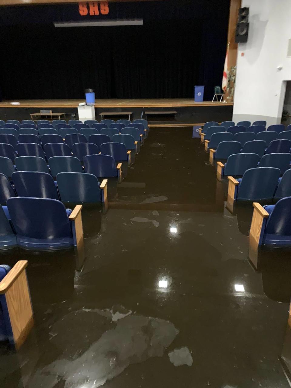
Fort Lauderdale is a region that does not want to hear about coming rains after that April 12 “1-in-1,000-year” storm caused all sorts of lingering problems statewide. Problems included a closed airport, flooded homes and destroyed cars that are still in need of repairs or replacements, $10 million in flood damage to Broward schools and lingering problems (but improving) with gas stations running dry.
KNOW MORE: Fort Lauderdale floods highlight climate risks to South Florida’s airports, seaports
▪ Wednesday, 60%. Severe thunderstorms are possible.
▪ Thursday, 20%.
▪ Friday, 30%.
▪ Saturday, 30%.
▪ Sunday, 40%
▪ Monday, 20%.
FLORIDA KEYS:
The mid-week forecast for #FloridaKeys is below. Dry mid-lvl air after yesterday's rain will keep weather possibly quiet until Fri. High-lvl troughs will bring increased moisture on Friday and a possible cold front by Sun/Mon.#flwx #flkeys #marathonflorida #keywest #keylargo pic.twitter.com/7GDsFMkqlV
— NWS Key West (@NWSKeyWest) April 26, 2023
▪ Wednesday, 10%.
▪ Thursday, 10%.
▪ Friday, 20%.
▪ Saturday, 20%.
▪ Sunday, 30%
▪ Monday, 20%.
Record daily high amounts of moisture in the environment, a weak surface trough, and turning winds allowed heavy rain to develop over the Lower and Mid #FloridaKeys this morning. Showers will dissipate later in the afternoon.
#flkeys #flwx #marathonflorida #keylargo #keywest pic.twitter.com/S0qyv7okXU— NWS Key West (@NWSKeyWest) April 25, 2023
Temperature highs in the mid- to upper-80s, lows about 10 degrees cooler in the mid- to upper 70s through the week in South Florida, the weather service said.
Rip currents
Look for the risk of rip currents at Atlantic beaches to rise mid-week, especially in coastal Palm Beach where the risk will be higher.

