Middle Tennessee weather: Freezing rain expected overnight Monday into Tuesday

Looking for the latest Tuesday weather updates? Find them here.
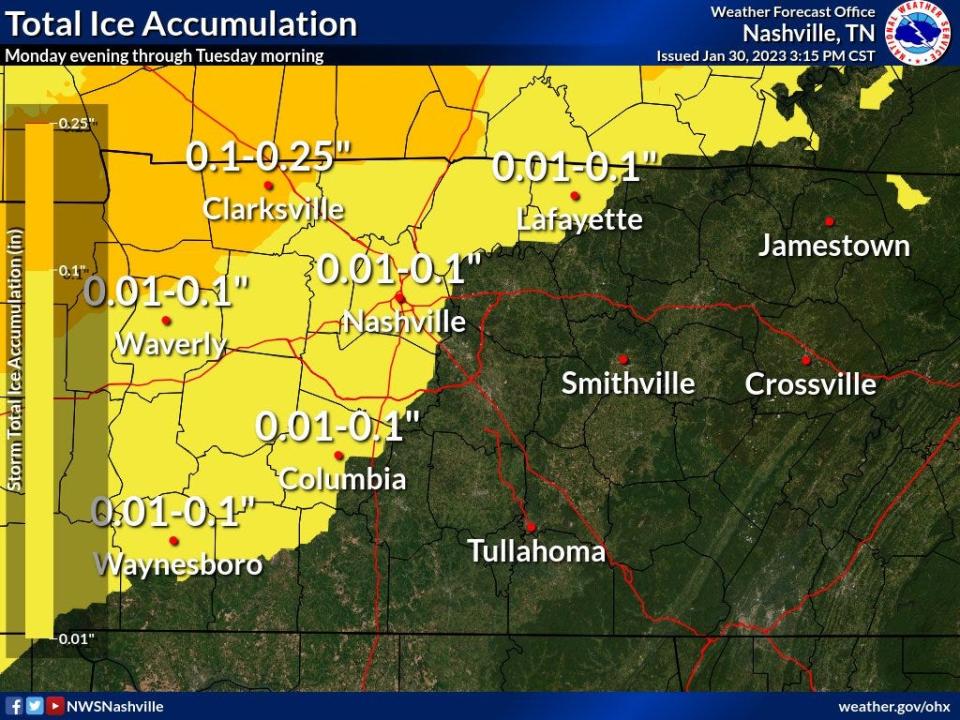
The first of two rounds of freezing rain is possible across Middle Tennessee starting tonight through noon Tuesday, the National Weather Service Nashville said.
A winter weather advisory takes effect for the northwest part of the region at 9 p.m. Monday and is set to run through 12 p.m. Tuesday. Accumulation could range from 0.01 to 0.1 inches by Tuesday morning, the forecast showed.
"The hazardous conditions could impact morning commute Tuesday morning," NWS Nashville said. "Slow down and use caution while traveling."
The counties included in the advisory are: Cheatham; Davidson; Dickson; Hickman; Houston; Humphreys; Lewis; Macon; Maury; Montgomery; Perry; Robertson; Stewart; Sumner; Trousdale; Wayne; and Williamson.
The latest road conditions can be obtained by calling 511. The Tennessee Department of Transportation also has live traffic cameras via its SmartWay traffic maps at smartway.tn.gov/traffic.
Forecast: Another round of freezing rain, ice possible Tuesday night in Middle Tennessee
A second, wider blast of wintry weather could bring more freezing rain and ice accumulations starting Tuesday night into Wednesday morning, NWS said. Accumulations between 0.01 and 0.1 inches are again possible. Much of the region could be affected, minus the southeast counties.
"There still remains uncertainty with how many impacts Middle Tennessee will see with these two waves of wintry weather," NWS Nashville cautioned.
The worst impacts happen when temperatures hover between 27 and 30 degrees Fahrenheit, which can cause slick spots on bridges, overpasses and roads, the forecast said. However, afternoon temperatures on both Tuesday and Wednesday are expected to reach above freezing and quickly dissipate any slick spots.
"This forecast could change," NWS Nashville said. "Please stay tuned to future updates!"
Nashville-area weather radar
Nashville forecast
Monday: Cloudy with a chance of sprinkles throughout the day, and a chance of freezing rain overnight into early Tuesday morning. Overnight chance of precipitation is 50%. High: 51; Low: 31
Tuesday: Cloudy with rain or freezing rain likely before 9 a.m. follow by a chance of rain showers. Little or no ice accumulation expected. More rain, showers and freezing rain are possible overnight into Wednesday morning. Chance of precipitation is 60%. High: 39; Low: 30
Wednesday: Cloudy with a chance of drizzling or freezing rain before 9 a.m. Chances for showers linger through the day. Chance of precipitation is 30%, increasing to 70% overnight. High: 42; Low: 34
Thursday: Showers likely. Chance of precipitation is 60%, decreasing to 20% overnight. High: 45; Low: 27
Friday: Mostly sunny. High: 43; Low: 25
Mostly sunny, with a high near 43. North wind around 10 mph.
Friday Night
Mostly clear, with a low around 25.
This article originally appeared on Nashville Tennessean: Nashville weather: Freezing rain expected in Middle TN Monday, Tuesday

