Midwest, Northeast snow squalls bring white Halloween and start to November


Snow quickly melted away for some in the Northeast after many residents across the interior woke up to a dusting and even several inches of snow on the first day of November. The burst of wintry weather came after snow brought a white Halloween to portions of the Midwest.
The snow led to dangerous travel conditions in some areas of the Northeast early Wednesday as visibility dropped and roadways turned slick in spots, as accurately predicted by AccuWeather meteorologists.
Anthony Mallory, a 34-year-old man, was killed in a multiple-vehicle accident along Interstate 80 in Mercer County, Pennsylvania, on Nov. 1. The crash occurred before 6 a.m. EST Wednesday, and police confirmed via an email to AccuWeather National Reporter Bill Wadell that it was snowing at the time of the incident. The crash is under investigation by the Pennsylvania State Police, according to a statement.
An Alberta clipper system, a type of storm that originates in western Canada, was accompanied by a blast of cold air more typical of early December, according to AccuWeather Senior Meteorologist Alex Sosnowski. Although the type of system is typically moisture-starved and quick-moving, it is "notorious for triggering snow flurries, lake-effect snow and sudden snow squalls," Sosnowski said.
As cold air poured southward across the central and eastern United States, temperatures plunged as much as 40 degrees Fahrenheit below historical averages on Wednesday morning. Winter precipitation added to the seemingly sudden changing of seasons in some areas despite the start of meteorological winter being one month away, beginning on Dec. 1.
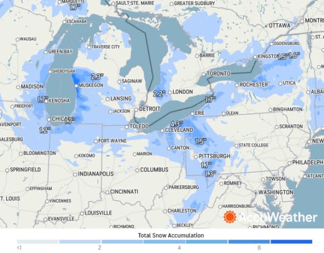
More than 6 inches of snow fell on parts of northeastern Minnesota and northern Wisconsin from Monday night to Tuesday morning. The Minneapolis-St. Paul International Airport picked up 2.7 inches of snow as a storm total as of 2 p.m. on Oct. 31, according to the National Weather Service (NWS).
Snowfall totals climbed into the double digits to the northwest of Grand Rapids, Michigan, inland from the shores of Lake Michigan. One location near Cloverville, Michigan, was buried under 11.5 inches of snow by midday on Halloween.
Chicagoans faced snow showers throughout the day and into the night on Halloween. Snow showers, enhanced by Lake Michigan, were intense enough to trigger thundersnow in downtown during the evening hours with visibility dropping to less than a mile. Roads were slick with ice as lingering moisture froze in the Chicago area on Wednesday morning.
🔈🌩 SOUND ON for some rumbling thundersnow in Chicago! pic.twitter.com/W876JxCT2h
— AccuWeather (@accuweather) November 1, 2023
As snow spread eastward, Cleveland picked up between 2 and 3 inches of snow with higher accumulations of up to 7.5 inches as of Wednesday morning over areas farther northeast across Ohio.
The heaviest snow accumulation reported in Pennsylvania was 10 inches near Hannasville, located in the northwestern part of the state. Snowfall was on the order of 3-5 inches to the south and east of Lake Erie. A coating to an inch-plus occurred through portions of central Pennsylvania.
AccuWeather National Reporter Bill Wadell said that the Pennsylvania Department of Transportation was out salting roadways early Wednesday morning. PennDOT has a stockpile of 700,000 tons of road salt ready to treat roads across the Keystone State, a spokesperson told Wadell.
Lorraine, a location downwind of Lake Ontario in upstate New York, had 7 inches of snow by early Wednesday morning.
 |
Snow amounts from noon Oct. 31, 2023, to noon Nov. 1, 2003. |
Just days earlier, Denver picked up its first accumulating snowfall of the season, with snow piling up on Halloween decorations. A total of 7.5 inches of snow buried the Mile High City over the weekend as a storm took shape over the south-central U.S., spreading snow and ice across portions of the Plains.
The U.S. and southern Canada had the most extensive snow coverage on Oct. 31 and Nov. 1 on record since the National Operational Hydrologic Remote Sensing Center began tracking data in 2012.
On Halloween, 17.5% of the U.S. and southern Canada had snow on the ground. The second-snowiest Oct. 31 occurred in 2019 when 16.9% of the U.S. and Canada was covered by snow. The percentage jumped up slightly to 17.9% on Nov. 1, also the highest recorded for the date, and above the Nov. 1, 2019, figure of 16.9%.
 |
A record 17.9% of the United States and southern Canada were covered by snow on the morning of Nov. 1, 2023. (National Operational Hydrologic Remote Sensing Center) |
"There have been 2,700 local storm reports of ice or snow over the last week," AccuWeather Meteorologist and Social Media Producer Jesse Ferrell said on Wednesday.
•Have the app? Unlock AccuWeather Alerts™ with Premium+
On top of that, a notable cold wave sunk its teeth into the U.S. Nearly 120 million Americans experienced temperatures at or below freezing on Wednesday morning.
The North Carolina Climate Office confirmed that Mt. Mitchell, the highest elevation east of the Mississippi River at 6,684 feet, recorded its earliest single-digit temperature on record when the low temperature plummeted to 8.4 F on Wednesday morning.
Want next-level safety, ad-free? Unlock advanced, hyperlocal severe weather alerts when you subscribe to Premium+ on the AccuWeather app. AccuWeather Alerts™are prompted by our expert meteorologists who monitor and analyze dangerous weather risks 24/7 to keep you and your family safer.
