Millions of Americans at risk of severe thunderstorms on July Fourth


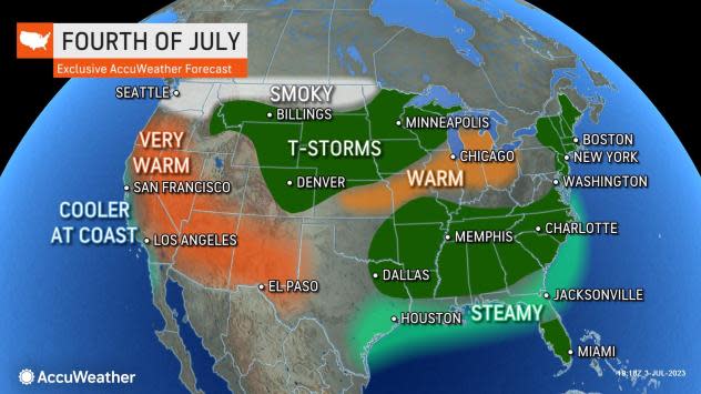
Independence Day could be a volatile one across the central, southern and eastern United States as the atmosphere looks primed to produce rounds of severe thunderstorms into Tuesday night, AccuWeather meteorologists warn.
This region has already been hard hit by rounds of intense storms this week. On Monday, dozens of damaging wind reports were received by the Storm Prediction Center, most of which were concentrated from Virginia to New York. Storms reached their peak around the Chesapeake Bay, where an 84 mph wind gust was recorded in Tilghman Island, Maryland. Several thousand utility customers remain without power in the Mid-Atlantic, mostly in Virginia.
Nevertheless, the greatest hazard from thunderstorms isn't wind, hail or even tornadoes. By far, the greatest risk for people spending time outdoors during the holiday and days later this week will be from lightning strikes. As a general rule, experts say if distant thunder can be heard, there is a risk of a lightning strike in the vicinity.
 |
U.S. lightning fatalities between 2012 and 2022. Information complied by John Jensenius. (National Lightning Safety Council) |
Forecasters urge that people move indoors at the first rumble of thunder for this reason. Picnic pavilions, tents and golf carts do not offer adequate protection from a lightning strike. Standing beneath a tree or on a porch can be dangerous as well.
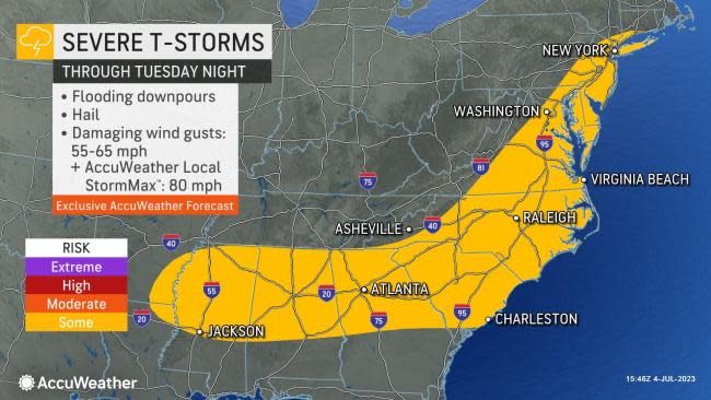
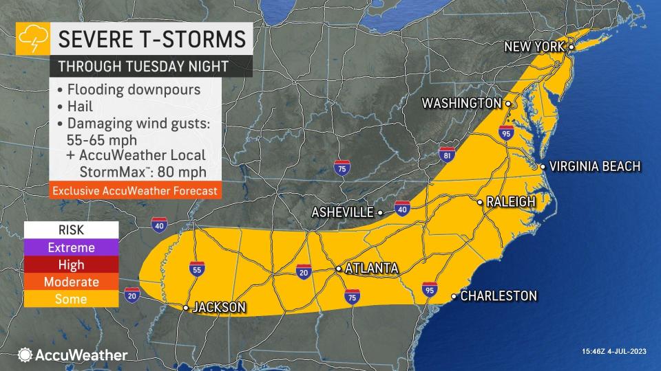
Storms will be active across a huge swath of the eastern and southern United States through Tuesday evening. This zone will include areas from near New York City to eastern Arkansas and northeastern Louisiana. Some of the thunderstorms may become severe with flooding downpours, strong wind gusts and hail. In New England and on through southeastern New York state and New Jersey, slow-moving, repeating downpours, including embedded thunderstorms, will raise the risk of flooding.
 |
The more robust storms will pack frequent wind gusts between 55 and 65 mph. In the strongest storms, an AccuWeather Local StormMax™ gust of 80 mph is possible -- winds of that magnitude are above the minimum threshold for a Category 1 hurricane (74 mph).
Storms are also expected to be rather isolated for some, especially in the Mid-Atlantic and Northeast. While this will allow some locations to be spared rain entirely, conditions will change rapidly over short distances as storms develop.
AccuWeather meteorologists believe that most of the thunderstorms from New York City to Philadelphia and Washington, D.C., will have pushed to the east by sunset. However, light winds and lingering moisture in the air around fireworks time could lead to hazy and foggy conditions that could potentially obstruct viewing conditions.
 |
"There will be a pool of dry air to the west that may slide in just in time to prevent fog Tuesday evening, but that is not a guarantee," AccuWeather Senior Meteorologist Dave Dombek said.
Clouds and drenching thunderstorms may persist through the nighttime hours in central and eastern New England and well into the evening in areas from southeastern Virginia to portions of the Interstate 20 and 85 corridors in the Southeast. Motorists may encounter flooded roads on their travels.
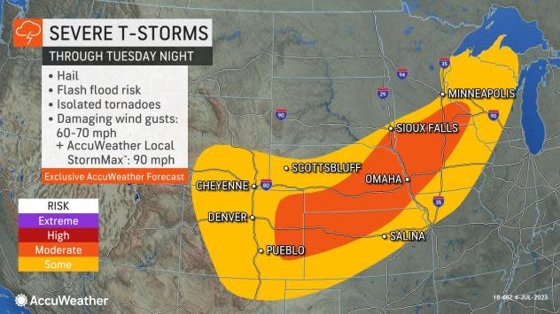
A large area of severe weather is likely over the wide open spaces of the Plains into Tuesday night.
"The July Fourth holiday and evening festivities may be marred by severe storms erupting from the Rockies in Colorado and part of southern Wyoming to much of Wisconsin and the Upper Peninsula of Michigan," AccuWeather Meteorologist Alex DaSilva said. Denver and Omaha, Nebraska, are among the major cities at risk for severe weather.
 |
"These storms are likely to produce damaging winds, hail and torrential downpours," DaSilva said. "Localized flash flooding is possible, as well as a few tornadoes, in the strongest storms."
While the intensity and coverage of thunderstorms will tend to diminish and shrink on Wednesday in the Eastern states, severe weather will remain a concern for portions of the central U.S.
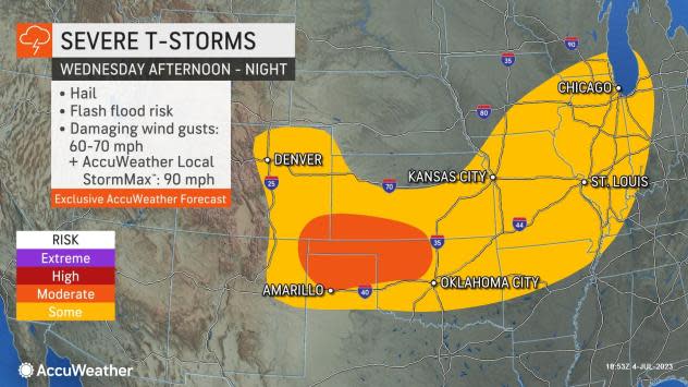
The risk of severe thunderstorms on Wednesday afternoon and evening will extend from the High Plains of northeastern Mexico and eastern Colorado to western Kentucky, Indiana and the western portion of the Lower Peninsula of Michigan. These storms will be capable of unleashing flooding downpours as well as frequent wind gusts between 60 and 70 mph.
 |
The strongest storms in this zone on Wednesday may produce hail and an AccuWeather Local StormMax™ wind gust of 90 mph. Some of the major cities that could be affected by powerful storms at midweek include Denver, Chicago and St. Louis and Kansas City, Missouri.
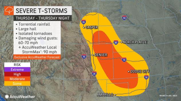
On Thursday, the risk of severe weather will continue in parts of the Plains, mainly from the western parts of Nebraska, Kansas and Oklahoma to the eastern parts of New Mexico, Colorado and Wyoming.
"There is the potential for a complex of severe thunderstorms to develop in northeastern Colorado late Thursday and then roll southeastward into Kansas during Thursday night," AccuWeather Senior Meteorologist Alyson Hoegg said.
 |
Meanwhile, thunderstorms will not be a problem for most locations west of the Rockies to the Pacific coast through the middle of the week. However, building heat and smoke from western Canada wildfires could make for dangerous conditions to be outdoors in part of the Northwest.
Want next-level safety, ad-free? Unlock advanced, hyperlocal severe weather alerts when you subscribe to Premium+ on the AccuWeather app. AccuWeather Alerts™ are prompted by our expert meteorologists who monitor and analyze dangerous weather risks 24/7 to keep you and your family safer.
