Mississippi River Basin Model in Jackson to celebrate 80th anniversary. Details here
- Oops!Something went wrong.Please try again later.
Mississippi River Basin Model (1969) from Ron Rodenmeyer on Vimeo.
The 80th Anniversary Celebration of the Mississippi River Basin Model will give visitors a rare opportunity to see what has been described as the largest hydraulic model in the world from 2 until 6 p.m. Saturday, Oct. 14, at Buddy Butts Park, 6180 McRaven Road in Jackson.
The event will feature STEM (science, technology, engineering and mathematics) activities and demonstrations from 2 p.m. until 4 p.m. with guided tours of the model beginning at 3:45 p.m. and 5 p.m.
The event also will feature a movie screening of “Dream Big,” which celebrates the human ingenuity behind engineering marvels ranging from the Great Wall of China to the world’s largest buildings.
Food and beverage trucks will be on hand all afternoon offering a variety of menu items for sale.
The 210-acre river model, which is now owned by the City of Jackson, was developed by the U.S. Army Corps of Engineers as a way to study and control flooding along the Mississippi River and the rivers that feed into it following the Great Flood of 1937 in which the Ohio River tributary flooded a decade after the Great Mississippi River Flood of 1927.
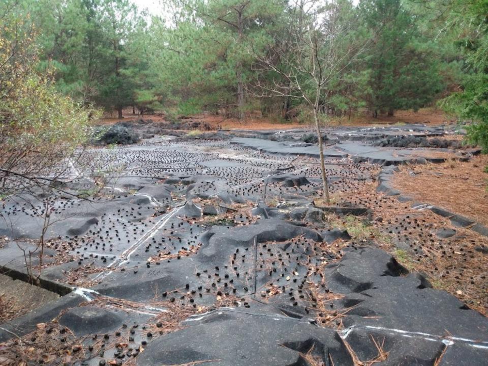
Essentially designed as a giant, three-dimensional topographic map, the site features the hills, rivers, lakes and valleys of roughly 41% of the entire continental United States, all molded into concrete.
Over the years, the facility was credited for saving lives and preventing millions of dollars in damages. But with the advent of computer modeling, operations at the facility were eventually abandoned.
Destructive forces of nature, neglect and vandalism began to take hold by the early 2000s, and the model would likely have been all but forgotten today were it not for the efforts of a small, all-volunteer group which has taken on the Herculean task of trying to restore it.
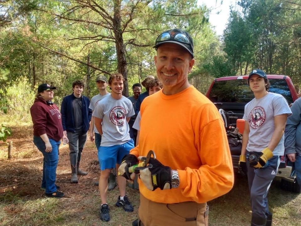
The group, called Friends of the Mississippi River Basin Model, which is sponsoring Saturday’s event, is headed by President Aaron Morris.
Morris, who last weekend was leading a clean-up crew making preparations for this Saturday, said he hopes the anniversary celebration will increase public awareness and support for what he believes could again become a top educational and tourist attraction.
“We have recently secured a designation of the site as a National Historic Engineering Landmark,” he said.
Alysia Hanks, a Hinds Community College student who was among the volunteers pitching in for the clean-up, described the site as “very rich in history.” She said, “It’s kind of sad to see how it has regressed but it would be amazing to see it restored.”
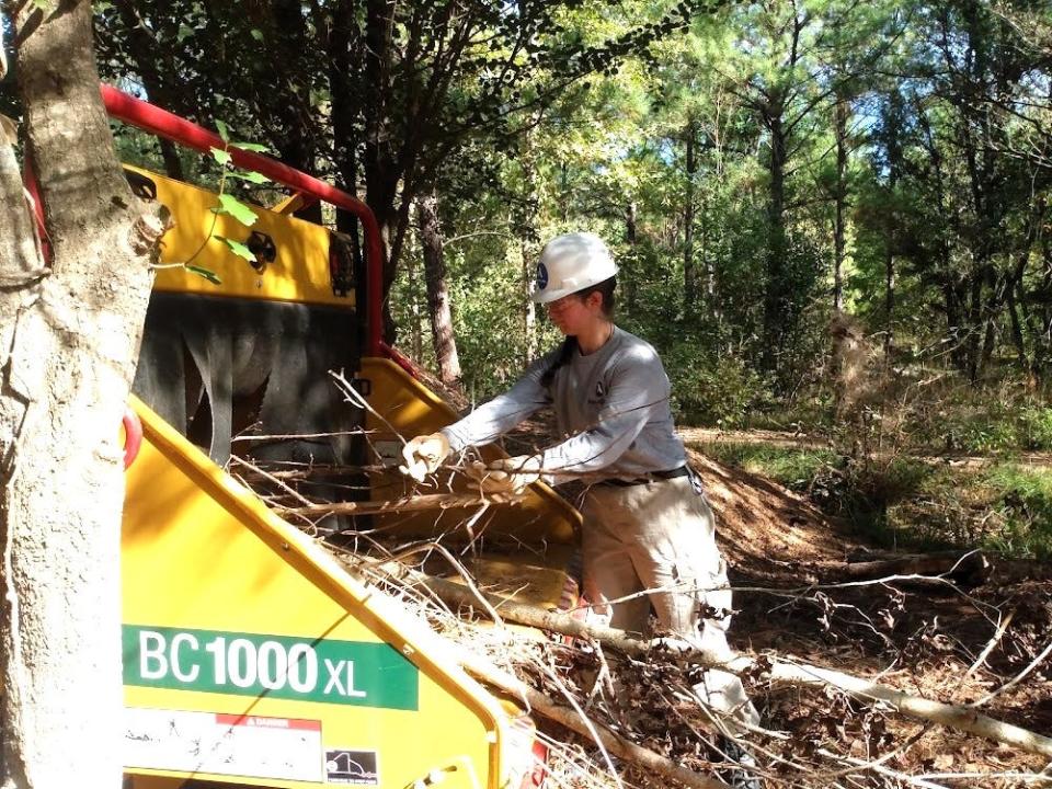
Brandon Copeland, another Hinds student who spoke over the roar of AmeriCorps volunteers feeding thousands of limbs into a wood chipper donated by Vermeer MidSouth Inc., agreed.
“It’s a shame to see it has gotten to this point,” Copeland said. “It would be a really neat thing to be able to restore.”
Construction first began in 1943, initially using labor from World War II prisoners of war being held at a nearby camp in Clinton.
Built to precise scale, a mile on the Mississippi River (and other rivers including the Missouri, Ohio and Arkansas that feed into it) equals 2.64 feet on the model. A cubic foot per second of water pumped through the model would represent 1.5 million cubic feet of water passing through an actual river per second.
Operations made it possible to determine how the height of levees at given points could protect lower lands and how reservoirs could similarly protect communities downstream.
The value of such information was proven as early as 1952 when a major flood impacted the Missouri River near Omaha. By running the model around the clock for 16 days, engineers were able to simulate conditions faster than the actual flood waters would rise, allowing officials in the affected areas to make emergency preparations in advance.
As a result it was estimated that data from the model helped to prevent over $65 million in damages.
At the height of operations in the 1950s and '60s the model maintained a staff of about 28 people including seven full-time engineers. But by the early 1970s the Corps of Engineers believed much of the data being obtained was duplicative and not worth the expense.
The story of how the City of Jackson obtained title to the facility is somewhat convoluted. When the Corps first announced plans to phase out the model in 1974, the city applied to take ownership through a federal program administered through the U.S. Department of the Interior.
Then-Jackson Mayor Russell C. Davis pledged to keep the facility open as a tourist attraction, which at the time was attracting some 20,000 visitors annually.
But the Corps reversed course at the 11th hour when a major flood hit the Mississippi River in early 1975 and they discovered then-emerging computer models of the time left some questions unanswered.
They decided they wanted to keep the facility open after all.
By one newspaper account, the city then agreed to lease the land back to the Corps of Engineers for 20 years at a nominal price of $1 per year. Though details of that agreement remain sketchy, it is known that the Corps continued to operate the facility full time for another 10 years and later maintained a skeleton staff at the site into the early 1990s.
“The final test was conducted in 1993,” Morris said. Soon thereafter the city finally took control.
For about a decade Jackson officials took some steps to cut the grass and maintain the river model grounds at what was by then known as Buddy Butts Park. But the primary focus in those days was maintaining soccer fields, hiking trails and other recreational facilities at the park.
It eventually became evident that the city had neither the money nor the expertise to properly maintain the Mississippi River Basin Model. By 2004 the city stopped maintenance altogether. Hundreds of trees started popping up throughout the fields, and the facility was simply fenced off, presumably to be forgotten.
When the Clarion Ledger last visited the model in June, 2015, reporter C. Todd Sherman wrote: “Beyond a rusty chain link fence of a Jackson park lies a piece of national history in ruin.”
So what has changed now eight years later?
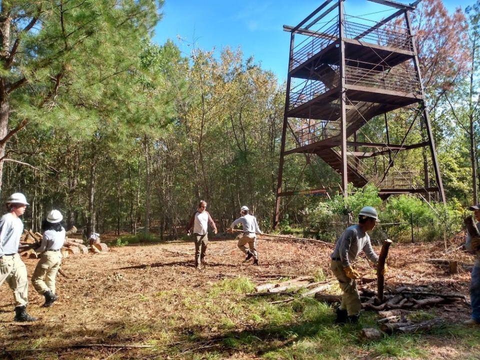
Quite a lot, says Morris. Since the all-volunteer Friends group was formed in 2016, “we have cleared nearly 7 acres of trees and made numerous walkways and paths accessible again.”
Additionally, over 18,000 cubic feet of “hydraulic mesh,” a type of wire once used to replicate forests and vegetation during model experiments, has been removed to expose the concrete model for better visibility.
Morris believes that represents “a great stride in providing access.” He particularly credits troops from the local area Andrew Jackson Council of the Boy Scouts, honor students from the Raymond and Rankin County branches of Hinds Community College, and AmeriCorps volunteers for their hard work in making the progress during monthly clean-up days.
Long term plans, if funds become available, are to make a portion of the model once again functional and to build a new Education and Science Center to allow future generations of students to learn about engineering and the sciences.
Additional volunteers are always encouraged to get involved. You may visit friendsofmrbm.org or email the group at friendsofmrbm@gmail.com for more information.
Admission to Saturday’s activities are free. To reach the Mississippi River Basin Model take Springridge Road south from Interstate 20 in Clinton then turn left onto McRaven Road headed east toward Jackson. Buddy Butts Park will be your first entrance to the left.
Author’s note: I first became aware of the Mississippi River Basin Model as a small child in 1969 when my mother took me to visit, allowing me to bring a Super 8 movie camera. The resulting hand-held footage, though amateurish, can be seen by visiting vimeo.com/26039372 for anyone wanting a rare glimpse of how the model appeared while still in full-scale operation.)
This article originally appeared on Mississippi Clarion Ledger: Mississippi River Basin Model in Jackson MS to celebrate 80th anniversary

