New models show tsunami's effects on Kitsap after Seattle Fault quake
If (or when) a 7.5-magnitude earthquake erupts on the Seattle Fault, beneath Kitsap County and a large part of Bainbridge Island, the shaking will last around 30 seconds.
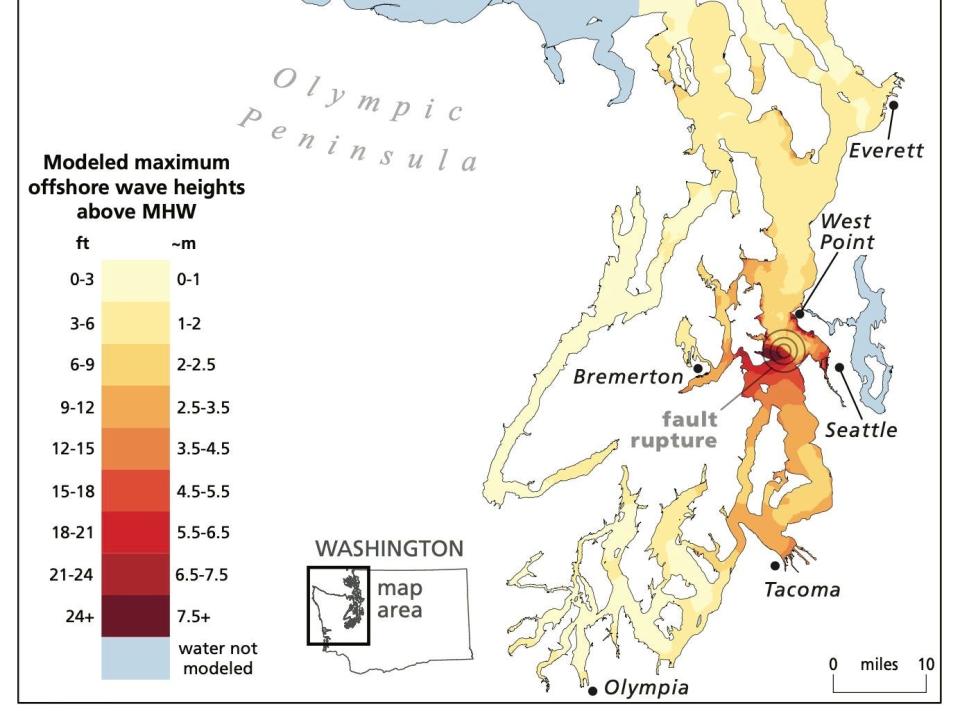
For people on the shoreline at that time, or waiting to get on the ferry or riding through Rich Passage, models suggest that strong waves will arrive in less than three minutes. Waves could exceed 20 feet on the southern shore of Bainbridge Island. The shoreline across Kitsap County will change — someone standing on Restoration Point will, in the days after the earthquake and tsunami, be 23 feet higher than the original shoreline. Someone standing at the Bainbridge Ferry terminal will be around 6 feet lower than before, and continuing waves could flood the area multiple times.
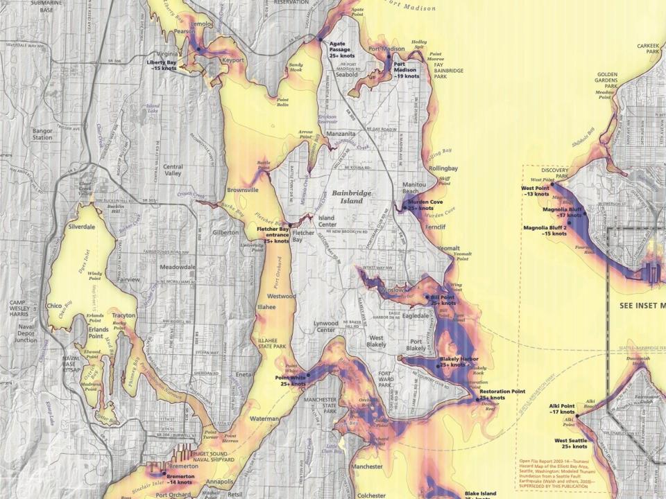
Currents off the shore of the island, around somewhere like Eagle Harbor, could exceed 25 knots, threatening boats and other small vessels on the water. And for three to 10 hours after the earthquake, the tsunami will continue to wreak havoc on the region.
All of these projections are part of a recent report released by the Washington State Department of Natural Resources. The agency modeled wave heights, water current speeds and shoreline changes that could occur after an earthquake and resulting tsunami on the Seattle Fault.
The Seattle Fault is one of many beneath the Puget Sound region. A group of faults — known as the Seattle fault zone — runs horizontally between Lake Sammamish and Hood Canal, underneath Seattle, Elliott Bay and large portions of southern Kitsap County. The last earthquake on the fault happened around 1,100 years ago, according to the DNR report, with an estimated magnitude between 7.0 and 7.5.
More: New research reveals Cascadia tsunami would flood Navy piers, highways
Alex Dolcimascolo, a tsunami geoscientist at the Washington Geological Survey and lead author of the report, says there is a 5-7% chance the next earthquake occurs in the next 50 years. And the actual earthquake would likely be less intense than what the models show, according to Dolcimascolo. But the report, which models a rupture on just one of the Seattle Fault lines, still poses a threat to Kitsap County and the greater Puget Sound region.
Wave arrival
The first tsunami waves after the modeled earthquake will arrive on Bainbridge Island and the Bremerton shoreline within three minutes of the Seattle Fault earthquake. At the Kingston Ferry Terminal and in Liberty Bay, residents will have 15 minutes before the first wave rises up. Waves will continue to arrive on Kitsap County shorelines for nearly the next hour.
Wave height
The models show waves 24 feet and higher hitting Restoration Point on Bainbridge Island. In Bremerton, waves around 9 feet will crash near the ferry terminal. In Kingston, waves closer to 5 feet will land on the shore. And according to Dolcimascolo, the waves won’t look like anything you can surf.
“It will look like a wall of water coming at you that’s rising very fast,” he said.
An altered shoreline
One of the biggest changes a Seattle Fault earthquake will bring to Kitsap County is an altered shoreline.
North of the fault, the shoreline is predicted to drop by up to 6 feet; south of fault, the land will rise by more than 23 feet. The Bremerton Ferry terminal will experience between 6 and 7 feet of uplift, according to Dolcimascolo. And that provides protection against secondary waves, which wouldn’t be large enough to reach the land after the uplift.
But north of Eagle Harbor, the land drop of 6 feet could present an extra challenge: increased flooding. Lower shorelines mean less protection against recurring waves.
“This is an event that could last many hours with many different waves coming in and out,” Dolcimascolo said.
Current speeds
Current speeds near Blakely Harbor could exceed 25 knots. Any current speed above 9 knots creates the possibility for “extreme damage,” according to the report. Shallow water moves faster than deeper water, Dolcimascolo says, so any boats in the water and harbors could be at risk. At the Kingston Ferry Terminal, 9-knot currents could also complicate sailings and loading passengers and cars onto boats. Increased currents could also pose threats to Bremerton and Bainbridge Island sailings.
Kitsap County response
Lis Klute, director of Kitsap’s Department of Emergency Management, says the most important thing people can do right now is to educate themselves. “Get into the report, read the report. Look at the science. The more you know about the hazard, the less you have to fear it, because it means that you're informed and you can do what you're able to do to be prepared,” she said.
And that preparation can start immediately. Klute says water is the most important thing to stock — one gallon per person per day. Kitsap’s Department of Emergency Management also recommends creating a kit with a change of clothes, medicine and a paper bag with a pair shoes in case an earthquake leaves glass shards on the floor. The department recommends building a kit for two weeks' worth of supplies, but preparation up to three or four weeks is even better, says Dave Rasmussen, KCDEM public information officer.
Part of what the new report might change for emergency preparedness in Kitsap is the planned micro-islands, or areas that can serve as gathering spots for supplies distribution, across the county. And, unlike recent Cascadia Fault modeling, the report models that Bainbridge Island will be heavily impacted by a Seattle Fault quake.
“The two areas that are impacted the most are Bainbridge Island and downtown Seattle,” said Anne LeSage, Bainbridge Island’s emergency management coordinator, “so it really is changing the way we’re thinking about tsunamis on Bainbridge.”
Part of that change involves identifying neighborhoods that will be heavily impacted by a Seattle Fault quake. One of those is the area around Fay Bainbridge Park, which will be 11 feet underwater after the quake strikes and lowers the shoreline, according to the report. Areas across Bainbridge participate in a Map My Neighborhood program, which identifies contact information and a group plan for the time immediately following a disaster. Thirty-five percent of households on Bainbridge Island have participated in the mapping, according to LeSage. The remaining neighborhoods may require personal outreach or flyers detailing their risk of danger in an earthquake.
LeSage echoed the need to prepare enough food, water and other emergency supplies for up to three or four weeks. And she, along with Klute, encourages residents to reach out to their local emergency management department with questions and concerns.
“Because even in the uncertainty, there are still things you can do today to prepare your household and to prepare your neighborhood and to make sure that we're ready for whatever it is that happens,” LeSage said.
More information can be found on the DNR tsunami page, Bainbridge Island’s Local Hazards site and KCDEM’s Get Prepared website.
The full DNR report can be found here.
This article originally appeared on Kitsap Sun: How Kitsap will be effected by Seattle Fault quake's tsunami

