Monsoons produce 'the entire summer's rain in a single day' in Utah; more to come
Wednesday's rainfall totals in Utah were good enough to make up for a summer that has been, to this point, extremely dry.
KSL meteorologist Kevin Eubank said that the statewide storm, spread out between southern and northern Utah, brought "the entire summer's rain in a single day."
Here's a look at the areas that accumulated the highest totals:
Magna: 2.74 inches
West Valley City: 2.67 inches
Dugway: 1.66 inches
Kaysville: 1.47 inches
Vineyard: 1.25 inches
Eagle Mountain: 1.13 inches
Randolph: 1.04 inches
Genola: 1.01 inches
Fruit Heights: 0.99 inches
Nephi: 0.96 inches
Hurricane: 0.96 inches
East Layton: 0.83 inches
Herriman: 0.75 inches
St. George: 0.42 inches
Eubank added that while the storm subsided over much of the state Wednesday evening, Utah isn't in the clear just yet.
"There's precipitation out to the West. It's moving now from west to east and will eventually come back through northern Utah overnight tonight and into the morning tomorrow, bringing moderate to heavy rain between 1 and 4 a.m.," Eubank said.
With the monsoonal moisture back in Utah, so are higher risks of flash flooding.
The National Weather Service issued a new flood watch for the Wasatch Front and northern Utah on Wednesday afternoon, piling onto a previous flood watch issued for most of southwest and central Utah earlier in the day.
The advisory means that flash flood risks existed from Logan to St. George.
"Excessive rainfall may result in flooding of small streams, creeks and flood-prone areas, as well as localized urban flooding," the alert states. "Debris flows and mudslides from recent burn scars are also possible."
Kaysville flooding 😱😱😱
📸: Nathan Hole #utwx #ksltv pic.twitter.com/yKG3RSij1p— KSL 5 TV (@KSL5TV) August 2, 2023
The weather service's flood watch for southwest and central Utah expired at 10 p.m. Wednesday, while the new flood watch for the Wasatch Front and northern Utah expires Thursday afternoon.
The advisories come as low-pressure systems continue to pump moisture in from Arizona on Wednesday. KSL meteorologist Matt Johnson said a low-pressure system were moving northeast in Utah, producing more scattered showers and thunderstorms, especially Wednesday afternoon and evening.
The system, Johnson said, has "better dynamics," meaning that there's a higher likelihood of high precipitation totals within a storm. While there's no guarantee any spot in Utah will receive rain, the areas that do receive downpours may get a heavy dose all at once, which is why there's an elevated risk for flash flooding.
"They don't really have a direction," he explained. "They bubble up in one spot and die there, then pop up in another."
There is an increased risk of flash flooding for southern Utah National Parks and recreation areas. Make sure to check in with local visitor centers or ranger stations before heading out and have a plan if threatening weather approaches. More at: https://t.co/7kgSJIR7mF #utwx pic.twitter.com/OG6Uwxt0Mi
— NWS Salt Lake City (@NWSSaltLakeCity) August 2, 2023
Some of the storms have already materialized. The National Weather Service issued flash flood warnings for parts of south-central Garfield County and northeast Kane County, as well as the Jacob City burn scar in Tooele County on Wednesday.
The agency also issued a severe thunderstorm warning for areas across the Wasatch Front on Wednesday for a storm that developed in the afternoon.
Flooding near my house in Kaysville today. These people are crazy. Just find another way around and be safe. @KUTV2News @kslweather @KSL5TV pic.twitter.com/ao3CguZK0v
— Family On 3 (@ZacarySpilker) August 3, 2023
The National Weather Service wrote that flash flooding was "expected" Wednesday at Bryce Canyon, Capitol Reef and Zion national parks, as well as the Glen Canyon National Recreation Area, Grand Staircase-Escalante National Monument and the San Rafael Swell. Flash flooding was "probable" at Arches and Canyonland national parks, Natural Bridges National Monument and Grand Gulch.
Similar storms that developed Tuesday led to flash flooding and mudslides at Indian Canyon near Duchesne and at Alta in Little Cottonwood Canyon, according to the National Weather Service. Brian Head in southern Utah received 1.08 inches of rain on Tuesday, while Lone Peak received 0.97 inches and Morgan ended up with 0.74 inches.
The storms arrived after several Utah areas ended up with above-normal temperatures and below-normal precipitation throughout July.
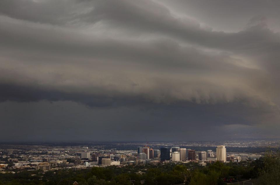
This time lapse shows the shelf cloud, or leading edge of the storm, passing over the SL Valley. pic.twitter.com/003iqA4qvv
— KSL Weather (@kslweather) August 2, 2023
In addition to flash flood warnings, the storm caused 12 flight delays and one cancellation at the Salt Lake City International Airport, according to Nancy Volmer, the airport's director of communications.
Meanwhile, the system passing through Wednesday is expected to clear up early Thursday morning before another wave of scattered showers later in the day. However, these storms likely won't produce as much precipitation, Johnson said.
The current forecast calls for drier conditions to develop by the weekend. High temperatures are forecast to top out in the upper 80s and lower 90s across the Wasatch Front, and the lower 100s in St. George.
Full seven-day forecasts for areas across Utah can be found online, at the KSL Weather Center.
