Monster Pacific storm to 'firehose' California with rain, flooding and wind

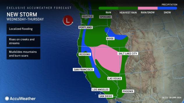


A potent storm with plenty of moisture will throw heavy rain and gusty winds at the West Coast of the United States this week, with most of the focus on California from Wednesday to Thursday. As AccuWeather meteorologists have warned since mid-January, the upcoming storm will trigger an atmospheric river that can bring rain heavy enough to trigger flooding, mudslides and major travel disruptions.
The storm will approach midweek after a potent winter storm pushed inland over British Columbia, producing showery rain and mountain snow in the Northwest on Tuesday.
This new storm will deliver a narrow zone of intense rain, or an atmospheric river, from well out over the Pacific and toward coastal areas of California. The firehose effect of rain will shift southward from Northern California on Wednesday to Southern California on Thursday.
 |
The storm will create significant disruptions for travel across a good portion of the state from Wednesday through Thursday as the heavy rain spreads southward, AccuWeather Senior Meteorologist Heather Zehr said.
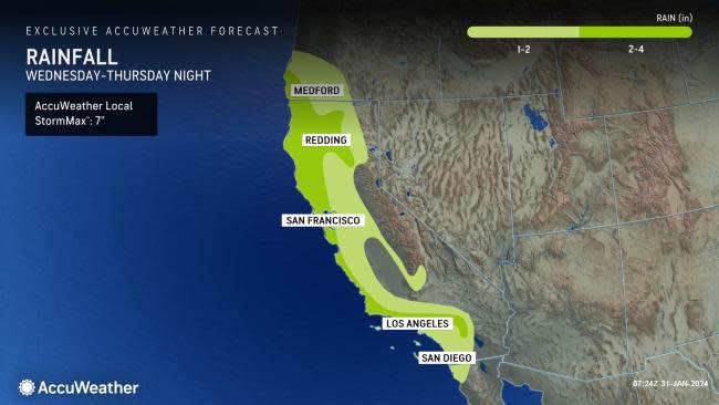
"A large area where 2-4 inches of rain will fall includes much of Northern California, with locally higher amounts, generally between 4 and 6 inches, being unleashed on the west- and southwest-facing Coast Ranges," Zehr said. "The anticipated 2-4 inches of rain includes the San Francisco area, with 1-2 inches likely farther inland around Sacramento, California."
"Rain from the storm will spread over the San Francisco Bay area (and Sacramento) on Wednesday with the heaviest likely during Wednesday afternoon and night," AccuWeather Storm Warning Meteorologist Joseph Bauer added.
The drenching rain will reach Los Angeles and San Diego on Thursday when the heaviest downpours are likely.
 |
"Several inches of rain is likely to fall all along the Central California coast, and persistent southwesterly breezes associated with the atmospheric river to bring widespread 1-2 inch amounts to Southern California," Zehr said.
Some areas, especially along the west- and southwest-facing mountainsides in Santa Barbara and Ventura counties, will get locally higher totals, perhaps exceeding 4 inches. The AccuWeather Local StormMax™ is 7 inches.
Quick movement of the storm will limit rainfall totals. However, much of the forecast rain will fall in 24 hours, and with the amount anticipated, runoff will be substantial and quick.
Regional flash flooding problems are likely, with incidents of debris flows, rockslides and washouts as well, Bauer said. Small streams will rise rapidly, and some of the rivers in the northern and central parts of the state may flood.
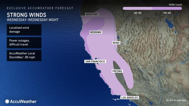
"This storm will also pack some strong gusts, with non-windy areas of the state getting in on 20- to 40-mph blusters. Areas on the coast could gust over 50 mph, which, given the saturated ground, could lead to localized power outages," Bauer said. The wet soil may allow trees to topple over more easily than if the same wind in dry soil conditions.
The storm will churn up large waves and send them toward the California coast from Wednesday to Saturday. While conditions are not likely to become as severe as early January, there is the potential for coastal erosion, overwash and flooding.
 |
The storm will pull in colder air as it progresses southward, leading to deteriorating wintry travel conditions over the mountains.
Much of the Sierra Nevada can get a significant wet snowfall with freezing levels starting above pass level on Wednesday, falling to pass level Thursday then dropping below pass level by Friday, Bauer said.
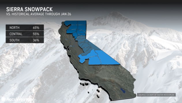
The current Sierra Nevada snowpack is running well below average pace for late January. In the northern Sierra, the season-to-date tally is 65%, while in the southern Sierra, the amount is 36%. The storm from Wednesday to Friday should provide a boost.
 |
"Snow can fall to as low as 4,000 feet by Friday over the northern and central Sierra Nevada with accumulations of 1-2 feet likely in the highest elevations, including along Interstate 80 at Donner Pass, California," Zerh added.
Even the Southern California mountains will get snow at the end of the week.
"There could be a small, slushy accumulation through Tejon and Cajon passes from late Friday into Friday night," Zehr said. Motorists venturing over the high ground on I-5 and I-15 should be prepared for slippery conditions and delays.
 |
Skiers and snowboarders will welcome the snow, and it could be a good weekend to head to the resorts.
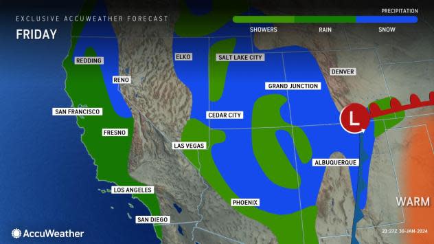
However, as the storm pushes across the Intermountain West late this week and into this weekend, it could lead to travel problems. For example, around Denver, a mixture of rain and snow is in the offing from Friday night to Saturday with accumulating snow in the foothills and over the Colorado Rockies.
There is still plenty of winter to go, with opportunities for more snow in the Sierra Nevada immediately behind the storm to end this week.
Another storm may eye much of California with low-elevation rain and mountain snow from Sunday to Monday. Even though that storm may not be as intense as the storm from Wednesday to Friday, it can bring enough beneficial and problematic rain and snow to the state.
 |
Rainfall from Oct. 1 through Jan. 28 along the California coast ranges from 75-110% of the historical average. Across California's interior valley, rainfall ranges from 50-100% of average for the same period. The storm from Wednesday to Friday should bring the seasonal rain close to or above the average.
Want next-level safety, ad-free? Unlock advanced, hyperlocal severe weather alerts when you subscribe to Premium+ on the AccuWeather app. AccuWeather Alerts™ are prompted by our expert meteorologists who monitor and analyze dangerous weather risks 24/7 to keep you and your family safer.
