More than 400 toxic sites in California are at risk of flooding from sea level rise
When Lucas Zucker talks about sea level rise in California, his first thoughts aren’t about waves crashing onto fancy homes in Orange County, nor the state’s most iconic beaches shrinking year after year.
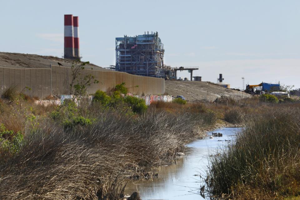
What worries him most are the three power plants looming over the Oxnard coast, and the toxic waste site that has languished there for decades. There are also two naval bases, unknown military dumps and a smog-spewing port. Just one flood could unleash a flow of industrial chemicals and overwhelm his working-class, mostly Latino community.
"The coast of California is marked by massive inequality. People don't realize that because they go to Malibu, they go to Santa Barbara. Those are the beaches that people see and are familiar with," said Zucker, a longtime advocate for environmental justice. "They don’t think of places like Wilmington, West Long Beach, Barrio Logan, West Oakland, Richmond, Bayview-Hunters Point. You can name all these communities, and it's the same story."
These predominately Black and brown communities, in fact, are five times more likely than the general population to live within half a mile of a toxic site that could flood by 2050, according to a new statewide mapping project led by environmental health professors at UC Berkeley and UCLA. All told, the ocean could inundate more than 400 hazardous facilities by the end of the century — exposing nearby residents to dangerous chemicals and polluted water.
This three-year project, dubbed Toxic Tides, is the first systematic look at the environmental justice ramifications of sea level rise and hazardous sites along the entire coast of California. In collaboration with advocates like Zucker, researchers created a series of searchable maps that piece together where in California this flooding could occur, which industrial facilities face particularly risk, and how these threats disproportionately affect lower-income communities of color.

This new analysis, released Tuesday during a virtual workshop, comes at a time when more officials and state legislators are starting to confront the social and economic realities of sea level rise and climate change. Across California, high surf is already flooding homes. Major roads, utility lines and other critical infrastructure are dangling ever closer to the sea.
In just the next decade, the ocean could rise more than half a foot — with heavy storms and cycles of El Niño projected to make things even worse.
A growing body of research is now investigating how rising water will flood communities built on or near contaminated land. Efforts to study this issue in the San Francisco Bay Area have become increasingly coordinated, and state toxic substances control officials have started their own mapping project. At Cal State Long Beach and Cal State Northridge, a team of researchers recently launched a project to examine which communities in the state could be most harmed by potential flooding of industrial chemicals currently stored underground.
"This is where the conversation absolutely has to go,” said Patrick Barnard, whose research team at the U.S. Geological Survey has done extensive flood modeling used by officials across the state. “We've made a lot of progress in terms of sea level rise projections. The next important step is: How do we translate that into vulnerability and impacts?"
With the new Toxic Tides project, two environmental health scientists — Rachel Morello-Frosch, at UC Berkeley, and Lara Cushing, at UCLA — teamed up with Zucker and a number of community groups to design an online tool that could help fill some data gaps in this less-talked-about realm of sea level rise.
They sorted through reams of information from federal databases that keep track of landfills, toxic cleanup sites, oil wells, refineries, sewage treatment plants and other industrial facilities. Working with the nonprofit science and news organization Climate Central, they integrated various sea level rise scenarios. Finally, they pieced together which communities could be most at risk.
Throughout this process, they turned to those living in threatened communities for help identifying data gaps. Community organizers also provided insight into which data points to use — beyond race and income — as a measure of social vulnerability.
If most of the residents living near a toxic site are not fluent in English, for example, the barriers to understanding the flood risks — and how to advocate for solutions — are far greater. Voter turnout, unemployment, the percentage of people who actually own their home (or even a car) are also factors indicating how much a community lacks political power, insurance protection and even the ability to evacuate in an emergency.
"We know from past flood events that the wealthy communities are not the ones that suffer the greatest impacts," Cushing said, pointing to recent disasters in New Orleans and Houston. "The vulnerabilities of environmental justice communities to sea level rise have not been front and center in the conversation in a way that it should be."

Zucker, policy director for the economic and environmental justice group CAUSE, said he never had the data to make his case. During presentations to various policymakers, he has always spoken anecdotally about the struggles in Oxnard — and then did his best to link to similar stories he’s seen in other communities across California.
Now, he said, he can pull up this map and zoom in on all the hot spots. In the community of Wilmington near the Port of Los Angeles, for example, where many residents routinely report dizziness, nosebleeds and headaches, more than 10 industrial facilities, landfills and incinerators — and two dozen oil and gas wells — are projected to routinely flood in the coming decades.
And in the South Oxnard and Port Hueneme area alone, there are nine hazardous sites at risk of flooding. The Halaco Superfund site — contaminated by decades of metal recycling and awaiting cleanup since 2004 — is projected to flood at least seven times per year by the end of the century.
"The clock is ticking for communities that know these cleanup efforts have taken so long already — and are likely going to continue to take incredibly long amounts of time," said Zucker, who is now working with the Asian Pacific Environmental Network, Physicians for Social Responsibility-Los Angeles and other project partners to help communities translate these maps into action.

Kristina Hill, a UC Berkeley researcher who has spent years studying this issue in specific Bay Area communities, said the flooding could hit neighborhoods even sooner than projected.
"This is the tip of the iceberg," said Hill, who noted that factoring in storm surges, high tides — and especially groundwater that gets pushed up as the sea moves inland — will paint an even clearer picture of just how soon the chemicals buried in a toxic site could start to move into the pipes or cracks of homes.
"No one is really tracking the effects of tides, for example, during the wet season on the underground movement of these chemicals," said Hill, who teaches environmental planning. "Before the waves even get to these sites, as sea level rises, it's already a toxic soup spreading underground."
This issue has been a top priority for Mark Gold, the governor’s deputy secretary for coastal and ocean policy. He’s encouraged by the record amounts of money the state dedicated this year to climate change adaptation, he said, including major sea level rise legislation that specifically earmarks additional funding for coastal communities that are disproportionately burdened by industrialization.
The research now focusing on contaminated sites, he said, “is extremely important because it helps identify areas that need to be prioritized for cleanup.”
As more funding and political attention turn to sea level rise, many caution against the tendency to reinforce existing environmental injustices. It is not a coincidence that lower-income communities of color are the ones living with freeways, refineries and other hazardous infrastructure that no one wants in their neighborhood.
"Our culture and our society are measured in great part in where we invest our dollars," said Effie Turnbull Sanders, the California Coastal Commission’s environmental justice commissioner. "The more data we have, the more opportunity we have to disrupt the status quo and paint a picture that truly exposes the discriminatory land-use policies of the past — and those that continue into the future."
At the Oakland Shoreline Leadership Academy, a new program that guides residents through the technical world of coastal planning, Phoenix Armenta has spent years manually piecing together this picture.
Armenta often starts with a presentation that maps the neighborhoods in Oakland that had been redlined in the 1930s. On the next slide, Armenta overlays a map showing all the toxic sites in the city. Then a map of all the neighborhoods that could be flooded by sea level rise.
"This is the crux of the problem," Armenta said, noting the stark overlaps. "We have allowed certain populations to bear the brunt of the pollution of our industry, and because they've been vulnerable populations, we haven't done anything about it."
This story originally appeared in Los Angeles Times.

