More heavy rains, flash flooding possible in southwest Illinois. Here’s the forecast
The metro-east could experience more flash flooding Monday evening into Tuesday morning, according to the National Weather Service of St. Louis.
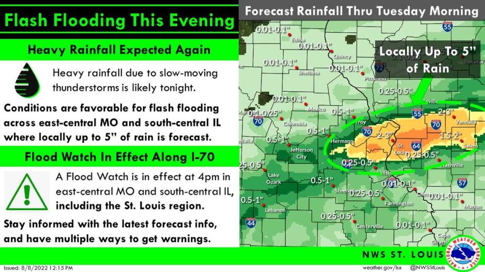
The area will be under a flash flood watch beginning at 4 p.m. Monday that extends into 4 a.m. Tuesday. Patrick Walsh, a meteorologist with the agency, said the metro-east could see 2-3 inches of rain with the potential of up to 5 inches in certain spots.
The watch area currently includes St. Clair, Madison, Monroe and Clinton counties.
“There’s a slow moving cold front moving down from Iowa into northwest Missouri at this time,” Walsh said Monday afternoon. “Along this front, we’re going to have some showers and thunderstorms develop. As it moves into the metro area, we’re going to see another round of slow moving storms capable of producing heavy rains.”
Walsh could not pinpoint which metro-east cities are most at-risk for heavy rainfall amounts, while noting the rain likely will first move into the area around 6-8 p.m.
“We’ll likely have some showers ahead of the main event,” he said. “When the heaviest rain gets here will just depend on how exactly these storms develop, where they set up and how slow they’re moving.”
Walsh gauged the heaviest downpours likely will occur around 3 or 4 a.m. and that the rain should be out of the area by mid-to-late Tuesday morning.
“And then we’ll have a cool down. The highs Tuesday will be in the low 80s,” he said.
After multiple consecutive days of temperatures above 90 degrees, the metro-east remains under a heat advisory until 7 p.m. Monday. The heat index is north of 100 degrees Monday as well.
“Hot temperatures and high humidity may cause heat illnesses,” the NWS warns on its website.
As far as flooding precautions, Walsh urged people to steer clear of standing water while driving.
“Probably the biggest thing we’ve seen past few rain events is people driving into the water. Turn around. There’s probably a different way around it,” he said.
The National Weather Service recommends keeping plugged into the forecast as it develops at www.weather.gov. Their Facebook page is www.facebook.com/NWSStLouis.