Dangerous storms to unleash high winds, tornadoes across north-central US


AccuWeather forecasters say that more severe weather is on the way for the north-central United States this week after severe thunderstorms rolled through portions of the region Monday.
"An unusually early and strong surge in heat and humidity over the Central states will be a major factor in severe weather for the balance of this week and especially from Wednesday evening through Thursday," AccuWeather Senior Meteorologist Alex Sosnowski said, adding, "in many cases, the pattern and behavior of severe weather over the north-central region this week will be more typical of July, rather than early May."
Monday's threat of severe storms lived up to expectations with a concentration of large hail and damaging winds reported in Minnesota and Wisconsin. Hail the size of baseballs fell on Blomkest, Minnesota. More than five dozen incidents of large hail and four tornadoes were reported, according to the National Weather Service's Storm Prediction Center.
While the heaviest rain avoided areas around the Red River of the North, some downpours did occur and could lead to a secondary rise along a portion of the river in the days ahead. Major flooding was ongoing from Oslo, Minnesota, north into southern Manitoba, Canada, as of Tuesday morning.
Heavy rain fell farther to the east and south with some of the heaviest amounts occurring in Iowa. About 2.55 inches fell in the small town of Zearing, Iowa, Monday, which is located to the northeast of Des Moines.
As scorching heat continues in the central and southern Plains, a bulge in the jet stream will keep the storm track over the north-central U.S., resulting in multiple rounds of thunderstorms and severe weather.
After spotty reports of large hail in northeastern Wisconsin and the western Upper Peninsula of Michigan on Tuesday afternoon and evening, the severe weather threat will shift farther west Wednesday. This will be due to a disturbance in the jet stream moving along the edge of hot air, forecasters say. The midweek storms will fire from northeastern Nebraska to southwest Ontario, Canada.
 |
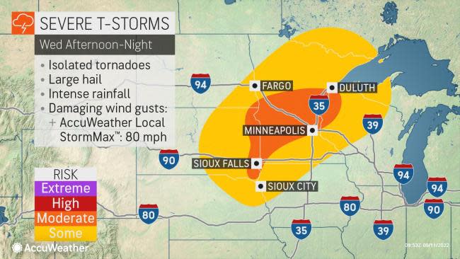
All forms of severe weather will be possible Wednesday evening, ranging from tornadoes to large hail, powerful wind gusts and flooding downpours.
"The Twin Cities and much of central Minnesota will be in direct firing range of these thunderstorms, though anywhere from northern Nebraska to southern Ontario, Canada, could see these impacts into Wednesday night," AccuWeather Meteorologist Jessica Storm said.
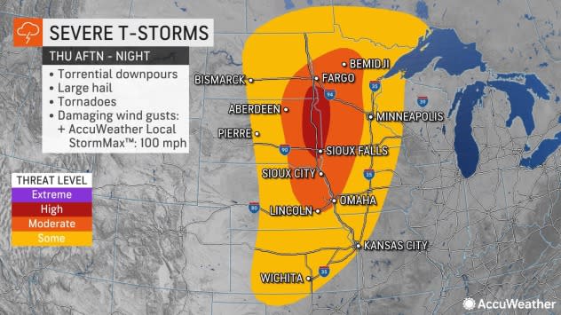
More severe storms will fire up Thursday as a dip in the jet stream that has persisted over the Northwest shifts eastward. Severe thunderstorms are likely to erupt from Oklahoma to Ontario.
"Thursday could shape up to be the worst severe round of the three," Storm said. Once again, all modes of severe weather can occur, including the risk of multiple tornadoes. Heavy rainfall could aggravate existing flooding, especially along the Red River of the North.
 |
Cities such as Fargo, North Dakota; Sioux Falls, South Dakota; and Lincoln, Nebraska, could be at risk for damage and disruptions as storms erupt and move through during the afternoon and evening hours Thursday. Travel on portions of interstates 29, 35, 70, 80, 90, and 94 may be adversely affected.
The greatest threat for violent storms with tornadoes, large hail and powerful wind gusts on Thursday may focus along the Red River Valley of the North. AccuWeather Local StormMax™ wind gusts to near 100 mph are possible in the strongest storms.
"Motorists are reminded to never attempt to drive through high water or around barricades. Anyone planning to be out in the elements might want to reconsider travel plans as flooding on roadways can be particularly difficult to see at night, and conditions can often change rapidly," Storm said.
Track these severe weather conditions and more with the AccuWeather app. For next-level safety, unlock AccuWeather Alerts™ with Premium+. These advanced, hyperlocal notifications are prompted by our expert meteorologists and are often delivered much further ahead of government warnings when possible.
